COLLECTION NAME:
David Rumsey Historical Map Collection
Record
Author:
Palmer, William. J.
Date:
1869
Short Title:
Map Of The Route Of The Southern Continental Rail Road
Publisher:
J.F. Gedney Lith.
Publisher Location:
Washington
Type:
Separate Map
Obj Height cm:
76
Obj Width cm:
95
Scale 1:
3,800,000
Note:
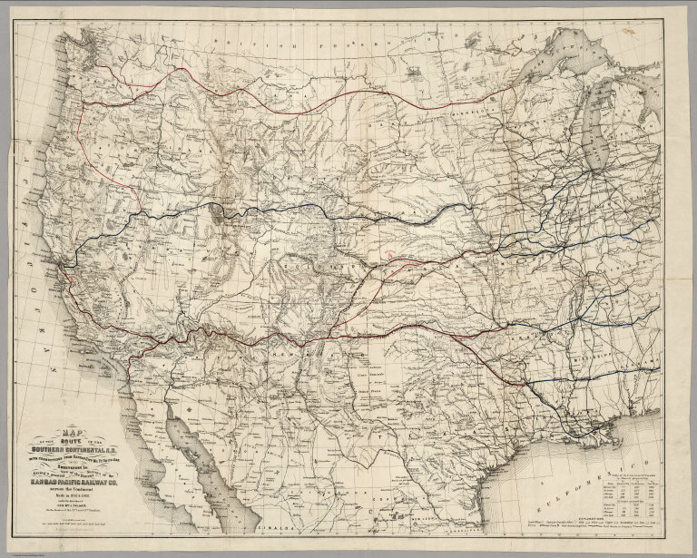
Removed from Palmer's 1869 "Report of Surveys...for a route extending the Kansas Pacific Railway to the Pacific Ocean." Palmer used an exact copy Keeler's 1868 reduced scale edition of his National Map of the United States without credit in this first issue although Palmer's map adds much material along the line of the proposed southern continental route, especially in the Grand Canyon; in fact, this map is best known as the first map to use the name "Grand Canyon" of the Colorado. The Kansas Pacific had dreams of extending their line to California, as shown on this map, but it never happened. The map shows the routes of the Northern Pacific, the Union and Central Pacific, and the Southern Route. Ms color red and blue lines have been drawn on the various routes, adding an additional route from Centreville, Nevada, to Portland, Oregon (probably following Dodge's proposals - see his report). The main Kansas Pacific line has at least sixteen proposed branches! There is a later issue of this map that credits Keeler as a source (see our copy).
Reference:
Wheat 1206; cf Howes P54 (Report of Surveys...).
State/Province:
U.S. Mid West
State/Province:
U.S. West
Subject:
Railroad
Full Title:
Map Of The Route Of The Southern Continental R.R. With Connections From Kansas City Mo. Ft. Smith Ark. And Shreveport La. Giving a general View of the Recent Surveys of the Kansas Pacific Railway Co, across the Continent Made in 1867 & 1868 under the direction of Gen. Wm. J. Palmer. On the routes of the 32nd and 35th Parallels. J.F Gedney Lith, Washington, D.C.
List No:
3725.000
Series No:
1
Publication Author:
Palmer, William. J.
Pub Date:
1869
Pub Title:
Map Of The Route Of The Southern Continental R.R. With Connections From Kansas City Mo. Ft. Smith Ark. And Shreveport La. Giving a general View of the Recent Surveys of the Kansas Pacific Railway Co, across the Continent Made in 1867 & 1968 under the direction of Gen. Wm. J. Palmer. On the routes of the 32nd and 35th Parallels. J.F Gedney Lith, Washington, D.C.
Pub Reference:
Wheat 1206; cf Howes P54 (Report of Surveys...).
Pub Note:
Removed from Palmer's 1869 "Report of Surveys...for a route extending the Kansas Pacific Railway to the Pacific Ocean." Palmer used an exact copy Keeler's 1868 reduced scale edition of his National Map of the United States without credit in this first issue although Palmer's map adds much material along the line of the proposed southern continental route, especially in the Grand Canyon; in fact, this map is best known as the first map to use the name "Grand Canyon" of the Colorado. The Kansas Pacific had dreams of extending their line to California, as shown on this map, but it never happened. The map shows the routes of the Northern Pacific, the Union and Central Pacific, and the Southern Route. Ms color red and blue lines have been drawn on the various routes, adding an additional route from Centreville, Nevada, to Portland, Oregon (probably following Dodge's proposals - see his report). The main Kansas Pacific line has at least sixteen proposed branches! There is a later issue of this map that credits Keeler as a source (see our copy). Relief shown by hachures.
Pub List No:
3725.000
Pub Type:
Separate Map
Pub Height cm:
76
Pub Width cm:
95
Image No:
3725000
Authors:
Palmer, William. J.