COLLECTION NAME:
David Rumsey Historical Map Collection
Record
Author:
Hood, Washington
Author:
Graham, Maj. J.D.
Date:
1836
Short Title:
Composite: Map Of The Extremity Of Cape Cod
Publisher:
U.S.
Publisher Location:
Washington
Type:
Chart Map
Obj Height cm:
147
Obj Width cm:
179
Scale 1:
10,560
Note:
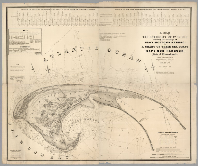
Composite of all four sheets. Huge 4 part chart, each 78 x 94 cm., beautifully engraved by Hood. Not in Phillips or Claussen & Friis. A major chart which was compiled by many of the topographical engineers who went on to become famous figures in western mapping and exploration: Graham, Macomb, Johnston, Humphreys, Palmer and Henderson. Hood's engraving is extremely clear and well done. 25th Congress, 2nd Session, House Document 121. Chart is without color. Relief shown by hachures and spot heights. Depths shown by isolines and soundings. Includes notes, references, and 2 diagrams of the tides at high and low water in Cape Cod Harbor for the months of Oct. 1833 and June 1835.
Reference:
Guthorn p15.
State/Province:
Massachusetts
City:
Provincetown
City:
Truro
Region:
Cape Cod Harbor
Subject:
Nautical Charts
Full Title:
(Composite of) A Map Of The Extremity Of Cape Cod Including the Townships of Provincetown & Truro: A Chart Of Their Sea Coast And Of Cape Cod Harbour, State of Massachusetts. Executed under the direction of Major J.D. Graham U.S. Top. Engs. During portions of the years 1833,'34, &'35 ... W.J. Stone Sc. Wash. Surveyed And Projected By J.D. Graham ... Drawn From The Original Projects And Notes, By J.E. Johnston ... A.A. Humphreys .... J.. Macomb ... W.R. Palmer ... Reduced from the original in the Bureau of U.S. Topographical Engineers, Washington, by Wash: Hood 1836.
List No:
2433.005
Series No:
5
Engraver or Printer:
Humphreys, A.A.
Engraver or Printer:
Stone, W.J.
Engraver or Printer:
Hood, Washington
Engraver or Printer:
Graham, J.D.
Engraver or Printer:
Izard, J.F.
Engraver or Printer:
Lee, T.L.
Engraver or Printer:
Macomb, J.N.
Engraver or Printer:
Johnston, J.E.
Engraver or Printer:
Henderson, J.E.
Engraver or Printer:
Palmer, W.R.
Publication Author:
Graham, Maj. J.D.
Publication Author:
Hood, Washington
Pub Date:
1836
Pub Title:
A Map Of The Extremity Of Cape Cod Including the Townships of Provincetown & Truro: A Chart Of Their Sea Coast And Of Cape Cod Harbour, State of Massachusetts. Executed under the direction of Major J.D. Graham U.S. Top. Engs. During portions of the years 1833,'34, &'35 ... W.J. Stone Sc. Wash. Surveyed And Projected By J.D. Graham ... Drawn From The Original Projects And Notes, By J.E. Johnston ... A.A. Humphreys .... J.. Macomb ... W.R. Palmer ... Reduced from the original in the Bureau of U.S. Topographical Engineers, Washington, by Wash: Hood 1836.
Pub Reference:
Guthorn p15.
Pub Note:
Huge 4 part chart beautifully engraved by Hood. Not in Phillips or Claussen & Friis. A major chart which was compiled by many of the topographical engineers who went on to become famous figures in western mapping and exploration: Graham, Macomb, Johnston, Humphreys, Palmer and Henderson. Hood's engraving is extremely clear and well done. 25th Congress, 2nd Session, House Document 121.
Pub List No:
2433.000
Pub Type:
Chart Map
Pub Maps:
4
Pub Height cm:
147
Pub Width cm:
179
Image No:
2433005
Authors:
Hood, Washington; Graham, Maj. J.D.