COLLECTION NAME:
David Rumsey Historical Map Collection
Record
Author:
Colton, J.H.
Date:
1864
Short Title:
Map Of The Southern States
Publisher:
J.H. Colton
Publisher Location:
New York
Type:
Pocket Map
Obj Height cm:
97
Obj Width cm:
131
Scale 1:
1,584,000
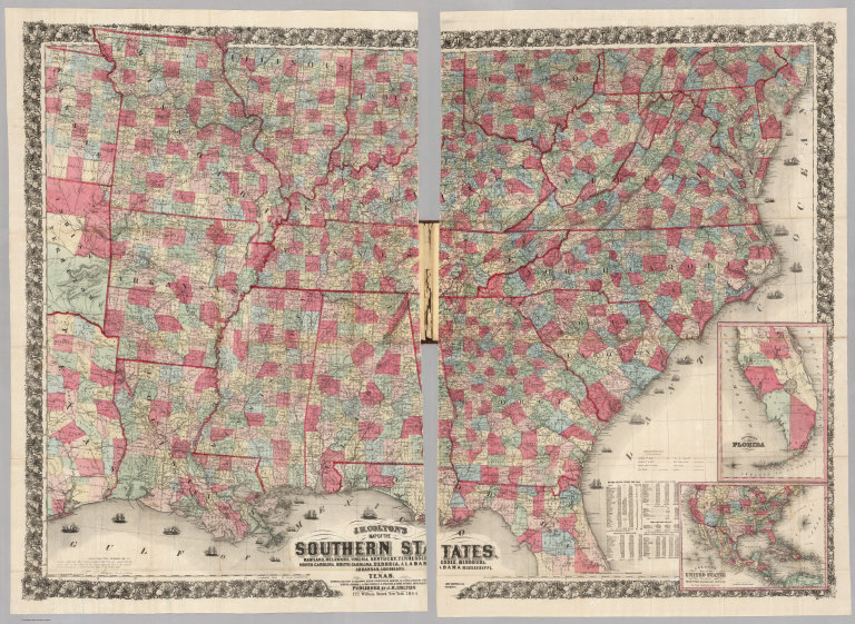
Note:
Large and detailed map in two sheets of the Confederacy, taken from the southern portion of the J. Calvin Smith Map of the Untied States and the Canadas, first issued in 1843, here updated to 1864. The copyright date is 1863, but Colton issued the map in 1861 and 1862; Stephenson shows the 1862 edition by Bacon of London (who issued many of Colton's Civil War maps). An inset map of the United States shows the proposed railroad routes to the Pacific Ocean. Tables list information from the U.S. Census of 1860. Map is in full color by county, and folded into beautifully stamped brown cloth covers 21x13 with clover leaf design and title "Colton's Map Of The Southern States, Showing The Counties & Railroads, Cities, Towns, Railroad Stations, &c. J.H. Colton." in gilt. Prime meridian is Washington D.C.
Reference:
Stephenson 37.6 (1863 edition).
State/Province:
U.S. South
Event:
U.S. Civil War
Full Title:
J.H. Colton's Map Of The Southern States. Maryland, Delaware, Virginia, Kentucky, Tennessee, Missouri, North Carolina, South Carolina, Georgia, Alabama, Mississippi, Arkansas, Louisiana, And Texas. Showing Also Part Of Adjoining States & Territories Locating The Forts & Military Stations Of The U. States & Showing All The Railroads, R.R. Stations & Other Internal Improvements. Published By J.H. Colton, 172 William Street, New York. 1864. Entered ... 1863 by J.H. Colton ... New York. Printed by Lang & Cooper, 117 Fulton St. (inset) Colton's Map of the United States Showing the Proposed Railroad Routes To The Pacific Ocean. (inset) Southern Part Of Florida.
List No:
4085.002
Series No:
2
Engraver or Printer:
Lang & Cooper
Publication Author:
Colton, J.H.
Pub Date:
1864
Pub Title:
J.H. Colton's Map Of The Southern States. Maryland, Delaware, Virginia, Kentucky, Tennessee, Missouri, North Carolina, South Carolina, Georgia, Alabama, Mississippi, Arkansas, Louisiana, And Texas. Showing Also Part Of Adjoining States & Territories Locating The Forts & Military Stations Of The U. States & Showing All The Railroads, R.R. Stations & Other Internal Improvements. Published By J.H. Colton, 172 William Street, New York. 1864. Entered ... 1863 by J.H. Colton ... New York. Printed by Lang & Cooper, 117 Fulton St. (inset) Colton's Map of the United States Showing the Proposed Railroad Routes To The Pacific Ocean. (inset) Southern Part Of Florida.
Pub Reference:
Stephenson 37.6 (1863 edition).
Pub Note:
See note field above.
Pub List No:
4085.000
Pub Type:
Pocket Map
Pub Height cm:
21
Pub Width cm:
13
Image No:
4085002
Authors:
Colton, J.H.