COLLECTION NAME:
David Rumsey Historical Map Collection
Record
Author:
Andreas, A. T. (Alfred Theodore), 1839-1900
Author:
Baskin, Forster and Company
Date:
1876
Short Title:
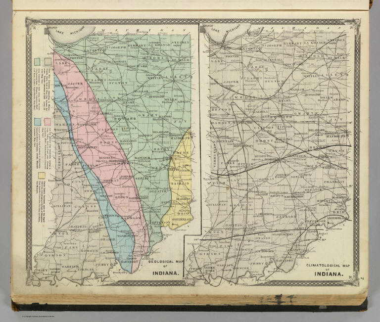
Geological map of Indiana. Climatological map of Indiana.
Publisher:
Baskin, Forster & Co.
Publisher Location:
Chicago
Type:
Atlas Map
Obj Height cm:
34
Obj Width cm:
42
Scale 1:
1,401,400
Note:
Two lithographed, hand col. maps. Climatological map shows mean annual temperature isolines.
Reference:
Checklist of printed maps of the Middle West to 1900, 3-0608, 3-0611; P-Maps, p. 335; Ristow, American maps and mapmakers, p. 438-441; P1599.
State/Province:
Indiana
Subject:
Climate
Subject:
Geology
Full Title:
Geological map of Indiana. Climatological map of Indiana. (Published by Baskin, Forster & Co. Lakeside Building Chicago, Ills. 1876. Engraved & Printed by Chas. Shober & Co. Props. of Chicago Lithographing Co.)
List No:
0019.001
Page No:
7
Series No:
5
Engraver or Printer:
Chas. Shober & Co.
Publication Author:
Andreas, A. T. (Alfred Theodore), 1839-1900
Publication Author:
Baskin, Forster Co.
Pub Date:
1876
Pub Title:
Illustrated historical atlas of the State of Indiana. Published by Baskin, Forster & Co. Lakeside Building Chicago, Ills. 1876. Engraved & Printed by Chas. Shober & Co. Props. of Chicago Lithographing Co.
Pub Reference:
P-Maps, p. 335; Ristow, American maps and mapmakers, p. 438-441; P1599.
Pub Note:
A.T. Andreas is the "hidden" author due to his bankruptcy. Atlas is bound in half leather black cloth covered boards with "Illustrated Historical Atlas Of The State Of Indiana 1876" stamped in gilt. Most maps printed in full color, a few hand col.
Pub List No:
0019.000
Pub Type:
State Atlas
Pub Maps:
150
Pub Height cm:
45
Pub Width cm:
38
Image No:
0019001
Authors:
Andreas, A. T. (Alfred Theodore), 1839-1900; Baskin, Forster and Company
Collection:
Rumsey Collection