COLLECTION NAME:
David Rumsey Historical Map Collection
Record
Author:
Cruchley, G.
Author:
Laurie, Richard Holmes
Date:
1833
Short Title:
Fredonia Or The United States of North America.
Publisher:
G. Cruchley
Publisher Location:
London
Type:
Case Map
Obj Height cm:
64
Obj Width cm:
97
Scale 1:
570,000
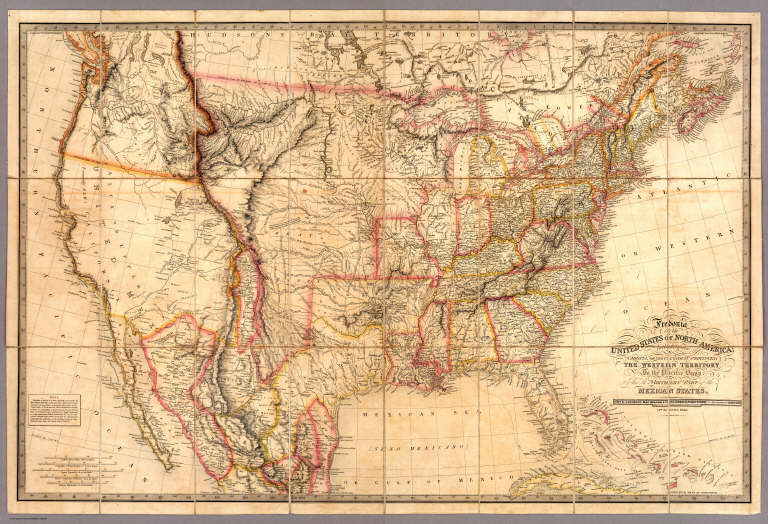
Note:
The third edition (although I can detect no changes from the first issue of 1830). Has the note in the lower left explaining the origin of the term of Fredonia. This map is the only one I have seen that copies almost literally three earlier maps: Lewis and Clark (1814), Long (1822), and Arrowsmith's Mexico (1820). Laurie used the term Fredonia, we may assume, to create a novelty of his map, in the same manner as his "Cabotia" map of 1814. Has the original case with label, and an advertisement for Crunchley's publications on the verso of the map. W. Heckrotte has another edition dated 1834 improved to 1836 (with changes in California based on John Arrowsmith's Map of British North America, 1834), and the second edition of 1832. The western topography is changed to incorporate Arrowsmith's map of 1834 (British North America) and an independent Texas is shown. Editions seen of 1830, 1832, 1834, 1836, 1849. It appears that the map was updated frequently in order to keep it current. It is an excellent and beautiful map.
Reference:
cf Wheat 393 (1830 ed); Streeter 3845, 3846.
Country:
Mexico
Country:
United States
Full Title:
Fredonia Or The United States of North America; Including Also Cabotia, Or The Canadian Provinces; The Western Territory To The Pacific Ocean; And the Northern Part of the Mexican States. 14th August, 1830. Additions 1833.
List No:
3827.001
Series No:
2
Publication Author:
Cruchley, G.
Publication Author:
Laurie, Richard Holmes
Pub Date:
1833
Pub Title:
Fredonia Or The United States of North America; Including Also Cabotia, Or The Canadian Provinces; The Western Territory To The Pacific Ocean; And the Northern Part of the Mexican States. 14th August, 1830. Additions 1833.
Pub Reference:
cf Wheat 393 (1830 ed.); Streeter 3845, 3846.
Pub Note:
The third edition (although I can detect no changes from the first issue of 1830). Has the note in the lower left explaining the origin of the term Fredonia. This map is the only one I have seen that copies almost literally three earlier maps: Lewis and Clark (1814), Long (1822), and Arrowsmith's Mexico (1820). Laurie used the term Fredonia, we may assume, to create a novelty of his map, in the same manner as his "Cabotia" map of 1814. Has the original case with label, and an advertisement for Cruchley's publications on the verso of the map. WH has another edition dated 1834 improved to 1836 (with changes in California based on John Arrowsmith's Map of British North America, 1834), and the second edition of 1832. The western topography is changed to incorporate Arrowsmith's map of 1834 (British North America) and an independent Texas is shown. Editions seen of 1830, 1832, 1833, 1834, 1836, 1849. It appears that the map was updated frequently in order to keep it current. It is an excellent and beautiful map.
Pub List No:
3827.000
Pub Type:
Case Map
Pub Maps:
2
Pub Height cm:
23
Pub Width cm:
13
Image No:
3827001
Authors:
Cruchley, G.; Laurie, Richard Holmes
Collection:
Rumsey Collection