COLLECTION NAME:
David Rumsey Historical Map Collection
Record
Author:
United States Geological Survey (USGS)
Author:
Bayer, Kenneth C.
Date:
1983
Short Title:
United States -- Geology: Physiographic & Structural Provinces
Publisher:
United States Geological Survey (USGS)
Publisher Location:
Washington D.C.
Type:
Wall Map
Obj Height cm:
123
Obj Width cm:
276
Scale 1:
2,500,000
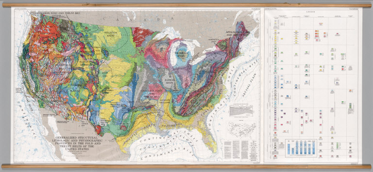
Note:
Suitable for use in a large lecture hall; viewable to and beyond 40 feet. Language(s): English. Map is plasticized paper. Mounted on wood rods. Prime Meridian is Greenwich. Projection is Lambert's conformal conic. Length of rolled wall map is 395 cm. Topics include: geology, structural lithographic and physiographic provinces, internal political divisions, state and county names. Department of Geography, University of California at Berkeley, Call Number 600-B-4.
Reference:
UC Berkeley, Geography Department Call Number 600-B-4.
Country:
United States
Subject:
Geology
Full Title:
Generalized Structural Lithographic and Physiographic Provinces in the Fold and Thrust Belts of the United States, (exclusive of Alaska and Hawaii).
List No:
7130.000
Series No:
1
Publication Author:
Bayer, Kenneth C.
Publication Author:
United States Geological Survey (USGS)
Pub Date:
1983
Pub Title:
Generalized Structural Lithographic and Physiographic Provinces in the Fold and Thrust Belts of the United States, (exclusive of Alaska and Hawaii).
Pub Reference:
UCBGEOG1
Pub Note:
See Note field above.
Pub List No:
7130.000
Pub Type:
Wall Map
Pub Maps:
1
Pub Height cm:
117
Pub Width cm:
194
Image No:
7130000
Authors:
United States Geological Survey (USGS); Bayer, Kenneth C.