COLLECTION NAME:
David Rumsey Historical Map Collection
Record
Author:
Smith, J.L.
Author:
Smith, A. DW.
Date:
1899
Short Title:
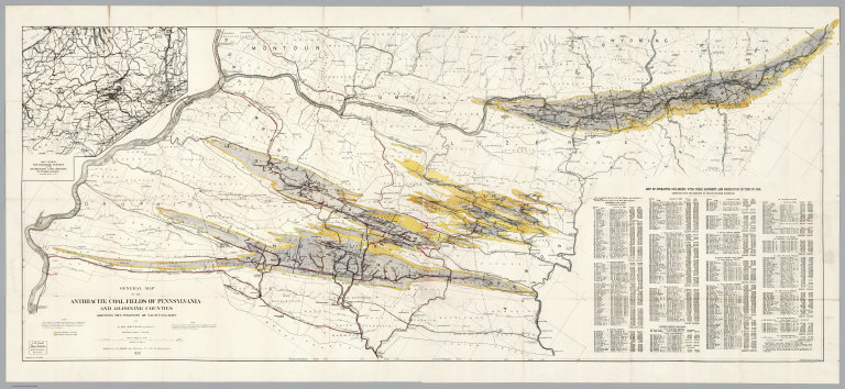
Composite: General Map Of The Anthracite Coal Fields Of Pennsylvania And Adjoining Counties
Publisher:
J.L. Smith
Publisher Location:
Philadelphia
Type:
Composite Map
Obj Height cm:
62
Obj Width cm:
146
Scale 1:
126,720
Note:
Late, detailed map of the Pennsylvania coal fields. On the map is a note: "This map is a revised copy of the 'General Map of the Anthracite Coal Fields' published by the Pennsylvania Geological Survey in 1890; and is republished by permission of the Board of Commissioners." Includes a "List of operating collieries, with their shipment and production in Tons in 1898". Prime meridian is Washington.
Reference:
None found
State/Province:
Pennsylvania
Subject:
Mining
Full Title:
(Composite of) General Map Of The Anthracite Coal Fields Of Pennsylvania And Adjoining Counties Showing The Position Of Each Colliery. By A. DW. Smith, Mining Engineer. Wilkes-Barre, Penna. Published by J.L. Smith, Map Publisher, 27 S. 6th St., Philadelphia 1899. Copyrighted 1899 By A. DW. Smith. (inset) Map Showing The Railroad Outlets Of The Anthracite Coal Regions Of Pennsylvania.
List No:
5069.003
Series No:
3
Publication Author:
Smith, J.L.
Publication Author:
Smith, A. DW.
Pub Date:
1899
Pub Title:
General Map Of The Anthracite Coal Fields Of Pennsylvania And Adjoining Counties Showing The Position Of Each Colliery. By A. DW. Smith, Mining Engineer. Wilkes-Barre, Penna. Published by J.L. Smith, Map Publisher, 27 S. 6th St., Philadelphia 1899. Copyrighted 1899 By A. DW. Smith. (inset) Map Showing The Railroad Outlets Of The Anthracite Coal Regions Of Pennsylvania.
Pub Reference:
None found.
Pub Note:
Late, detailed map of the Pennsylvania coal fields; folded into dark brown cloth covers 19x11 with "Anthracite Coal Fields Of Pennsylvania J.L. Smith 1899" in gilt. On the map is a note: "This map is a revised copy of the 'General Map of the Anthracite Coal Fields' published by the Pennsylvania Geological Survey in 1890; and is republished by permission of the Board of Commissioners."
Pub List No:
5069.000
Pub Type:
Pocket Map
Pub Height cm:
62
Pub Width cm:
146
Image No:
5069003
Authors:
Smith, J.L.; Smith, A. DW.
