COLLECTION NAME:
David Rumsey Historical Map Collection
Record
Author:
Great Britain. War Office
Author:
Stevens, Benjamin Franklin
Date:
1782
Short Title:
Steven's facsimile of British head quarters manuscript map of New York
Publisher:
Malby and Sons, engravers
Publisher Location:
London
Type:
Manuscript Map
Type:
Separate Map
Obj Height cm:
123
Obj Width cm:
305
Scale 1:
9,800
Note:
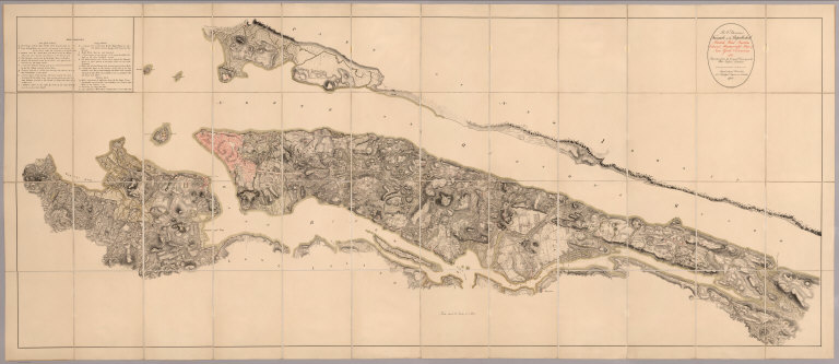
From the printed advertisement for the map: "BF STEVENS'S Facsimile of the Unpublished British Headquarters Coloured Manuscript Map of New York and Environs 1782. Reproduced from the Original Drawing in the War Office London. 24 sheets Scale 6 1/2 inches to a mile. 10 feet by 4 feet. The successive British Commanders in Chief in America Generals Sir William Howe, Sir Henry Clinton, and Sir Guy Carleton during their respective occupations of New York and Environs in the Revolution caused this manuscript plan from time to time to be kept up. The plan extends from below Guanas Bay to the Heights of Spikendevi, a distance of about eighteen or nineteen miles. It shows the Fortifications, Defenses, Topography, Streets, Roads, etc. of the whole of the Island of New York with the Harbor Islands, Water Ways, and River Frontages on the Hudson and East Rivers, the Military Works on Long Island including Brooklyn, the Works in Paulus Hook and parts of the Jersey Shore. It has a copious Table of References to various works British and American, some of them with notes as to the time of their construction or destruction. The Original Drawing, ten feet by four feet, is on a scale of about six and a half inches to a mile. It is handsomely reproduced for subscribers only in careful facsimile on 24 sheets which can be joined up and mounted like the original as a Wall Map or mounted on linen if desired. It will be issued either mounted on linen to fold in book form with leather slip case 13 x 10 inches or the 24 sheets 22 x 15 inches, each will be supplied in a portfolio. No more than 100 copies are being printed and the engravings are erased as each sheet is printed off. A few extra copies of sheet 8 have been printed so that it can be sent as a specimen on application from intending subscribers. .." View in Google Earth
State/Province:
New York
City:
New York (N.Y.)
Region:
Long Island
Event:
American Revolution
Full Title:
B.F. Steven's Facsimile of the Unpublished British Head Quarters Coloured Manuscript map of New York & Environs, 1782, Reproduced from the original drawing in the War Office, London. Issued only to subscribers at 4, Trafalgar Square, W.C., London. 1900. Malby and Sons. Engravers.
List No:
6403.003
Series No:
3
Publication Author:
Great Britain. War Office
Publication Author:
Stevens, Benjamin Franklin
Pub Date:
1782
Pub Title:
B.F. Steven's Facsimile of the Unpublished British Head Quarters Coloured Manuscript map of New York & Environs, 1782, Reproduced from the original drawing in the War Office, London. Issued only to subscribers at 4, Trafalgar Square, W.C., London. 1900. Malby and Sons. Engravers.
Pub Note:
One color map 123 x 305 cm. on 48 sheets, mounted on linen; folded to 33x26, with paper covers title pasted on outside of folded map ; Place in red hard cover slip-case, 34.5x27.5. with title "Steven's facsimile of British head quarters manuscript map of New York (1782) London 1901". Includes references to New York Island and Long Island.
Pub List No:
6403.000
Pub Type:
Manuscript Map
Pub Type:
Separate Map
Pub Height cm:
35
Pub Width cm:
28
Image No:
6403003
Authors:
Great Britain. War Office; Stevens, Benjamin Franklin