COLLECTION NAME:
David Rumsey Historical Map Collection
Record
Attributed Author:
William P. Humphreys & Co.
Date:
1876
Short Title:
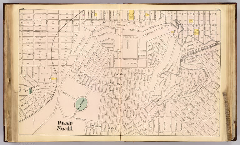
Plat 41 [San Francisco)
Publisher:
W. Humphreys
Publisher Location:
San Francisco
Type:
Atlas Map
Obj Height cm:
42
Obj Width cm:
66
Scale 1:
4,800
Note:
Hand col. map. Relief shown by spot heights. Shows block numbers, sewers, etc. Covers area bounded by Clipper, 26th, Arkansas, Crescent, Noe, including Islais Creek Channel, Holly Park and Fairmount Plaza.
State/Province:
California
City:
San Francisco (Calif.)
Full Title:
Plat no. 41 (San Francisco. (Compiled and published by Wm. P. Humphreys & Co., A.B. Holcombe, W.C. Kewen. Eng. by Worley & Bracher ... Phila, Pa. Printed by F. Bourquin ... Phila, Pa. 1876.)
List No:
0329.039
Page No:
138-139
Series No:
42
Engraver or Printer:
Bourquin, F. (Frederick), b. 1808
Engraver or Printer:
Worley & Bracher
Publication Author:
William P. Humphreys & Co.
Pub Date:
1876
Pub Title:
Atlas of the city and county of San Francisco from actual surveys and official records. Compiled and published by Wm. P. Humphreys & Co., A.B. Holcombe, W.C. Kewen. Eng. by Worley & Bracher ... Phila, Pa. Printed by F. Bourquin ... Phila, Pa. 1876.
Pub Reference:
LeGear. Atlases of the United States, L3965; Rocq, M.M. California local history (2nd ed.), 9897; Rowell, J.C. List of printed maps of California, 1887, p. 21
Pub Note:
See note field above.
Pub List No:
0329.000
Pub Type:
City Atlas
Pub Maps:
60
Pub Height cm:
45
Pub Width cm:
38
Image No:
0329039
Authors:
William P. Humphreys & Co.
Collection:
Rumsey Collection