COLLECTION NAME:
David Rumsey Historical Map Collection
Record
Author:
Hayward, James
Date:
1828
Short Title:
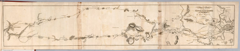
Plan of a survey for the proposed Boston and Providence rail way
Publisher:
Board of Commissioners
Publisher Location:
Boston: Mass.
Type:
Book Map
Obj Height cm:
19
Obj Width cm:
106
Scale 1:
63,360
Note:
Map is uncolored. Shows 2 possible routes between Boston and Providence. Relief shown by hachures.
Reference:
Modelski US-348; Modelski NA-1; Sabin 6768 p.332.
State/Province:
Massachusetts
State/Province:
Rhode Island
Subject:
Railroad
Full Title:
Plan of a survey for the proposed Boston and Providence rail way. By James Hayward. Jan. 1828. (engraved by) Annin & Smith. (to accompany) Report of the Board of Commissioners, of Internal Improvement in Relation to the Examination of Sundry Routes for a Railway from Boston to Providence.
List No:
0324.006
Series No:
6
Engraver or Printer:
Annin & Smith
Publication Author:
Hayward, James
Pub Date:
1828
Pub Title:
Report of the Board of Commissioners, of Internal Improvement in Relation to the Examination of Sundry Routes for a Railway from Boston to Providence. With a Memoir of the Survey. Senate No. 4. Boston: Dutton & Wentworth...Printers to the State ... 1828. (with) Plan of A Survey For the Proposed Boston and Providence Rail-Way. by James Hayward. Jan. 1828. Annin & Smith.
Pub Reference:
Modelski US-348; Modelski NA-1; Sabin 6768 p.332.
Pub Note:
Earliest RR map in LOC collection. Sabin provides report publication data. Map is uncolored and measures 19x106 at a scale of 1:63,360 (1 inch=1 mile).
Pub List No:
0324.000
Pub Type:
Gov't Report Book
Pub Height cm:
25
Pub Width cm:
16
Image No:
0324006
Authors:
Hayward, James