COLLECTION NAME:
David Rumsey Historical Map Collection
Record
Author:
Amerine, C.H.
Date:
1891
Short Title:
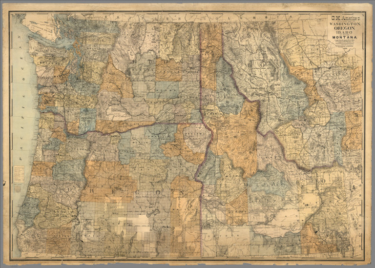
Sectional map of Washington, Oregon, Idaho, and western Montana
Publisher:
C.H.Amerine
Publisher Location:
San Francisco,Tacoma, Wash.
Publisher:
Schmidt Lable & Lith Co.
Publisher Location:
San Francisco,Tacoma, Wash.
Type:
Separate Map
Obj Height cm:
108
Obj Width cm:
152
Scale 1:
760,320
Note:
Amerine published several maps of Washington, Oregon, Puget Sound and other areas of the Pacific Northwest, but this is his only multi-state map that we know of and it is not held in any libraries listed in WorldCat. Full color map, backed with linen. Shows capitals, county, towns, wagon roads, railroads, trails, reservations, light houses, blocks, subdivisions, etc. Includes explanation and table of township subdivision. Relief shown by hachures. Prime meridian is Washington.
State/Province:
Idaho
State/Province:
Montana
State/Province:
Oregon
State/Province:
Washington
Subject:
Land Development
Subject:
Mining
Subject:
Railroad
Full Title:
C.H. Amerine's : Sectional map of Washington, Oregon, Idaho, and western Montana. Compiled from latest official data exploration and other sources. Compiled and published by C.H. Amerine, 1891. Copyrighted by C.H. Amerine, Tacoma, Wash. Photo - Litho by Schmidt Lable & Lith Co. S.F.
List No:
6744.000
Series No:
1
Publication Author:
Amerine, C.H.
Pub Date:
1891
Pub Title:
C.H. Amerine's : Sectional map of Washington, Oregon, Idaho, and western Montana. Compiled from latest official data exploration and other sources. Compiled and published by C.H. Amerine, 1891. Copyrighted by C.H. Amerine, Tacoma, Wash. Photo - Litho by Schmidt Lable & Lith Co. S.F.
Pub Note:
See note field above.
Pub List No:
6744.000
Pub Type:
Separate Map
Pub Height cm:
108
Pub Width cm:
152
Image No:
674400
Authors:
Amerine, C.H.