COLLECTION NAME:
David Rumsey Historical Map Collection
Record
Author:
Mitchell, Samuel Augustus
Date:
1859
Short Title:
Crimea.
Publisher:
Charles Desilver
Publisher Location:
Philadelphia
Type:
Atlas Map
Obj Height cm:
41
Obj Width cm:
68
Scale 1:
665,000
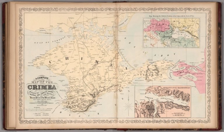
Note:
Double page map. Relief shown by hachures. Insets of Sebastopol Harbour, and Map Showing the relative Position of the Crimea with the Seat of War.
Reference:
P6135.
Country:
Russia
Country:
Ukraine
Region:
Crimea
Event:
Crimean War
Subject:
Military
Full Title:
A Complete Map of the Crimea Showing the Military and Carriage Roads with Distances from Various Points of the Western Coast From English & Russian Surveys. Philadelphia. Published by Charles Desilver, 251 Market St. Herline & Co. Lith., 7th & Chesnut Sts., Philadelphia. Entered according to Act of Congress in the year 1856 by Charles Desilver in the Clerk's office if the District Court of the Eastern District of Pennsylvania.
List No:
8065.080
Series No:
61
Publication Author:
Mitchell, Samuel Augustus
Pub Date:
1860
Pub Title:
A New Universal Atlas Containing Maps of the various Empires, Kingdoms, States and Republics Of The World. With a special map of each of the United States, Plans of Cities &c. Comprehended in eighty one sheets and forming a series of One Hundred And Forty Five Maps, Plans And Sections ... Philadelphia, Charles Desilver, 714 Chesnut Street. 1859. Entered ... 1859, by Charles Desilver ... Pennsylvania. (title page by) J. Knight Sc.
Pub Reference:
P6135.
Pub Note:
This 1859 edition was published by Charles Desilver, copyright dates have been updated to 1859 or 1860, and was most likely issued in late 1859 or early 1860, as opposed to the previous 1859 edition that was published by Cushing & Bailey of 362 Market Street in Baltimore, with almost all copyrights dated 1856 (see: #4557.000). The maps bear the copyright and imprint of Charles Desilver 714 Chesnut Street. Changes from the 1859 edition includes a new map of Pennsylvania, two double page maps - map of Kansas by W.H. Holmes, and map of Mexico, with no pagination, as well as a double page map of Northern Italy which replaces map of Sardinia (Pl. 63), also various updates to individual maps. Maps in full color. Title page includes the vignette of the "First Landing of Columbus in the New World". Atlas includes 78 plates, some double page. Bound in half red leather brown paper covered boards.
Pub List No:
8065.000
Pub Type:
World Atlas
Pub Maps:
78
Pub Height cm:
45
Pub Width cm:
37
Image No:
8065060.jp2
Authors:
Mitchell, Samuel Augustus