COLLECTION NAME:
David Rumsey Historical Map Collection
Record
Author:
Colomb, John Charles Ready
Author:
Crane, Walter
Date:
1886
Short Title:
Extent of the British Empire in 1886.
Publisher:
The "Graphic"
Publisher Location:
London
Type:
Separate Map
Obj Height cm:
58
Obj Width cm:
77
Scale 1:
None shown
Note:
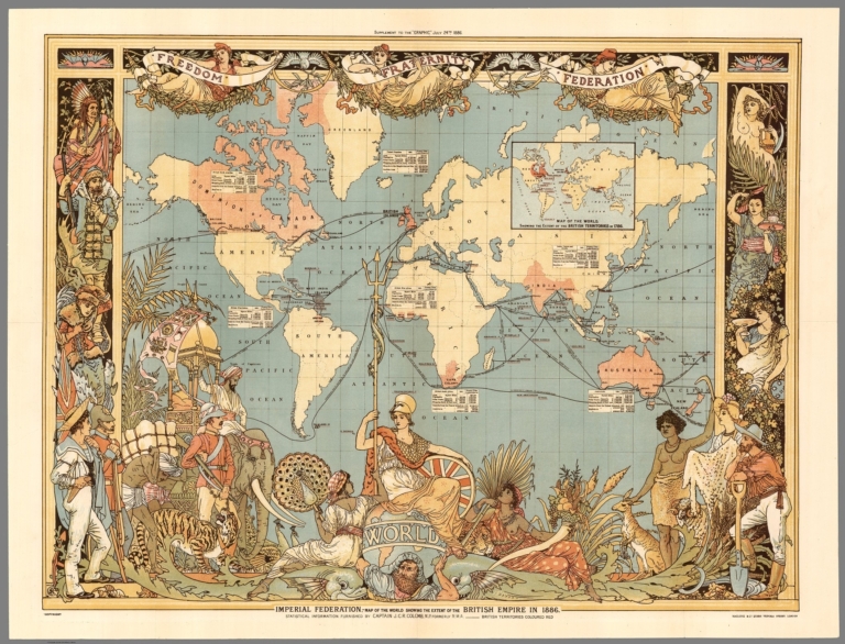
Pictorial map on Mercator projection centered on the Greenwich Prime Meridian, placing Great Britain just above the map's central focal point. Published as a color supplement to The "Graphic." The British Isles, and British colonies spreading out to the east and the west, were highlighted with red, while other geographical areas were left blank with only a minimum number of place names. An inset box was placed near each of the major colonies, listing statistics about geographical area, population, and trade. The words "Freedom, Fraternity, Federation," suggesting a peaceful coexistence within the British Empire, were prominently placed along the map's top margin, but the remainder of the map's illustrations imply "colonialism." At the bottom center Britannia is seated on top of the world ruling over her subjects, represented by a variety of animals and costumed figures. India, identified by an elephant and a tiger, appears in the lower left corner, while Australia, including a kangaroo and a sheep, is shown in the lower right. The illustrations were done by Walter Crane, a prominent illustrator and artist with strong socialist sympathies, perhaps explaining the contradictory themes in the map of imperialism and "human labour" holding up the world in the form of Atlas. Crane's contributions to the map remained unnoticed until the research of Pippa Biltcliffe was published in 2005.
Reference:
Pippa Biltcliffe (2005) Walter Crane and the Imperial Federation Map Showing the Extent of the British Empire (1886), Imago Mundi: The International Journal for the History of Cartography, 57:1, 63-69
World Area:
World
Subject:
Pictorial map
Full Title:
Imperial Federation - Map of the world showing the extent of the British Empire in 1886. Statistical information furnished by Captain J.C.R. Colomb, M.P. formerly R.M.A. Mclure & Co. Queen Victoria Street, London. British territories coloured in red. (Published as) Supplement to ''The Graphic'', July 24th, 1886. (Inset) Map of the world showing the extent of British territories in 1786.
List No:
8238.000
Publication Author:
Colomb, John Charles Ready
Publication Author:
Crane, Walter
Pub Date:
1886
Pub Title:
Imperial Federation - Map of the world showing the extent of the British Empire in 1886. Statistical information furnished by Captain J.C.R. Colomb, M.P. formerly R.M.A. Mclure & Co. Queen Victoria Street, London. British territories coloured in red. (Published as) Supplement to ''The Graphic'', July 24th, 1886. (Inset) Map of the world showing the extent of British territories in 1786.
Pub Note:
See note field above.
Pub List No:
8238.000
Pub Type:
Separate Map
Pub Height cm:
58
Pub Width cm:
77
Image No:
8238000.jp2
Authors:
Colomb, John Charles Ready ; Crane, Walter