COLLECTION NAME:
David Rumsey Historical Map Collection
Record
Author:
United States. War Department
Date:
1895
Short Title:
Campaign: Sterling Price.
Publisher:
U.S. Government Printing Office
Publisher Location:
Washington
Type:
Atlas Map
Obj Height cm:
43
Obj Width cm:
70
Scale 1:
Various
Note:
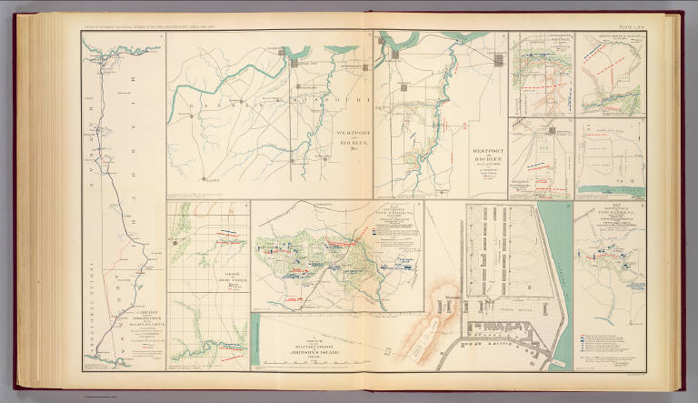
Eleven col. maps. Relief shown by hachures. Accompany documents of S.R. Curtis, William Gamble and S.P. Heintzelman.
State/Province:
Arkansas
State/Province:
Kansas
State/Province:
Missouri
State/Province:
Ohio
County:
Linn County (Kan.)
County:
Newton County (Mo.)
City:
Five Forks (Dinwiddie County, Va.)
Region:
Johnson Island Prison
Region:
Kansas City Region (Mo.)
Event:
U.S. Civil War
Subject:
Military
Full Title:
Campaign against Sterling Price, 1864, Maj. Gen. S.R. Curtis, commanding. Executed under the direction of Lieut. G.T. Robinson, Chief Engineer, by Jacob Miller ... Westport and Big Blue, Mo. Westport and Big Blue, Oct. 22 and 23, 1864, by L.G. Bennett, Topogr. Engineer. Battle-ground of Westport, Oct. 23, 1864 by L.G. Bennett. Battle-ground of Charlot, Oct. 25, 1864. Battle-ground of Newtonia, Mo., October 28, 1864. (Harrison's Landing, Va., July 4, 1862) Osage or Mine Creek, Kans. Map of battle-field of Five Forks, Va., April 1st 1865 and of field of operation preliminary to it, showing the operations of the Fifth Army Corps, commanded by Maj. Gen. G.K. Warren. A sketch of the military prison on Johnson's Island, Ohio. Map of the battle-field of Five Forks, Va., April 1st, 1865 showing the positions of movements of the Fifth Army Corps, commanded by ... G.K. Warren. ... Julius Bien & Co., Lith., N.Y. (1891-1895)
List No:
1780.066
Page No:
pl. LXVI
Series No:
70
Engraver or Printer:
Bennett, L. G.
Engraver or Printer:
Curtis, Samuel R.
Engraver or Printer:
Gamble, William
Engraver or Printer:
Heintzelman, Samuel P.
Engraver or Printer:
Julius Bien & Co.
Engraver or Printer:
Miller, Jacob
Engraver or Printer:
Price, Sterling
Engraver or Printer:
Robinson, George T.
Engraver or Printer:
Warren, Gouverneur Kemble, 1830-1882
Publication Author:
Cowles, Calvin D.
Publication Author:
Davis, George B.
Publication Author:
Kirkley, JAW.
Publication Author:
Perry, Leslie J.
Publication Author:
United States. War Department
Pub Date:
1895
Pub Title:
Atlas to accompany the official records of the Union and Confederate armies. Published under the direction of the Hons. Redfield Proctor, Stephen B. Elkins and Daniel S. Lamont, secretaries of war, by Maj. George B. Davis, U.S. Army, Mr. Leslie J. Perry, civilian expert, Mr. Joseph W. Kirkley, civilian expert, Board of Publication. Compiled by Capt. Calvin D. Cowles, 23d U.S. Infantry. Washington: Government Printing Office, 1891-1895.
Pub Reference:
LC Civil War maps (2nd ed.), 99; Civil War maps in the National Archives, 8; Phillips, 1353; LeGear. Atlases of the United States, 266.
Pub Note:
See note field above.
Pub List No:
1780.000
Pub Type:
Military Atlas
Pub Maps:
158
Pub Height cm:
47
Pub Width cm:
40
Image No:
1780066
Authors:
United States. War Department
Collection:
Rumsey Collection