COLLECTION NAME:
David Rumsey Historical Map Collection
Record
Author:
Abbot, Henry L.
Author:
United States. War Department
Date:
1895
Short Title:
Approaches to New Orleans.
Publisher:
U.S. Government Printing Office
Publisher Location:
Washington
Type:
Atlas Map
Obj Height cm:
43
Obj Width cm:
70
Scale 1:
38,000
Note:
Col. map with 10 ancillary maps. Accompany reports or letters of J. Kilpatrick, Giles A. Smith, J.M. McPherson and T. Seymour.
State/Province:
Alabama
State/Province:
Georgia
State/Province:
Louisiana
State/Province:
Virginia
County:
Paulding County (Ga.)
City:
New Orleans (La.)
Region:
Fairburn Region (Ga.)
Region:
Spanish Fort (Ala. : Fort)
Event:
U.S. Civil War
Subject:
Military
Full Title:
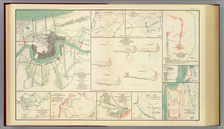
Department of the Gulf. Map no. 5. Approaches to New Orleans, prepared by order of Maj. Gen. N.P. Banks (by) Henry L. Abbot, Capt. and Chief Top. Engrs., Feb. 14th, 1863. (with Fairburn, Ga., Aug. 15-16, 1864). (with) Position of Army of Tennessee near Atlanta, Ga., July 22, 1864. (with) Map of Spanish Fort, Ala., made during the siege by Lieut. J.A. Chalaron ... (with) Diagrams illustrating the different positions occupied by the 4th Division, 17th Army Corps, during the battle of Atlanta, Ga., July 22, 1864. (with) Part of Paulding County, showing the position of the Left Wing, 16th A.C., June 4, 1864. (with) Section of a map showing the lines new New Hope Church, Ga., 1864. From Chief Engineer's Office, Army of Mississippi, by Capt. W.J. Morris, Chief Engineer. (with) Topographical sketch of the position of the Second Division, 14th Army Corps, in front of Savannah, Ga., December 11th, 1864. Brig. Gen. Jas. D. Morgan, commanding Division. Surveyed and drawn by Chas. Petri ... (with) Map of the vicinity of Mechanicsville, Va. (with Spanish Fort, Ala., March 29-April 8, 1865. Chas. G. Johnson). (with) Spanish Fort, 1865. Drawn during siege by assistant surgeon Bull, C.S. Army. Julius Bien & Co., Lith., N.Y. (1891-1895)
List No:
1780.090
Page No:
pl. LXC
Series No:
94
Engraver or Printer:
Banks, Nathaniel P.
Engraver or Printer:
Bull, surgeon.
Engraver or Printer:
Chalaron, J. Adolphus
Engraver or Printer:
Johnson, Charles G.
Engraver or Printer:
Julius Bien & Co.
Engraver or Printer:
Kilpatrick, Judson
Engraver or Printer:
McPherson, James B.
Engraver or Printer:
Morgan, James D.
Engraver or Printer:
Morris, Walter J.
Engraver or Printer:
Petri, Charles
Engraver or Printer:
Seymour, Truman
Engraver or Printer:
Smith, Giles A.
Publication Author:
Cowles, Calvin D.
Publication Author:
Davis, George B.
Publication Author:
Kirkley, JAW.
Publication Author:
Perry, Leslie J.
Publication Author:
United States. War Department
Pub Date:
1895
Pub Title:
Atlas to accompany the official records of the Union and Confederate armies. Published under the direction of the Hons. Redfield Proctor, Stephen B. Elkins and Daniel S. Lamont, secretaries of war, by Maj. George B. Davis, U.S. Army, Mr. Leslie J. Perry, civilian expert, Mr. Joseph W. Kirkley, civilian expert, Board of Publication. Compiled by Capt. Calvin D. Cowles, 23d U.S. Infantry. Washington: Government Printing Office, 1891-1895.
Pub Reference:
LC Civil War maps (2nd ed.), 99; Civil War maps in the National Archives, 8; Phillips, 1353; LeGear. Atlases of the United States, 266.
Pub Note:
See note field above.
Pub List No:
1780.000
Pub Type:
Military Atlas
Pub Maps:
158
Pub Height cm:
47
Pub Width cm:
40
Image No:
1780090
Authors:
Abbot, Henry L.; United States. War Department
Collection:
Rumsey Collection