COLLECTION NAME:
David Rumsey Historical Map Collection
Record
Author:
Bertelli, Donato
Author:
Forlani, Paolo
Author:
Gastaldi, Giacomo
Date:
1568
Short Title:
Universale Descrittione Di Tutta la Terra Conosciuta Fin Qui
Publisher:
Paolo Forlani
Publisher Location:
Venice
Type:
Separate Map
Obj Height cm:
53
Obj Width cm:
81
Scale 1:
Not shown
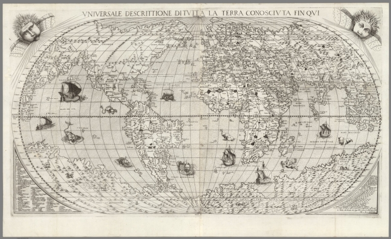
Note:
Relief shown pictorially. There are winged cherub heads in the top two spandrels. The initials "D.B." in the lower right hand corner refer to Donato Bertelli. From: [Italian composite atlases]. Map is made from a new copper plate which is a close copy of Paolo Forlani's world map, which Forlani copied from Giacomo Gastaldi's prototype world map of 1546. From Barry Ruderman: "Generally considered to be the rarest of the so-called Forlani series of World maps, Donato Bertelli's map is drawn from Paolo Forlan's World map of 1565 (Forlani 3), which in turn is based upon Giacomo Gastaldi's 1546 prototype world map and Forlani's earlier world map of 1560. The map is extremely rare, with only the British Library example cited by Shirley, to which Tooley added an example in the Beans-Lloyd-Triestin o Atlas and Woodward further located an example at the John Carter Brown. Unlike the other 4 world maps which have been definitively attributed to Forlani, the modern consensus is that this map is the original work of Donato Bertelli, whose initials appear in the title cartouche. Between 1560 and 1570, Paolo Forlani issued four world maps, with his 1565 map (Forlani 3) being the largest and the most decorative of the sequence. As with Forlani's earlier world maps, Forlani 3 is a re-interpretation of Gastaldi, however a significant addition has been made: a large and extensive southern continent is shown and labeled "Terra Incognita." Forlani has populated the unknown southern land mass with imaginary topographical features as well as unlikely animals - among them a camel, an elephant, a lion, a rhinoceros and most outlandish, a griffin and a unicorn. This feature is faithfully copied by Bertelli. By 1565, Forlani's maps of northern North America included the label "Nueva Franza" to recognize the growing French role in exploring what was still a little-known continent. Despite Gastaldi pioneering the idea of separate Asian and American continents with the addition of the Strait of Anian in 1562, both Bertelli and Forlani disregard this advance. North America is still shown joined to Asia, separated by the "Golfo di Tonzo," with Japan at its center. Many of the eastern coastal features compare well with modern maps; reflecting the incorporation of the latest knowledge about North America's shape from existing charts and explorers' descriptions. Florida and Cuba, for example, are quite accurately positioned. Bertelli's large world map was published in 1568, two years after Venice would reach what David Woodward calls the "zenith of map engraving." The map is highly decorative, featuring two cherubs in the top corners blowing the winds. Other embellishments include: numerous sea monsters, a nude figure riding a large sea creature, nine sailing vessels, and varied land animals.
Reference:
Shirley, R.W. (World) #118; Imago Mundi III (Tooley - Italian Atlases) #14; Woodward, D. Maps and Prints of Paolo Forlani, #82.
World Area:
World
Full Title:
Universale Descrittione Di Tutta la Terra Conosciuta Fin Qui.
List No:
10009.000
Publication Author:
Bertelli, Donato
Publication Author:
Forlani, Paolo
Publication Author:
Gastaldi, Giacomo
Pub Date:
1568
Pub Title:
Universale Descrittione Di Tutta la Terra Conosciuta Fin Qui.
Pub Note:
Original map provided by Barry Ruderman Maps.
Pub List No:
10009.000
Pub Type:
Separate Map
Pub Height cm:
53
Pub Width cm:
81
Image No:
10009000.jp2
Authors:
Bertelli, Donato; Forlani, Paolo ; Gastaldi, Giacomo