COLLECTION NAME:
David Rumsey Historical Map Collection
Record
Author:
Zurla, Placido, 1769-1834
Author:
Niccolo�� Zeno
Date:
1380
Short Title:
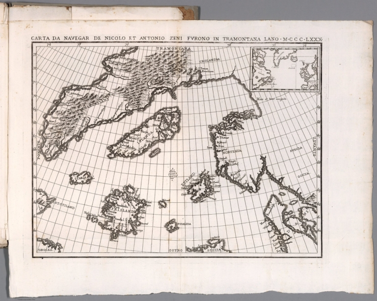
Carta Da Navegar De Nicolo et Antonio Zeni Fvrono In Tramontana Lano M.CCC.LXXX
Publisher:
Tipografia Picotti
Publisher Location:
Venezia
Type:
Book Map
Obj Height cm:
28
Obj Width cm:
36
Scale 1:
None shown
Note:
The Zeno map purports to illustrate the voyages of the author's ancestor and his brother at the end of the 14th century, first appeared in Venice in the year 1558 as a part of a small book that contained accounts of voyages in the North Atlantic and westward to the shores of America. It is, however, a fictitious map based upon Olaus Magnus's Carta marina, along with other 16th century maps, and was probably created to give Venice, the author's native city, the credit for discovering America more than a century ahead of Columbus. Estotiland (said to be inhabited by people of European lineage, but having its own language; it is perhaps Labrador) and Drogeo (perhaps Newfoundland) on this map appear to represent the eastern coast of America. Frisland, originally referred to Iceland, but was added along with Iceland on this map. It appeared on subsequent maps for the next hundred years. It may refer to the Faroe Islands. The meridians are marked.
Region:
North Atlantic Ocean
Subject:
Exploration
Full Title:
Carta Da Navegar De Nicolo et Antonio Zeni Fvrono In Tramontana Lano M.CCC.LXXX. (inset). (to accompany) Sulle antiche mappe idro - geografiche lavorate in Venezia.
List No:
11171.005
Series No:
5
Engraver or Printer:
Zeno, Antonio
Publication Author:
Zurla, Placido, 1769-1834
Pub Date:
1818
Pub Title:
Sulle antiche mappe idro - geografiche lavorate in Venezia commentario del P. Ab. D. Placido Zurla. In Venezia Nella Tipografia Picotti MDCCCXVIII (1818).
Pub Note:
An ancient hydro-geographical work in Venice, by Placido Zurla in 96 pages of descriptive text, and three uncolored maps. Including: 1- Abbozzo della mappa dei viaggi di Marco Polo ... 2- Carta Da Navegar De Nicolo et Antonio Zeni Fvrono In Tramontana Lano M.CCC. LXXX. 3- Abbozzo Del Mappamondo Di F: Mauro Camaldolese Cosmografo Incomparabile alla Meta del Sec. XV. Text and maps includes: Marco Polo's travels, map showing his exploration routes in East Asia, also shows northern part of America, Sierra Nevada, etc., voyages of Nicolo and Antonio Zeno in North Atlantic, map showing North Atlantic, Greenland, Iceland and Lapland, etc., and the last map is a circular planisphere map of the world, made by Fra Mauro.
Pub List No:
11171.000
Pub Type:
Exploration Book
Pub Maps:
3
Pub Height cm:
30
Pub Width cm:
23
Image No:
11171005.jp2
Authors:
Zurla, Placido, 1769-1834; Niccolo�� Zeno