COLLECTION NAME:
David Rumsey Historical Map Collection
Record
Author:
Santarem, Manuel Francisco de.
Author:
Mauro, Fra
Date:
1450
Short Title:
Mappemonde Pl. 6
Type:
Separate Map
Obj Height cm:
52
Obj Width cm:
107
Scale 1:
None shown
Note:
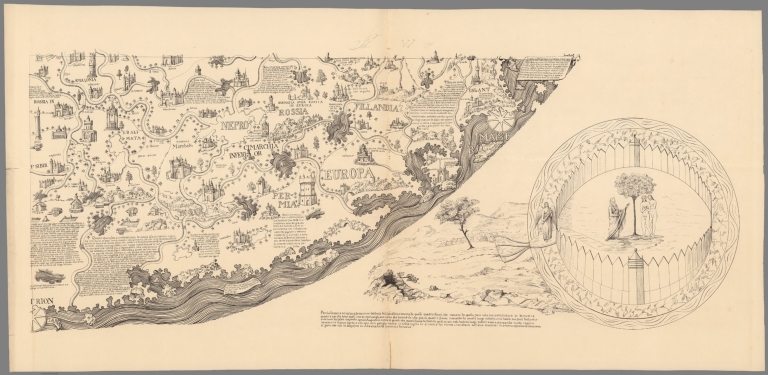
Large circular planisphere on 6 sheets, 85x107 or smaller. Title from sheet 5. Reproduced and printed for the first time at the size of the original with all the legends and notations by Viscount of Santarém in 1854. The original 1450 map was fully described and reproduced in manuscript for the first time by William Frazer in 1804, Manuscript on vellum, BL Add. MS 1126. This was deposited at the British Museum in 1807 by William Vincent, dean of Westminster. Vincent wrote a short account of this process in 1807 in his "The Commerce and Navigation of the Ancients in the Indian Ocean," 2 vols. London: Cadell and Davies, 1807, in an appendix = 2:661–79. Matthew Edney states "Santarém took his facsimile from a tracing of Frazer’s manuscript at the BM, as indicated by the placement of Eden in the lower-right corner, rather than in the lower-left where it actually sits: see: Cattaneo, Angelo. “L’Atlas del visconte de Santarém: Una storia culturale europa tra erudizione orientalismo e colonialismo,” in “A história da cartografia na obra do 2.º visconde de Santarém. Exposição cartobibliográfica, 24 de Novembro de 2006 a 10 de Fevereiro de 2007”, edited by João Carlos García, and Maria Joaquina Feijoo, 17–49. Lisbon: Biblioteca Nacional, 2006." Fra Mauro's map was also reproduced by Placido Zurla in II Mappamondo di Fra Mauro Camaldolese, 1818 in Venice ( see our copy), and later again by Santarem in his facsimile Atlas of 1849, "Atlas de Vicomte de Santarem," see lower left sheet 5. Unusual for medieval European maps, it is oriented with South at the top (Indian Ocean, top left; Mediterranean, right center) and so meticulously drawn and full of detail and legends that it has been described as a “medieval cosmography of no small extent, a conspectus of 15th century geographical knowledge cast in medieval form.” The coasts are drawn in a style recalling that of nautical charts. Includes 4 insets at each corner, numerous note boxes on the map and explanatory text at the margins. Shows place names, rivers, mountains, lakes, etc. Landmarks shown pictorially. Text and place names in Italian, publication information in French. Relief shown pictorially.
World Area:
World
Full Title:
Mappemonde dress es en 1450, par Fra Mauro cosmographe Venetien. Par order d'Alphonse V. Roide Portugal. Publiee pour la premiere fois de la grandeur de l'original avec toutes les Legendes par Le Vicomte de Santarem, 1854. J. J. Feuquieres, lith. Schwaerzle Sculp. Pl. VI.
List No:
11177.006
Page No:
6
Series No:
6
Publication Author:
Santarem, Manuel Francisco de.
Publication Author:
Mauro, Fra
Pub Date:
1854
Pub Title:
Mappemonde dress es en 1450, par Fra Mauro cosmographe Venetien. Par order d'Alphonse V. Roide Portugal. Publiee pour la premiere fois de la grandeur de l'original avec toutes les Legendes par Le Vicomte de Santarem, 1854. J. J. Feuquieres, lith. Schwaerzle Sculp.
Pub Note:
See note field above.
Pub List No:
11177.000
Pub Type:
Separate Map
Pub Maps:
6
Pub Height cm:
250
Pub Width cm:
214
Image No:
11177006.jp2
Authors:
Mauro, Fra; Santarem, Manuel Francisco de.