COLLECTION NAME:
David Rumsey Historical Map Collection
Record
Author:
Berthrong, I. P.
Author:
United States. General Land Office.
Date:
1918
Short Title:
Map of the Territory of Hawaii
Publisher:
U.S. Geological Survey
Publisher Location:
Washington:
Type:
Separate Map
Obj Height cm:
56
Obj Width cm:
84
Scale 1:
760,320
Note:
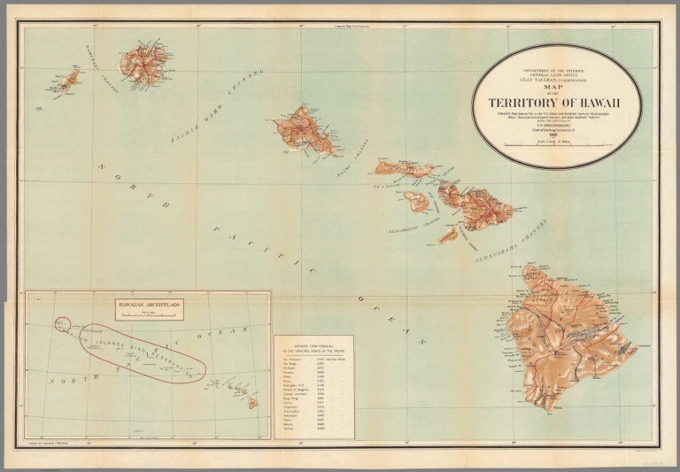
Color map. Relief shown by shading and spot heights. Shows administrative boundaries, cities and towns. Includes table of distances "from Honolulu to the principal ports of the Pacific."
State/Province:
Hawaii
Full Title:
Department of the Interior General Land Office, Clay Tallman, Commissioner. Map of the Territory of Hawaii compiled from data on file in the U.S. Coast and Geodetic Survey: Hydrographic Office: Hawaiian Government Surveys, and other authentic sources under the direction of I. P. Berthrong, Chief of Drafting Division, G.L.O. 1918. Compiled and lettered by I. P. Berthrong. Printed in U.S. by Geological Survey. (inset) Hawaiian Archipelago ca 1:9,500,000.
List No:
11522.000
Publication Author:
Berthrong, I. P.
Publication Author:
United States. General Land Office.
Pub Date:
1918
Pub Title:
Department of the Interior General Land Office, Clay Tallman, Commissioner. Map of the Territory of Hawaii compiled from data on file in the U.S. Coast and Geodetic Survey: Hydrographic Office: Hawaiian Government Surveys, and other authentic sources under the direction of I. P. Berthrong, Chief of Drafting Division, G.L.O. 1918. Compiled and lettered by I. P. Berthrong. Printed in U.S. by Geological Survey. (inset) Hawaiian Archipelago ca 1:9,500,000.
Pub Note:
See note field above.
Pub List No:
11522.000
Pub Type:
Separate Map
Pub Height cm:
56
Pub Width cm:
84
Image No:
11522000.jp2
Authors:
Berthrong, I. P.; United States. General Land Office.