COLLECTION NAME:
David Rumsey Historical Map Collection
Record
Author:
Imray, James
Author:
Hewett
Author:
Slater
Date:
1852
Short Title:
A new chart of the East Coast of England and Scotland
Publisher:
James Imray
Publisher Location:
London
Type:
Chart Map
Obj Height cm:
65
Obj Width cm:
96
Scale 1:
6,000,000
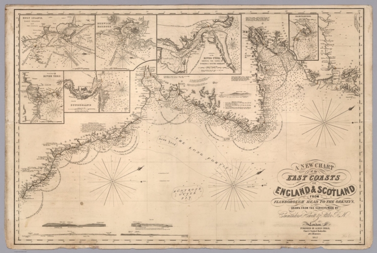
Note:
Navigation chart of the East Coast of England and Scotland with 5 insets, 4 profile views, and notes. Showing all the harbors, rivers, bays, roads, rocks, sands, buoys, beacons, sea-marks, depths of water, latitude, bearings and the course of the principal tracts and their distances from place to place in English miles. Includes notes, describing the setting and flowing of the tides; with directions for the knowing of any place, and how to harbor a ship. Depths shown by soundings. "Price 5s."
Country:
England
Country:
Scotland
Subject:
Nautical Charts
Full Title:
A new chart of the East Coast of England and Scotland from Flamborough Head to the Orkneys. Drawn from the survey of Commanders Hewett and Slater R. N. London : Published by James Imray Navigation Warehouse and Nautical Academy, 102, Minories. (5 insets) (to accompany) Imray's New North Sea and Coasting Pilot.
List No:
11518.004
Series No:
4
Publication Author:
Imray, James
Pub Date:
1852
Pub Title:
Imray's New North Sea and Coasting Pilot, containing the following charts: viz:- No. 1. - The River Thames ..; No. 2. - The East Coast of England...; No. 3. - The East Coast of England and Scotland...; No. 4. The North Sea... London : Published by James Imray Navigation Warehouse and Nautical Academy, 102, Minories.
Pub Note:
Rare navigation charts of the British East Coast and North Sea, with four charts to form an atlas, first and last chart backed in blue paper, title pasted to the front cover. Showing all the harbors, rivers, bays, roads, rocks, sands, buoys, beacons, sea-marks, depths of water, latitude, bearings and the course of the principal tracts and their distances from place to place in English miles. Includes notes, describing the setting and flowing of the tides; with directions for the knowing of any place, and how to harbor a ship. Depths shown by soundings. "Price twelve Shillings." Maps are priced individually.
Pub List No:
11518.000
Pub Type:
Chart Atlas
Pub Maps:
4
Pub Height cm:
67
Pub Width cm:
51
Image No:
11518004.jp2
Authors:
Imray, James; Hewett; Slater