COLLECTION NAME:
David Rumsey Historical Map Collection
Record
Author:
Fer, Nicolas de, 1646-1720
Date:
1693
Short Title:
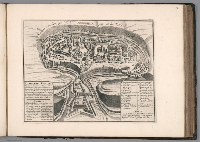
Kamieniec Podolski : Ville forte des Estats de Pologne
Publisher:
Chez l'Auteur (De Fer)
Publisher Location:
Paris
Type:
View
Obj Height cm:
21
Obj Width cm:
27
Scale 1:
None shown
Note:
Engraved bird's eye view of the city of Kamianets-Podilskyi, in western Ukraine. Shows rivers, canals, bridges, forests, buildings and landmarks. Relief shown pictorially. Includes explanatory text and numbered key to the important sites on the map.
Reference:
Phillips, A List of Geographical Atlases in the Library of Congress, 517a, Shirley, T,Fe-1c.
Country:
Ukraine
City:
Kamianets-Podilskyi (Ukraine)
Subject:
Military
Subject:
Historical
Full Title:
Kamieniec Podolski. Ville Forte des Estats de Pologne, et de la Haute Podolie avec titre d'Evêché et de Palatinat ... A Paris. Chez Sr. De Fer ... 1693. 2nde. partie. (to accompany) Les forces de l'Europe ... Le tout recueilli par les soins du Sr. de Fer ... Seconde partie. A Paris, chez l'Auteur dans l'Isle du palais. M. DC. LXXXXIII (1693).
List No:
11668.046
Page No:
II.14
Series No:
46
Publication Author:
Fer, Nicolas de, 1646-1720
Pub Date:
1696
Pub Title:
Les forces de l'Europe, ou Description des principales villes, avec leurs fortifications : Dessinees par les meilleurs ingenieurs; particulierement celles qui sont sous la domination de la France, dont les plans ont estee levez par Monsieur de Vauban, ... & aussi la description de tous les instrumens servans aa la fortification, aa l'attaque & deffense des places, ensemble ceux qui servent pour l'artillerie, la maniere de dresser un camp devant une ville assiegee. Le tout recueilli par les soins du Sr. de Fer ... pour l'usage de Monseigneur le duc de Bourgogne. A Paris, chez l'auteur dans l'Isle du palais. M. DC. LXXXXIII (1693). Avec privilege du Roy.
Pub Note:
One volume in 8 parts. Each part has separate title-page, dated 1693-1696, by Nicholas De Fer. Title pages to each part printed in red and black. Includes engraved dedication to the Duc de Bourgogne “Introduction a la Fortification dediee a Monseigneur le Duc Bourgogne … 1693.”, and Armorial bookplate of "The Right Hon.ble Algernon Capell, Earl of Essex, Viscount Maldon, and Baron Capell of Hadham," dated 1701 on verso. Letter press table of contents for parts 1-5 and contemporary manuscript listing of parts 5-8 on verso. Allegorical frontispiece engraved by Schoonebeck following the part 2 title page. Atlas includes 184 uncolored engraved maps, plans and views, one folded, some with corresponding letterpress or engraved text. Showing fortifications of European cities in France, Germany and the Netherlands, also includes other regions, including Malta, Constantinople,Tripoli, Batavia and map of Quebec, which is bound in part 5 as map 23. The Battle of Quebec was fought in October 1690 between the colonies of New France and Massachusetts Bay. In 1690, Sir William Phips was appointed major-general by Massachusetts to command an expedition against French Acadia. He sailed with seven vessels carrying a 450-strong provincial "Foot Regiment", and Port Royal surrendered on 21 May. Atlas bound in contemporary calf, with raised decorated spine, with title “Forces del Evrope.” Nicolas De Fer, a French Publisher, engraver, geographer and cartographer. He made maps of places in Europe and North America, including New Spain,[7] places fortified by Vauban, the Low Countries, and the War of the Spanish Succession. In 1698, de Fer published a map of North America, which included a depiction of beavers building dams near Niagara Falls.
Pub List No:
11668.000
Pub Type:
Regional Atlas
Pub Type:
Military Atlas
Pub Maps:
184
Pub Height cm:
29
Pub Width cm:
39
Image No:
11668046.jp2
Authors:
Fer, Nicolas de, 1646-1720