COLLECTION NAME:
David Rumsey Historical Map Collection
Record
Author:
Viele, Egbert L.
Date:
1865
Short Title:
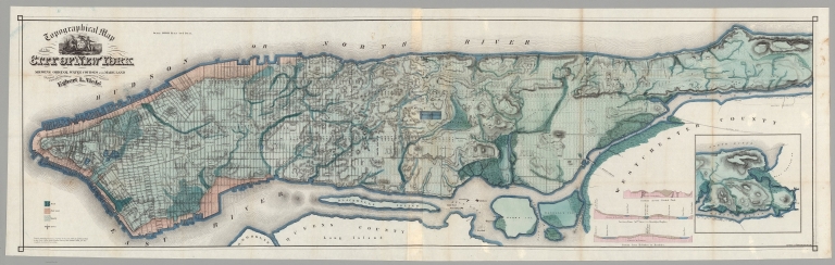
Topographical Map of the City of New York. Showing Original Water Courses and Made Land.
Publisher:
Robert Craighead, Printer
Publisher Location:
New York
Type:
Atlas Map
Obj Height cm:
47
Obj Width cm:
160
Scale 1:
12,000
Note:
This is a rare variant of Viele's New York City map. It is printed on thin paper and folded into the rear of a small booklet with an essay by Viele explaining the map and its construction and the topography of New York City. The map shows all the original water courses of Manhattan Island, with the street grid superimposed on top. Also, three different kinds of land are shown: Marsh, Made Land, and Meadow. Sewer lines are indicated. This map differs in the title from the more common version issued with the Report on the Sanitary Conditions in New York (see our 3723.000)/ In 1874 Viele reissued the map in larger format as the Topographical Atlas of the City of New York (see our copy).
Reference:
Haskell 1132; Stokes vol 3, p.777-778.
State/Province:
New York
City:
New York (N.Y.)
Subject:
Data Visualization
Subject:
Health; Disease
Full Title:
Topographical Map of the City of New York. Showing Original Water Courses and Made Land. Prepared Under the direction of Egbert L. Viele, Topographical Engineer. Entered ... 1865 by Egbert L. Viele ... New York. Ferd. Mayer & Co. Lithographers, 96 Fulton St. N.Y. (with 1 inset map and 3 profiles).
List No:
10156.004
Series No:
4
Publication Author:
Viele, Egbert L.
Pub Date:
1865
Pub Title:
The Topography and Hydrology of New York. By Egbert L. Viele.
Pub Reference:
Haskell 1132; Stokes vol 3, p.777-778.
Pub Note:
See note field above.
Pub List No:
10156.000
Pub Type:
City Atlas
Pub Maps:
1
Pub Height cm:
24
Pub Width cm:
15
Image No:
10156004.jp2
Authors:
Viele, Egbert L.