COLLECTION NAME:
David Rumsey Historical Map Collection
Record
Author:
Philip, George
Date:
1905
Short Title:
The North Sea and the Baltic - Physical
Publisher:
George Philip & Son, Ltd.
Publisher Location:
London
Publisher:
London Geographical Institute; Liverpool: Philip, Son & Nephew, Ltd.
Publisher Location:
London
Type:
Atlas Map
Obj Height cm:
32
Obj Width cm:
44
Scale 1:
12,900,000
Note:
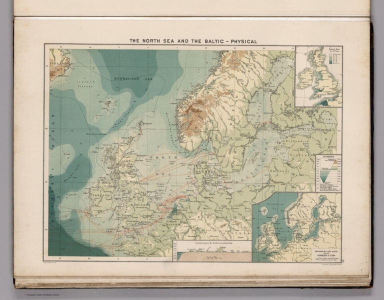
Color physical map of North Sea and Baltic Sea. Relief shown by gradient tints and spot heights. Depths shown by bathymetric tints and soundings. Showing depth of the sea, the height of the land, telegraph cables, direction of tidal streams and Co-tidal lines.
Region:
North Sea Region
Region:
Baltic Sea Region
Subject:
Physical
Subject:
Communications
Full Title:
The North Sea and the Baltic - Physical. George Philip & Son, Ltd. The London Geographical Institute. (to accompany) Philips' Mercantile Marine Atlas. Second Edition ... 1905. (insets) Spring rise of the tides. (with) North Sea and the Baltic, showing visibility of land.
List No:
0724.032
Page No:
plate 23
Series No:
32
Engraver or Printer:
London Geographical Institute
Engraver or Printer:
Philip, Son & Nephew
Publication Author:
Philip, George
Pub Date:
1905
Pub Title:
Philips' Mercantile Marine Atlas. A Series Of 30 Plates Containing Over 100 Charts & Plans, With Tables Of 8,600 Distances Between Ports, National & House Flags, Lists Of British & United States Consulates, And Complete Index Of 20,000 Ports, &c. Specially Designed For Merchant Shippers, Exporters & Ocean Travellers And For General Use. Edited By George Philip, F.R.G.S. Second Edition. London: George Philip & Son, Ltd., The London Geographical Institute, 32 Fleet Street, E.C. Liverpool: Philip, Son & Nephew, 45 To 51 South Castle Street. 1905. All Rights Reserved. Entered at Stationers Hall.
Pub Note:
2nd edition, 1905 Philip's Philips' Mercantile Marine Atlas. Edited by George Philip. Published by George Philip & Son and London Geographical Institute in 1905. Maps are double page, printed in full color, including general maps and diagrams, navigation charts and physical maps. Showing mail routes, steamship routes, distances, cities, towns, populations, naval stations, cables, light houses, navigable waters, canals, roads and railroads. Depth shown by gradient tints and soundings. Atlas also includes statistical summary: table of distances, list of British and American consulates, Foreign money values, and index. It's bound in half leather dark blue cloth covered boards with "Philips' Mercantile Marine Atlas Of The World" embossed on the front cover and the spine in gilt.
Pub List No:
0724.000
Pub Type:
World Atlas
Pub Maps:
28
Pub Height cm:
54
Pub Width cm:
41
Image No:
0724032.jp2
Authors:
Philip, George