COLLECTION NAME:
David Rumsey Historical Map Collection
Record
Author:
Hull-House (Chicago, Ill.)
Author:
Addams, Jane, 1860-1935
Author:
Kelley, Florence, 1859-1932
Date:
1895
Short Title:
Wage Map No. 1 Wage Map No. 2 Wage Map No. 3 Wage Map No. 4
Publisher:
Thomas Y. Crowell & Co.
Publisher Location:
New York
Type:
Book Map
Obj Height cm:
32
Obj Width cm:
110
Scale 1:
None shown
Note:
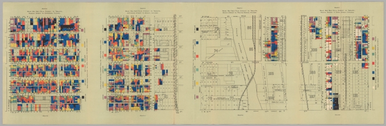
Crouch: "The Hull House maps were groundbreaking in both sociology and cartography, pioneering the method of mapping "social and demographic characteristics of a population within a geographical area" over time to initiate social change (Deegan). The maps document socioeconomic data from slum neighbourhoods in the midst of immigration into the United States. When impoverished Europeans fled to America in search of financial security, the rapid influx and lack of housing that awaited them led to atrocious conditions of decay and overcrowding in industrial centres. Hull House was set up to counter this trend. It was opened by Jane Addams and Ellen Gates Starr in 1889, two social reformers and activists who decided to start the house after visiting a similar institution, Toynbee Hall, in Britain. Settlement houses were charity centres which aimed to alleviate poverty and encourage social diversity by housing middle class volunteers amongst working class recipients. Hull House acted as a residential facility as well as a community centre for newly arrived immigrants. A place where integration into American society was taught through various skills and language classes, Hull House illustrated the burgeoning social concerns circulating throughout the late nineteenth and early twentieth centuries. The Hull House Maps and Papers project was led by Florence Kelley, a researcher and advocate who was particularly interested in social and working conditions. As well as the Hull House project, she also worked on the report of the smallpox epidemic in Chicago in 1893, and helped enforce the provisions of the Illinois Factory Inspection Law (she was the first female factory inspector in America). The team based at Hull House collected data by visiting and questioning the inhabitants of the neighbourhood, helped by four workers from the Bureau of Labor (the research was part of a wider project on slums commissioned by Congress in 1892). The book eventually produced was a collection of essays on topics ranging from labour unions to the function of art in the community. The highlights, however, were the maps, inspired by Charles Booth's poverty maps of London. There are two sets of maps covering the same four sections of Chicago: one showing the nationality of the inhabitants of each buildings, and one showing the weekly household income. The different nationalities and income bands are represented by different colours. The maps can be juxtaposed to show both the variety of people emigrating to America, and also how successful they were. Hull House then used these maps as the basis of discussion for future projects. For example, by comparing the first wage and nationality maps showing Halstead Street to Jefferson, it is clear that the strips of English-speaking people along De Koven and West 12th tended to earn in the highest income bracket, above 20 dollars per week, suggesting the importance of the language lessons offered by the House. The maps are also an important example of the growth in research work done by women in centres like Hull-House, while social science as a discipline was still forming in traditional academic institutions. They were "the single most important work by American women social scientists before 1900" (Kish Sklar)."
City:
Chicago (Ill.)
Subject:
Data Visualization
Subject:
Thematic
Full Title:
Wage Map No. 1. Polk Street to Twelfth, Halsted Street to Jefferson, Chicago. Wage Map No. 2. Polk Street to Twelfth, Jefferson Street to Beach, Chicago. Wage Map No. 3. Polk Street to Twelfth, Beach Street to Pacific Avenue, Chicago. Wage Map No. 4. Polk Street to Twelfth, Pacific Avenue to State Street, Chicago.
List No:
10165.002
Series No:
2
Publication Author:
Hull-House (Chicago, Ill.)
Publication Author:
Addams, Jane, 1860-1935
Publication Author:
Kelley, Florence, 1859-1932
Pub Date:
1895
Pub Title:
Maps and papers, a presentation of nationalities and wages in a congested district of Chicago, together with comments and essays on problems growing out of the social conditions
Pub Note:
Prefatory note by Jane Addams; Map, notes and comments by Agnes Sinclair Holbrook; The sweating system, by Florence Kelley; Wage earning children; by Florence Kelley and Alzina P. Stevens; Receipts and expenditures of cloakmakers in Chicago, by Isabel Eaton; The Chicago ghetto, by Charles Zeubin; The Bohemian people in Chicago, by Josefa Humpal Zeman; Remarks upon the Italian colony in Chicago, by Alessandro Mastro-Valerio; The Cook county charities, by Julia C. Lathrop; Art and labor, by Ellen Gates Starr; The settlement as a factor in the labor movements, by Jane Addams; Hull House; a social settlement.
Pub List No:
10165.000
Pub Type:
Geography Book
Pub Maps:
2
Pub Height cm:
22
Pub Width cm:
15
Image No:
10165002.jp2
Authors:
Hull-House (Chicago, Ill.); Addams, Jane, 1860-1935 ; Kelley, Florence, 1859-1932