COLLECTION NAME:
David Rumsey Historical Map Collection
Record
Author:
Montresor, John, 1736-1799
Date:
1768
Short Title:
Map of Nova Scotia or Acadia with the Islands of Cape Breton and St. John's
Publisher:
A. Dury
Publisher Location:
London
Type:
Separate Map
Obj Height cm:
100
Obj Width cm:
139
Scale 1:
390,000
Note:
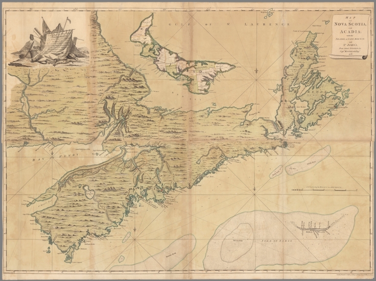
Engraved hand colored map, published on 8 sheets, depicts Nova Scotia, Cape Breton and St. John's, now prince Edward Island and part of New Brunswick. Shows place names, forts, and administrative boundaries on St. John's Island. Relief shown pictorially and by hachures. Depths shown by soundings. Prime meridian is Ferro. Includes pictorial inscription to John Manners in upper left corner. Incorporates the recent surveys of St. John's Island (now Prince Edward Island) by Samuel Holland.
Reference:
Kershaw #793 (2nd state, with parish divisions added and plots numbered on St. John Island). Phillips, Maps of America, p. 624 (the Faden edition of 1777). Sellers & Van Ee, Maps and Charts of North America and the West Indies, #312.
County:
Nova Scotia
County:
Prince Edward Island
Subject:
Nautical Charts
Full Title:
Map of Nova Scotia or Acadia with the Islands of Cape Breton and St. John's. from actual surveys, by Captn. Montresor, engir., 1768. London; Printed & sold by A. Dury, 1768.
List No:
13078.000
Publication Author:
Montresor, John, 1736-1799
Pub Date:
1768
Pub Title:
Map of Nova Scotia or Acadia with the Islands of Cape Breton and St. John's. from actual surveys, by Captn. Montresor, engir., 1768. London; Printed & sold by A. Dury, 1768.
Pub Note:
Michael Buehler:"A monumental, separately-issued map of the Canadian Maritimes, by the most accomplished military engineer in Great Britain’s North American service. The years between the end of the French and Indian War and the start of the Revolution were extremely fertile for the mapping of North America, as the British administration sought to understand millions of square miles of newly-acquired territory. A region of great interest was the Canadian Maritimes, strategically located in proximity to both the St. Lawrence River and the sea lanes to Britain’s American colonies. This mammoth map by Captain John Montresor is printed on four sheets and depicts Nova Scotia, Cape Breton, St. John’s Island (now Prince Edward) and adjacent portions of New Brunswick. “[The map] shows parishes on Prince Edward Island, administrative subdivisions within each parish, bays and inlets, and numerous place-names. Most of the interior in Nova Scotia and New Brunswick is filled in with imaginary hills and vegetation. Shown in greater detail are the areas at the head of the Bay of Fundy and along the southeast coast of Nova Scotia. Includes towns, roads, forts, farms, fields, distances between points of interest, and anchorages and navigational hazards along the coast. Soundings are given around Sable Island, along the Atlantic Coast of Nova Scotia, and in “Green Bay” (Baie Verte).” (Sellers & Van Ee, #312.) Of particular importance are the numerous forts scattered around the periphery, including Fort Anapolis, Halifax, and Louisbourg. As noted by Sellers & Van Ee, with the exception of St. John`s Island and the river systems draining into the Bay of Fundy, the map is striking for the lack of detail in interior areas. (This is the second state of the map, with parish divisions and plot numbers on St. John’s Island. The map was later re-issued in 1777 in Faden’s North American Atlas. Montresor was a British military engineer with a long, varied and almost unbelievably accomplished career in the American Colonies, beginning with service during the French and Indian War and not concluding until 1778, by which point he was Chief Engineer in North America. His time in Canada during the French and Indian War must have yielded much material for this map: He was present at the 1758 siege and capture of Louisbourg, and soon thereafter was sent to scout Cape Breton’s Bras d’Or Lakes. Following the 1759 conquest of Quebec he helped compile maps based on Joseph Peach’s survey of the St. John’s River in New Brunswick. (Hornsby, Surveyors of Empire, p. 38) We learn from Montresor’s Journals that he arranged for the engraving and publication of this map, along with a number of others, during a six-month leave in England from late 1766 to mid-1777: “May 1st [1767]. Constantly attending at the 2 Engravers to assist them in the Executions of the severnl [sic] Draughts I have given them to Engrave for me vizt one of Nova Scotia, one of the Province of New York, one of Canada from the first Island to Montreal and one of the City of New York and Environs with the Bosen [?] Harbor and Channel from the Hook.” (Journals, p. 392) The map’s subtitle-“From Actual SURVEYS, by Captn. MONTRESOR, Engir.”-suggests strongly that the map was based entirely on Montresor’s own surveys, or ones made under his direction, especially as no other contributors are cited. This is however untrue: The depiction of St. John’s Island is entirely based on surveys conducted and administrative divisions established by Samuel Holland in 1764-65, and that of the St. John’s River was likely based on the Joseph Peach survey mentioned above. Further, this writer knows of no evidence that, Cape Breton aside, Montresor spent any significant time in the Canadian Maritimes. This would not have been the first time Montresor presented Holland’s work as his own: in the early 1760s he had been punished for effacing the other man’s name from a map of the St. Lawrence being prepared for presentation to William Pitt! (Hornsby, p. 29) For all of Montresor’s flaws-and they practically leap from the pages of his Journals-he deserves to be remembered and appreciated for his immense talents, energy and contributions to the British conquest and mapping of North America."
Pub List No:
13078.000
Pub Type:
Separate Map
Pub Height cm:
100
Pub Width cm:
131
Image No:
13078000.jp2
Authors:
Montresor, John, 1736-1799