COLLECTION NAME:
David Rumsey Historical Map Collection
Record
Author:
Vuillemin, Alexandre
Date:
1861
Short Title:
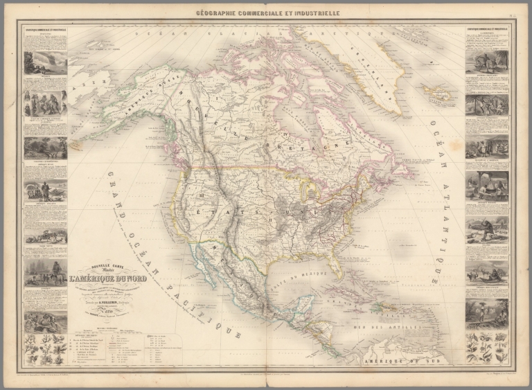
Pl. 15. Nouvelle carte illustree de l'Amerique du Nord
Publisher:
Francois Delarue, Bulla Freres
Publisher Location:
Paris
Publisher:
Mangeon
Publisher Location:
Paris
Type:
Atlas Map
Obj Height cm:
61
Obj Width cm:
84
Scale 1:
13,500,000
Note:
Engraved outline hand color map. Including 16 vignettes views showing indigenous people in North America and 2 sections of fruits and plants in panels at sides. Map shows Russian America, Utah & New Mexico extending to the Rocky Mountains, Oregon, Northwest and Indian Territories, early discoveries, including a reference to Alvaro Nunez in Texas in 1528, Cabrillo's discovery of the Pacific in 1548, Francis Drake, Lewis & Clark and Edwin James. Includes legend, tables, color coded table of European colonies in the region and notes.
World Area:
North America
Country:
United States
Country:
Canada
Country:
Mexico
Subject:
Administrative and political divisions
Subject:
Agriculture
Subject:
Mining
Full Title:
Geographie commerciale et industrielle : Nouvelle carte illustree de l'Amerique du Nord : Indiquant Les Grandes Divisions Physiques, La Distribution Geographique Des Vegetaux Et Mineraux ... Dressee par A. Vuillemin. Gravee par Langevin. Paris, Chez Fatout, Editeur. 1861. Grave sur acier, Grave: la Topographie par Gerin, le trait au burin par F. Lefevre. Les illustrations dessinees par A. Testard et gravees par Guensu. Imprime par Mangeon. Paris. (to accompany) Atlas illustre de geographie commerciale et industrielle.
List No:
13376.019
Page No:
Pl. 15
Series No:
19
Engraver or Printer:
Langevin
Engraver or Printer:
Gerin
Engraver or Printer:
Lefevre, F.
Engraver or Printer:
Testard, A.
Engraver or Printer:
Guensu
Publication Author:
Vuillemin, Alexandre
Pub Date:
1863
Pub Title:
Atlas illustre de geographie commerciale et industrielle : presentant les grandes divisions physiques, la distribution geographique des vegeaux et des mineraux, les villes industrielles et usines importantes, les ports commerciaux, les chemins de fer et les parcours des paquebots a vapeur ... Dresse par A. Vuillemin, Geographe. Paris : Francois Delarue, Bulla Freres.
Pub Note:
Atlas of the world commercial and Industrial geography representing major political and administrative divisions, geographical distribution of plants and minerals. Consists of 16 maps dated 1861 and 1863, published by Francois Delarue, Bulla Freres. Maps include vignettes depicting the different aspects of the regions, statistical tables and legend. Showing political and administrative divisions, capitals, industrial cities and major plants, commercial ports, railways and steamship routes, discoveries and travel made from the 9th century to the present day, the European colonies in different parts of the world, population, the Territorial Area, the Industrial Products, fortress, the navy and the dominant religion of each country. Relief shown by hachures and pictorially. Bound in red paper covered boards with title "Atlas de geographie commerciale et industrielle apprpuve par S. EX. Le Ministre de l'Instruction Publique" in gilt on cover.
Pub List No:
13376.000
Pub Type:
World Atlas
Pub Maps:
16
Pub Height cm:
66
Pub Width cm:
46
Image No:
13376019.jp2
Authors:
Vuillemin, Alexandre
