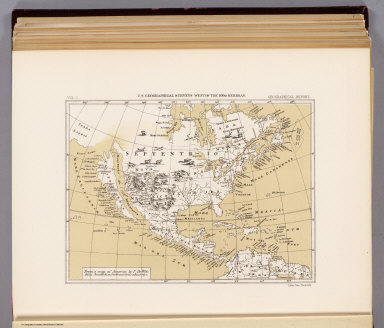
Detail View: David Rumsey Historical Map Collection: America, about 1670.
|
Author:
|
Wit, Frederik de
|
|
Date:
|
1889
|
|
Short Title:
|
America, about 1670.
|
|
Publisher:
|
U.S.
|
|
Publisher Location:
|
Washington
|
|
Type:
|
Atlas Map
|
|
Obj Height cm:
|
16
|
|
Obj Width cm:
|
21
|
|
Scale 1:
|
65,000,000
|
|
Note:
|
Color lithograph reproduction. Relief shown pictorially. Shows California as an island. As pl. XXXV in list of plates.
|
|
World Area:
|
North America
|
|
Full Title:
|
From a map of America by F. De Wit. Folio, Amsterdam, without date, about 1670. Julius Bien, Photo-lith. U.S. Geographical Surveys West of the 100th Meridian. (1889)
|
|
List No:
|
2220.038
|
|
Page No:
|
v. 1 opp. 509
|
|
Series No:
|
42
|
|
Engraver or Printer:
|
Bien, Julius
|
|
Publication Author:
|
Wheeler, G.M.
|
|
Pub Date:
|
1875
|
|
Pub Title:
|
Report upon United States Geographical Surveys West of the One Hundredth Meridian, in charge of Capt. Geo. M. Wheeler, Corps of Engineers, U.S. Army ... In seven volumes and one supplement, accompanied by one topographic and one geologic atlas.
|
|
Pub Reference:
|
Wheat v. 5, p 338-342; Karrow "George M. Wheeler ..." in Koepp Exploration and Mapping of the American West.
|
|
Pub Note:
|
These seven text volumes were published from 1875 to 1889. They consist the final, monumental report of Wheeler's Survey. The first volume, Geographical Report, contains much valuable information on the general history of western U.S. mapping and specific details on the sources of the Survey's map sheets. The Topographic and Geologic Atlas were issued separately. Bound in linen with title, date, volume number and topic on the spine.
|
|
Pub List No:
|
2220.000
|
|
Pub Type:
|
Exploration Book
|
|
Pub Maps:
|
27
|
|
Pub Height cm:
|
30
|
|
Pub Width cm:
|
24
|
|
Image No:
|
2220038
|
|
Download 1:
|
|
|
Download 2:
|
|
|
Authors:
|
Wit, Frederik de
|
|
Collection:
|
Rumsey Collection
|