COLLECTION NAME:
David Rumsey Historical Map Collection
Record
Author:
Ireland, Railway Commissioners
Author:
Griffith, Richard John (1784-1878)
Date:
1855
Short Title:
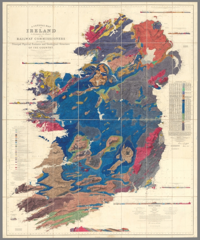
Composite: Sheets 1-6. A General Map Of Ireland.(Geologically colored).
Publisher:
Hodges & N. Smith
Publisher Location:
Dublin
Publisher Location:
London
Publisher:
Longman & Co.
Publisher Location:
Dublin
Publisher Location:
London
Type:
Composite Map
Obj Height cm:
192
Obj Width cm:
156
Scale 1:
253,440
Note:
1st ed. was 1836/7; Signed by Griffith & Larcom (perhaps printed signatures). Colored Geologically, showing political boundaries and railroads. Originally published to accompany the Atlas to accompany the second Report of the Railway Commissioners, 1837. Map is in six sheets, each dissected into 8 sections. Full color. Sheets have marbled end papers.
Reference:
Robinson p.118-120.
Country:
Ireland
Subject:
Railroad
Subject:
Geology
Full Title:
Composite map of) Sheets 1-6. A General Map Of Ireland to Accompany the Report of the Railway Commissioners shewing the Principal Physical Features and Geological Structure Of The Country. Constructed In 1836 And Engraved In 1837-8. The Geology Revised And Improved In 1855. Published And Sold By Hodges & Smith, Dublin, And Longman & Co., London. With whom Copies coloured Geologically are deposited. Price Twenty Shillings Plain ...(Geologically colored).
List No:
10485.007
Series No:
7
Publication Author:
Ireland, Railway Commissioners
Publication Author:
Griffith, Richard John (1784-1878)
Pub Date:
1855
Pub Title:
A General Map Of Ireland to Accompany the Report of the Railway Commissioners shewing the Principal Physical Features and Geological Structure Of The Country. Constructed In 1836 And Engraved In 1837-8. The Geology Revised And Improved In 1855. Published And Sold By Hodges & Smith, Dublin, And Longman & Co., London. With whom Copies coloured Geologically are deposited. Price Twenty Shillings Plain ...
Pub Note:
"Each sheet initialled and dated in lower right hand margin, conceivably by ‘RG’ and, where not trimmed, the dates read August – November 1864. The handwriting seems similar to Griffiths’ as it appears in his dated signature; for example, compare the ‘A’ of August and April. Each sheet was evidently carefully checked and initialled as and when it was coloured. The imprint suggests that geological colouring was normally done in London, and that only a limited number were available for sale, with the implication that there was nobody in Dublin with the necessary skills to colour geological maps and - possibly - not enough demand to stock them all the time. A series of advertisements in the Irish press placed by the Ordnance Survey agents O'Neill and Duggan in summer 1856, after this revised edition was first issued, makes a great selling point of the fact that a limited number of sets had been specially coloured geologically in Ireland, by visiting 'French artists of celebrity' (see, for example, The Dublin Evening Post, 24 June 1856). It was exceptional enough to be worth advertising. According to ODNB Griffiths’ geological map, in gestation since 1811 and facilitated by the arrival of the Ordnance Survey in the 1820s (although he still relied on Aaron Arrowsmith’s map as a model for his original version), was a private passion realized through a liberal interpretation of his public roles, most notably as commissioner of valuation: “Griffith conducted two valuation surveys of Ireland: the townland valuation (1830–c.1842) and the highly detailed tenement valuation (1852–65). The latter came to be known throughout Ireland as ‘the Griffith Valuation’. He claimed—with only partial justification—that a knowledge of the local solid geology was basic to meaningful land valuation, and he therefore instructed his valuators (at its maximum his staff numbered well over a hundred) in the making of geological observations. But, however he might protest to the contrary, these observations were really intended for the improvement of his geological map of Ireland, and from 1835 he was running from within the valuation office an entirely unauthorized geological survey of Ireland.” Our revised edition includes data gathered during this second survey. The map was first displayed in 1835, and then published the following year: ‘in October 1836 he became one of the four railway commissioners for Ireland, and persuaded his fellow commissioners that an understanding of regional geology was fundamental to the planning of the Irish railway system. In consequence the commissioners published his map, first in 1838 at a scale of 1:633,600, and then in May 1839 at a scale of 1:253,440, based on a fine new Ordnance Survey map of Ireland compiled under the direction of Thomas Aiskew Larcom. This magnificent quarter-inch geological map gives Griffith his claim to be hailed as 'the father of Irish geology'. Before 1855 the map underwent continuous revision, and during that year it was featured at the Universal Exhibition in Paris." (Tim Bryars, 2019)
Pub List No:
10485.000
Pub Type:
Case Map
Pub Height cm:
32
Pub Width cm:
20
Image No:
10485007.jp2
Authors:
Ireland, Railway Commissioners; Griffith, Richard John (1784-1878)
