COLLECTION NAME:
David Rumsey Historical Map Collection
Record
Author:
News Map of the Week, Inc.
Date:
1943
Short Title:
World News of the Week : Monday, May 10, 1943.
Publisher:
News Map of the Week, Inc.
Publisher Location:
Chicago
Type:
Separate Map
Obj Height cm:
56
Obj Width cm:
115
Scale 1:
45,000,000
Note:
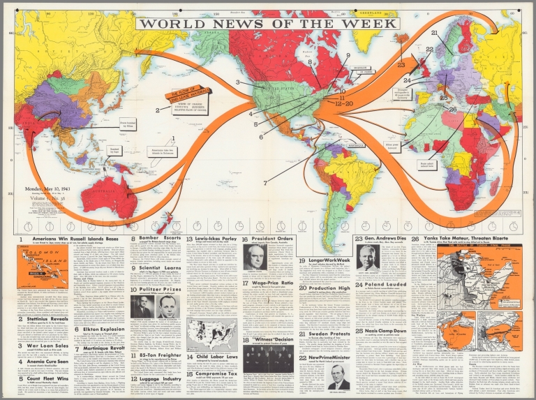
Lithographed world map, in color. Shows political boundaries and military events of World War II, from April 20 to May 6, 1943. Relief illustrated with hachures. Includes international flow-lines for Lend-lease materials. Descriptive text throughout, e.g.: Strongest earthquake in 40 years rocks Germany. Map indexed according to historical notes beneath map. Features photographs, illustrations, and international time zones. With three inset maps: Solomon Island -- (U. S. coal areas) -- The battle of Tunisia : Final phase. Map is 56 x 115 cm, on sheet 89 x 120 cm, folded to 31 x 23 cm.
World Area:
World
Country:
United States
Country:
Tunisia
Region:
Solomon Islands
Event:
World War II
Subject:
Pictorial map
Subject:
Military
Subject:
Historical
Subject:
Data Visualization
Full Title:
World News of the Week : Monday, May 10, 1943. Covering period Apr. 30 to May 6. Volume 5, No. 36. Published and copyrighted (weekly), 1943, by News Map of the Week, Inc., 1512 Orleans Street, Chicago, Illinois. Published in two sections : Section one. Lithographed in U. S. A.
List No:
14132.000
Publication Author:
News Map of the Week, Inc.
Pub Date:
1943
Pub Title:
World News of the Week : Monday, May 10, 1943. Covering period Apr. 30 to May 6. Volume 5, No. 36. Published and copyrighted (weekly), 1943, by News Map of the Week, Inc., 1512 Orleans Street, Chicago, Illinois. Published in two sections : Section one. Lithographed in U. S. A.
Pub List No:
14132.000
Pub Type:
Separate Map
Pub Height cm:
89
Pub Width cm:
120
Image No:
14132000.jp2
Authors:
News Map of the Week, Inc.