COLLECTION NAME:
David Rumsey Historical Map Collection
Record
Author:
Campbell, A. H. (Albert H.)
Author:
Ives, J.C.
Author:
Whipple, A.W.
Date:
1861
Short Title:
Profile Ft. Smith, Ark.-Martinez, Calif.
Publisher:
A.O.P. Nicholson I-XI
Publisher Location:
Washington
Publisher:
T. Ford XII.
Type:
Book Map
Obj Height cm:
61
Obj Width cm:
94
Scale 1:
950,400
Note:
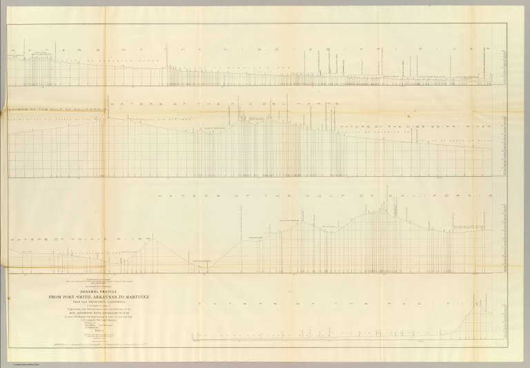
Uncolored profiles. Horizontal scale 1:19,008.
Reference:
WC 262.
State/Province:
U.S. West
Subject:
Railroad
Full Title:
General profile from Fort Smith, Arkansas, to Martinez, near San Francisco, California, to accompany the maps of Explorations and Surveys made under the direction of Hon. Jefferson Davis, Secretary of War by Lieut. A.W. Whipple, Topl. engrs., assisted by Lieut. J.C. Ives, Topl. Engr., A.H. Campbell, civil engr. & surveyor, Wm. White, Jr., N.H. Hilton, J.P. Sherburne, asst. surveyors. 1853-4. Route near the 35th Parallel. (1861)
List No:
0693.039
Series No:
47
Engraver or Printer:
Hutton, N.H.
Engraver or Printer:
Sherburne, J.P.
Engraver or Printer:
White, William Jr.
Publication Author:
Pacific Railroad Survey
Publication Author:
Warren, Gouverneur Kemble, 1830-1882
Pub Date:
1861
Pub Title:
Reports of Explorations and Surveys, to Ascertain the Most Practicable and Economical Route for a Railroad From the Mississippi River to the Pacific Ocean. Made Under the Direction of the Secretary of War, In 1853-56, According to Acts of Congress of March 3, 1853, May 31, 1854, and August 5, 1854. Volume XI. Washington: George W. Bowman, Printer. 1861. 36th Congress, 2d Session, Senate, Ex. Doc.
Pub Reference:
WC 262.
Pub Note:
This Quarto issue of the report is the House issue, except for volume XI which is the Senate issue. W. Heckrotte has an unusual copy of the Warren U.S. map found in this report. It is dissected on linen and is an earlier version of the map published with the Quarto report. It has 40 authorities vs. 42 in the quarto issue map, shorter note to left of authorities, lots of plate differences, especially: nothing in Owyhee area, differences in N.M., Calif., etc. Looks like someone asked for the map before it was finished -see the Lack of ocean lines in the top half south of Gray's Harbor. In 13 volumes. Bound in full leather with "Explorations and Surveys for a Railroad to the Pacific Ocean" and the volume number on the spine in gold.
Pub List No:
0693.000
Pub Type:
Exploration Book
Pub Maps:
24
Pub Height cm:
31
Pub Width cm:
25
Image No:
0693039
Authors:
Campbell, A. H. (Albert H.); Ives, J.C.; Whipple, A.W.
Collection:
Rumsey Collection