COLLECTION NAME:
David Rumsey Historical Map Collection
Record
Author:
Anonymous
Date:
1745
Short Title:
Plan of Cape Breton.
Publisher:
London Magazine
Publisher Location:
London
Type:
Separate Map
Obj Height cm:
10
Obj Width cm:
16
State/Province:
Nova Scotia
City:
Louisbourg (N.S.)
Region:
Cape Breton Island
Full Title:
Plan of Cape Breton.
List No:
10666.000
Publication Author:
Anonymous
Pub Date:
1745
Pub Title:
Plan of Cape Breton.
Pub Note:
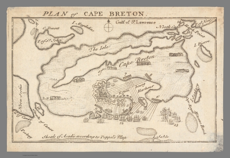
"map from the August 1745 number of The London Magazine, illustrating an essay titled “Reflections occasion’d by the late Conquest of CAPE BRETON”. The plan depicts the fortress, harbor and the surrounding country, all wildly out of scale relative to the rest of Cape Breton Island. French fortifications, “English” (i.e., American) siege works, the British fleet are shown, with 17 numbered locations identified by a key on the following page of the magazine (not included here). They are as follows: “1 Royal Fort of 36 forty-two Pounders. 2 The Town. 3 Light-house 4 Battery thrown down into the Sea. 5 Battery that play’d on our People. 6 Battery to guard the Harbour. 7 Batter fronting the Passage. 8 English Battery, that play’d on the Town. 9 English Battery, that beat down the Drawbridge. 10 English weighing up the Cannon Battery. 11 The Enemy coming to hinder them. 12 Commodore Warren’s Ships bombarding the Fort. 13 Ships lying to guard the Harbour from Vessels going in and coming out. 14 Isle St. Paul. 15. Chibout. 16 Isle de Maurepa. 17 Beach-head.”" (Boston Rare Maps, 2020) Our copy is the same map but not from the same plate so it may have been from another publication at about the same time.
Pub List No:
10666.000
Pub Type:
Separate Map
Pub Height cm:
10
Pub Width cm:
16
Image No:
10666000.jp2
Authors:
Anonymous