COLLECTION NAME:
David Rumsey Historical Map Collection
Record
Author:
Carleton, Osgood
Date:
1801
Short Title:
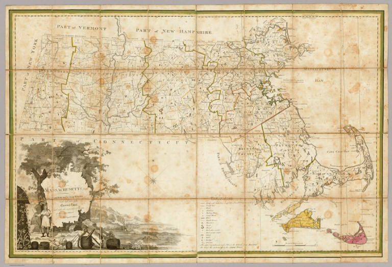
Map Of Massachusetts.
Publisher:
Osgood Carleton
Publisher Location:
Boston
Type:
Case Map
Obj Height cm:
81
Obj Width cm:
119
Scale 1:
253,440
Note:
Engraved by Joseph Callender and Samuel Hill. Second map of Massachusetts by Carleton (1st was 1798), reengraved from the plates of the first issue, and the first official state map (the first edition was rejected by the legislature). With outline and full color. Map is dissected into 32 sections and mounted on linen. Folds into original black cardboard slip case 21x16 with a red leather label on the spine reading "Map Of Mass." in gilt.
Reference:
Phillips Maps p400; Ristow p92.
State/Province:
Massachusetts
Full Title:
Map Of Massachusetts Proper Compiled from Actual Surveys, made by Order of the General Court, and under the inspection of Agents of their appointment, By Osgood Carleton. Engraved by Joseph Callender and Samuel Hill, Boston, 1801. Vignette Drawn by G. Graham.
List No:
2258.001
Series No:
2
Engraver or Printer:
Callender, Joseph
Engraver or Printer:
Graham, G.
Engraver or Printer:
Hill, Samuel, 1766?-1804
Publication Author:
Carleton, Osgood
Pub Date:
1801
Pub Title:
Map Of Massachusetts Proper Compiled from Actual Surveys, made by Order of the General Court, and under the inspection of Agents of their appointment, By Osgood Carleton. Engraved by Joseph Callender and Samuel Hill, Boston, 1801. Vignette Drawn by G. Graham.
Pub Reference:
Phillips Maps p400; Ristow p92.
Pub Note:
See note field above.
Pub List No:
2258.000
Pub Type:
Case Map
Pub Maps:
1
Pub Height cm:
21
Pub Width cm:
16
Image No:
2258001
Authors:
Carleton, Osgood
Collection:
Rumsey Collection
Map Of Massachusetts.