COLLECTION NAME:
David Rumsey Historical Map Collection
Record
Author:
Generalstab Des Heeres, Abteilung Für Kreigskarten Und Vermessungswesen (General Staff of the Army, Department for District Maps and Surveying
Date:
1942
Short Title:
Stadtplan von Stalingrad.
Publisher:
Generalstab des Heeres
Publisher Location:
Berlin
Type:
Separate Map
Obj Height cm:
84
Obj Width cm:
67
Scale 1:
20,000
City:
Volgograd (Russia)
Event:
World War II
Subject:
Military
Full Title:
Stadtplan von Stalingrad.
List No:
10842.001
Series No:
1
Publication Author:
Generalstab Des Heeres, Abteilung Für Kreigskarten Und Vermessungswesen (General Staff of the Army, Department for District Maps and Surveying
Pub Date:
1942
Pub Title:
Stadtplan von Stalingrad.(with) Mil-Geo-Karte of Stalingrad
Pub Reference:
Cf. (re: related blueprint map:) Library of Congress: OCLC: 53254354.
Pub Note:
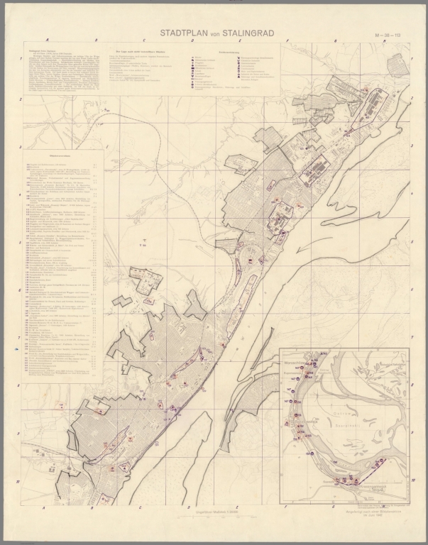
"Extremely rare and historically important – the definitive classified map used by Wehrmacht commanders at the Battle of Stalingrad (August 23, 1942 – February 2, 1943), the turning point of World War II; a large format, extremely detailed map of Stalingrad city noting all major buildings and strategic targets predicated upon recent aerial reconnaissance, the verso featuring a regional map with extensive intelligence notes; an early edition issued on the eve of the epic showdown which destroyed the city, resulting in 2 million casualties and hailing the beginning of the end of the Nazis’ ambitions in the East. Nazi Germany invaded the Soviet Union in June 1941 in what was known as Operation Barbarossa, a ‘Blitzkreig’ (Lightening Warfare) campaign that sought to conquer all of the country west of the ‘A-A Line’ (the imagined meridian running from Archangel down the Astrakhan). The Germans were highly confident as the same techniques of rapid, mechanized warfare had practically mowed down France the year before. However, the Wehrmacht severely underestimated the extraordinary bravery and self-sacrifice of the Red Army troops and the severity of the Russian climate. By the end of the 1941 campaign season, while Germany had conquered much of Ukraine and a good part of European Russia, it fell well short of its goal, failing to take Moscow or reach the Caucuses. Both sides were incredibly exhausted, having lost astounding amounts of men and equipment. During the 1942 campaign season, the Nazis pursued Case Blue, a high-risk/high-reward strategy that aimed to seize the Baku Oil Fields, the realization of which would abundantly fuel the German war machine, while dealing a knockout blow to Soviets. However, the amount of blood and treasure required promised to strain Germany to its extreme limits, risking not only its ambitions in the East, but also its dominant position in Western Europe. In the summer 1942, Case Blue saw good early progress, with the Germans crossing the Don River and gradually taking over the northwestern Caucuses. However, to the back of these gains was a major obstacle that had to be overcome. Stalingrad (today Volgograd) was a colossally important industrial centre of almost half a million residents along the southwestern bend of the mighty Volga River. The seizure of the city was considered absolutely necessary for the Nazis to progress towards Astrakhan and Baku. In anticipation of a German attack upon the city, Joseph Stalin ordered its vast stores of food and provisions to be transported east, while cruelly forcing 400,000 of its civilian residents to remain in Stalingrad as fodder to aid the defense, while 187,000 Red Army troops were left to hold the city. The Wehrmacht, spearheaded by the 6th Army and the 4th Panzer Army (and supported by corps of their Romanian, Hungarian and Croatian allies), attacked Stalingrad on August 23, 1942 with a force of 270,000 troops backed by massive air support. During ferocious combat and intense bombing which destroyed most of the city, the Germans managed to push the Soviets into a narrow corridor along the western bank of the Volga yet failed to evict them from the city. Recognizing the importance of the showdown, each side moved in forces that eventually numbered over 1 million each. The ensuing street by street fighting was inarguably one of the most horrendous military experiences of all time, while the suffering of the civilian population was indescribable, so many were killed, while others were enslaved by the Germans. A brutal stalemate continued until the Soviets launched Operation Uranus, a massive push to expel or destroy the German forces in Stalingrad. The offensive was launched on November 12, 1942 and concentrated upon hitting the Axis flanks, which were largely manned by poorly equipped Romanian troops. This succeeded brilliantly, as the Soviets surged forward to encircle 265,000 Axis troops in the city centre. Winter set in, bringing bone-chilling temperatures, with the entrapped Germans running out of food, fuel, ammunition and warm clothing. Hitler refused to allow the encircled troops to attempt a breakout, as he insisted that the city must be held at all costs. Efforts by the German army and Luftwaffe to open a relief corridor failed. After enduring unimaginably horrendous conditions, what remained of the entrapped German forces surrendered to the Soviets on February 2, 1943. In the end, the Axis side had lost over 850,000 men, while the Soviets suffered 1.15 million casualties. The Battle of Stalingrad proved to be the turning point of World War II. The defeat shattered the illusion that Germany was destined to win the war, and it depleted their forces so dramatically that the Wehrmacht never recovered. From that point onwards, the Germans were always on the defensive, with the Red Army constantly pushing them westwards. The Allied invasion of Italy, commencing in August 1943, saw the Third Reich fighting on two fronts, and its fate was sealed upon the Allied landings in France in June 1944. The last year of the war was merely the Third Reich’s attempt to delay the inevitable, for history’s most evil empire fell in May 1945. The present work was by far and away the best and most important map of Stalingrad available to the German high command. It was separately issued in Berlin by the Department of War Mapping and Surveying of the General Staff of the German Army in early August 1942, only days before the Wehrmacht attacked Stalingrad (the verso of the map notes that it was updated to August 1, 1942). The present example is an early, and perhaps the first, edition of the map (such WWII German maps, despite their obvious importance, are not well researched), with revised editions being issued during the following months. The map would have been considered highly classified due to the vast amount of militarily sensitive information it contains, and its circulation would have been strictly limited to senior Axis field commanders and military planners. The work is printed double-sided, with a large-scale bi-chrome map of the city of Stalingrad proper on the recto, while the verso features a regional map. Both maps are jam-packed with vast amounts of valuable recent intelligence, backed up the be extensive marginal text. The map on the front side, the Stadtplan von Stalingrad, depicts the entire city in amazing detail, to scale of 1:20,000. A note in the lower right reads: ‘Angefertigt nach einer Bildplanskizze im Juni 1942’, revealing that the map was based on a ‘bildskizze’ (picture sketch) composed of aerial photographs taken by the Luftwaffe in June 1942 (the German air force made frequent risky reconnaissance flights deep into Soviet-held territory in advance of anticipated German land operations). The main map shows that the city of Stalingrad occupied a long, narrow strip along the west bank of the mighty Volga. Every street and block are outlined, with all buildings and facilities of any import are depicted, notably including the immense number of large factories, warehouses and related infrastructure, which are coloured in purple to distinguish them from the otherwise grisaille urban plan. The inset in the lower right corner extends the map’s coverage to embrace the southern extremity of the city that hooked around the bend of the Volga. The ‘Zeichenerklärung’ (Explanation of Symbols), in the upper left, identifies bridges, military buildings, hospitals, public buildings, schools, warehouses, fuel storage depots, trains stations, utility company facilities, heavy metal factories, important machine parts and transport factories, minor metalworks, chemical plants, tire factories, leather factories, textile firms, wood and paper plants, stone and gravel works and food processing plants. The ‘Objectverziechnis’ (Object Directory), on the left side, labels 65 key industrial sites (numbered 101 to 165), often by name and providing the number of workers employed by each. These facilities would be the main targets for the German Army and Luftwaffe during the upcoming battle, as destroying the factories would severely harm the Soviet Union’s military-industrial output, while salvaging any useful equipment or products could aid the German war effort. In the upper centre the ‘Lage nach nicht feststellbare Objekte’, features a list of places for which their exact locations could not be determined. The descriptive paragraph in the upper right corner notes that Stalingrad had population of 445,470 (1939), of which 1,580 were ethnic Germans (being ‘Volga Germans’, descendants of those who moved to the area in the 18th century), whom the Nazis hoped to use as local allies and intelligence assets, while going on to give descriptions of some of the city’s key attributes. On the map, the riverbanks have been contemporarily outlined in dark grey crayon and pen, while many of the key industrial targets are highlighted in orange crayon, supposedly added by German officers to lend contrast to the map in the field. The verso of the work features the Mil-Geo-Karte of Stalingrad, a regional map taken from Sheet D49 of the German General Staff’s map, Osteuropa 1:300,000; the present view is described as being updated to August 1, 1942. The map embraces the area of the great bend of the Volga, with the city of Stalingrad on the left side, and the river flowing in the direction of Astrakhan and the Caspian Sea. All roads and the railway along the eastern bank of the Volga (which is noted as still being under construction), running from Stalingrad towards Astrakhan, are delineated. The ‘Zeichenerklärung’ on the right margin, identifies numerous features, while the ‘Objectverziechnis’ (Object Directory) give the coordinates for ten important industrial sites located in the countryside beyond Stalingrad. Symbols note the locations of the ‘Deutsche Siedlungen’ (Volga German Settlements), while the extensive text along the left side grants detailed descriptions of the region’s topography, geology, climate (midwinter temperatures averaged -9.9°C!), water systems (the level of the Volga), transport routes and the economy. The map, in any of its editions, is exceedingly rare. Examples would have been issued in very small print runs for the classified use of only senior Axis commanders. Moreover, the map would have had a very low survival rare, especially considering its use in the brutal conditions of the Stalingrad battle theatre. We cannot trace any other examples of the present early (August 1942) edition of the map, either in institutional collections or sales records. However, we have been able to find internet references to a couple of later, modified editions, held in unspecified Russian libraries. While there are probably a handful of other examples of various editions in German institutions, we have not been able to locate any references (many German World War II archives are not well catalogued). Also, of note, the Library of Congress holds a map likewise entitled Stadtplan von Stalingrad, described as a blueprint, that seems to be related to the present work." (Alexander Johnson and Dasa Pahor, 2021)
Pub List No:
10842.000
Pub Type:
Separate Map
Pub Height cm:
84
Pub Width cm:
67
Image No:
10842001.jp2
Authors:
Generalstab Des Heeres, Abteilung Für Kreigskarten Und Vermessungswesen (General Staff of the Army, Department for District Maps and Surveying