COLLECTION NAME:
David Rumsey Historical Map Collection
Record
Author:
Bache, A. D.
Author:
Hassler, F. R.
Date:
1848
Short Title:
Delaware Bay, River 3.
Publisher:
U.S.
Publisher Location:
Washington
Type:
Atlas Map
Type:
Chart Map
Obj Height cm:
66
Obj Width cm:
90
Scale 1:
80,000
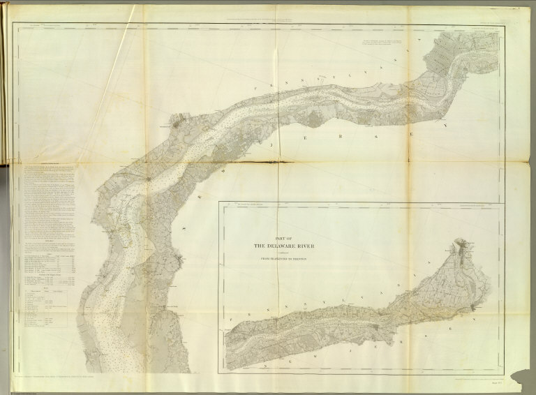
Note:
Engraved nautical chart. North sheet (3 of 3). Inset: Part of the Delaware river continued from Frankford to Trenton. Relief shown by hachures; depths by soundings. Includes descriptive notes on the survey, sailing directions, tides and currents. Oriented with north toward upper left. Prime meridians: Greenwich and New York. In upper margin "Presented under authority of an act of Congress of the United States of June 3d 1844 by direction of the Treasury Department, A.D. Bache Superintendent Coast Survey."
Reference:
Guthorn, p. 77.
State/Province:
Delaware
State/Province:
New Jersey
State/Province:
Pennsylvania
Region:
Delaware River (N.Y.-Del. and N.J.)
Full Title:
(Map of Delaware Bay and River). Sheet no. 3. (Founded upon a trigonometrical survey under the direction of F.R. Hassler and A.D. Bache, Superintendents of the Survey of the Coast of the United States. Triangulation by F.R. Hassler, assts. J. Ferguson, E. Blunt, C.M. Eakin, F.H. Gerdes, J.J.S. Hassler & J.E. Johnstone, Capt. Topl. Engrs. Topography by assistants W.M. Boyce, F.H. Gerdes, J.J.S. Hassler, H.L. Whiting, G.D. Wise & B.F. Sands, U.S.N. Hydrography by the party under the command of G.S. Blake, Lieutenant U.S. Navy. Soundings outside the capes under the direction of T.R. Gedney and G.M. Bache, Lieutenants U.S. Navy. Published in 1848. A.D. Bache, Superintendent). Final reduction for engraving of topography by W.M.C. Fairfax, asstist. & of hydrography by Lt. J.B. Dale, U.S.N. & J.B. Gluck, assistant. Engraved by F. Dankworth, assisted by O.A. Lawson. Lettering by F. Dankworth & J. Knight. Electrotype copy no. 4 by G. Mathiot, U.S.C.S.
List No:
2470.024
Series No:
28
Engraver or Printer:
Blake, G. S.
Engraver or Printer:
Blunt, Edmund M. (Edmund March), 1770-1862
Engraver or Printer:
Boyce, W. M.
Engraver or Printer:
Eakin, C. M.
Engraver or Printer:
Ferguson, James
Engraver or Printer:
Gedney, Thomas R.
Engraver or Printer:
Gerdes, Ferd. H.
Engraver or Printer:
Hassler, J. J. S.
Engraver or Printer:
Johnstone, J. E.
Engraver or Printer:
Sands, B. F.
Engraver or Printer:
Whiting, H.L.
Engraver or Printer:
Wise, G. D.
Publication Author:
Bache, A. D.
Publication Author:
United States Coast Survey
Pub Date:
1854
Pub Title:
(Covers to) Maps and charts of the United States Coast Survey. A.D. Bache, Superintendent. To July, 1854.
Pub Reference:
P1269; U.S. Atlases L 167.
Pub Note:
See note field above.
Pub List No:
2470.000
Pub Type:
Chart Atlas
Pub Maps:
57
Pub Height cm:
31
Pub Width cm:
28
Image No:
2470024
Authors:
Bache, A. D.; Hassler, F. R.
Collection:
Rumsey Collection