COLLECTION NAME:
David Rumsey Historical Map Collection
Record
Author:
Geological Survey (U.S.)
Author:
U.S. Census Bureau
Author:
United States. Department of Agriculture. Statistical Reporting Service
Date:
1964
Short Title:
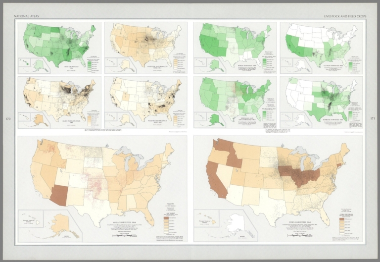
Field crops sold : 1964 ... Barley harvested : 1964 ...
Publisher:
United States Department of the Interior Geological Survey
Publisher Location:
Washington D.C.
Type:
Atlas Map
Obj Height cm:
42
Obj Width cm:
31
Scale 1:
17,000,000
Note:
Ten economic maps representing the United States, featuring crops sold and harvested - such as wheat, barley, cotton and corn - as of 1964. Maps also show political boundaries, bodies of water, coastlines and islands. Maps include legends, as well as bar scales and scale statements (scales differ). Presented with Albers Equal Area Projection. With two inset maps within each map: Principal islands of Hawaii -- Alaska. Colored lithograph. Together, maps are 42 x 31 cm, on sheet 49 x 35 cm. Maps appear in Special subject maps section, subsection Economic : Agriculture.
Country:
United States
Subject:
Commerce; Economics
Subject:
Land Use
Subject:
Agriculture
Full Title:
Field crops sold : 1964 -- Livestock and products sold : 1964 -- Dairy products sold : 1964 -- Poultry and products sold : 1964 / the four maps above compiled from U. S. Bureau of the Census, Census of agriculture: 1964, v. I, Washington, U. S. Govt. Print Off., 1967, county table 6, and State table 17 -- Wheat harvested : 1964 / compiled from U. S. Bureau of the Census, Census of agriculture: 1964, v. I, county table 13, and v. II, chap. 4, table 16, Washington, U. S. Govt. Print Off., 1967; Statistical Reporting Service, Field crops, Stat. Bull. 384, Washington U. S. Dept. of Agriculture, 1966, table 1. (with) Barley harvested : 1964 / compiled by Census of agriculture: 1964, v. I, county table 13, v. II, chap. 4, table 25; Field crops, Stat. Bull. 384, tables 11 & 46 -- Cotton harvested : 1964 / compiled by Census of agriculture: 1964, v. I, county table 13; Field crops, Stat. Bull. 384, table 45 -- Sorghums and oats harvested : 1964 / compiled by Census of agriculture: 1964, v. I, county table 13, v. II, chap. 4, table 24; Field crops, Stat. Bull. 384, tables 10 & 46 -- Soybeans harvested : 1964 / compiled by Census of agriculture: 1964, v. I, county table 13, v. II, chap. 4, table 45; Field crops, Stat. Bull. 384, table 23 -- Corn harvested : 1964 / compiled by Census of agriculture: 1964, v. I, county table 13, and v. II, chap. 4, table 12, Washington, U. S. Govt. Print Off., 1967; Statistical Reporting Service, Field crops, Stat. Bull. 384, Washington U. S. Dept. of Agriculture, 1966, table 9.
List No:
14359.125
Page No:
170-171
Series No:
125
Publication Author:
Geological Survey (U.S.)
Publication Author:
Pecora, William T.
Publication Author:
Gerlach, Arch C.
Publication Author:
Overstreet, William B.
Pub Date:
1970
Pub Title:
The national atlas of the United States of America. United States Department of the Interior Geological Survey, Washington, D. C. 1970.
Pub Note:
The national atlas of the United States of America, by the United States Geological Survey; published in Washington D. C., 1970. Bound in navy blue board, with title printed in silver on both front cover and spine. Accompanied by envelope with six overlay sheets, tucked between final page and back cover of volume. Collation: [i-vi], vii-xiii, [1], 2-417, A1, A2, B1, B2, C, D. Atlas contains 770 maps and 18 charts. Includes a dedication, foreward, list of contributors, introduction, table of contents and index to map subjects. Topic covered: physical geography, history, economics, culture, administrative boundaries and cartography. In addition, atlas also provides maps of the world, as related to the United States. Maps show political boundaries, cities, railways, roads, topography, bodies of water, glaciers, drainage, coastlines, islands, water depths and time zones. Topical maps feature other details, such as history, geology, climate, agriculture, population, racial demographics (including indigenous peoples), religion, language and transportation. Some maps use data visualization to further illustrate geographical information, with charts overlaid upon the landscape. "Adapted from "About The National Atlas of the United States of America," by the U.S. Geological Survey: The National Atlas of the United States of America was published in 1970. It was designed to be of practical use to decision makers in government and business, and for planners and research scholars as well as others needing to visualize country-wide distributional patterns and relationships between environmental phenomena and human activities. The National Atlas represents the principal characteristics of the country in 1970, including its physical features, historical evolution, economic activities, sociocultural conditions, administrative subdivisions, and place in world affairs. Various federal agencies, professional organizations, and commercial firms had advocated producing a National Atlas of the United States of America, but the magnitude of the task and the scope of the research required deterred those who would begin it. Late in 1954, the National Academy of Sciences-National Research Council established a Committee on the National Atlas of the United States, with representatives from several federal mapmaking agencies. The committee's primary responsibilities were to coordinate all federal agencies that would be involved in producing the atlas and to ensure uniform quality in its cartography. This proved to be a nearly impossible task, and consequently in 1961 the committee terminated itself. In so doing it recommended that the atlas be completed by one federal agency, preferably the Geological Survey in the U.S. Department of the Interior. In March of 1961, the Secretary of the Interior accepted the challenge. Congress appropriated funds to begin work on the National Atlas in 1963, and on reimbursable loan the Library of Congress made available the chief of its Geography and Map Division, Dr. Arch C. Gerlach, to serve as editor. Eighty-four agencies and bureaus appointed liaison officers to the National Atlas Project, base maps were prepared at four scales, and an advisory group of eminent cartographers and geographers collaborated to formulate fundamental design principles and specifications. The first part of the National Atlas is devoted to general reference maps that contain most of the forty-one thousand place names recorded in the index. These maps were included for the convenience of readers wanting basic locational information. In the thematic section of the National Atlas, separate subdivisions deal with the country's physical, historical, economic, and socio-cultural characteristics. The maps in this portion of the atlas represent the relationships between human beings and their environment while offering scientific bases for analyzing the nation's economic development in 1970. The National Atlas proved to be the last paper atlas of this magnitude produced by the federal government."
Pub List No:
14359.000
Pub Type:
National Atlas
Pub Maps:
770
Pub Height cm:
50
Pub Width cm:
37
Image No:
14359125.jp2
Authors:
Geological Survey (U.S.); U.S. Census Bureau; United States. Department of Agriculture. Statistical Reporting Service