COLLECTION NAME:
David Rumsey Historical Map Collection
Record
Author:
Pantoflíček, Jaroslav
Author:
Česká akademie věd a umění.
Date:
1932
Short Title:
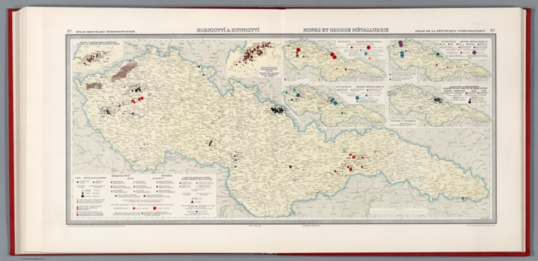
Hornictvi a hutnictvi = Mines et gross métallurgie
Publisher:
Nákladem akc. spol. Orbis
Publisher Location:
V Praze
Type:
Atlas Map
Obj Height cm:
34
Obj Width cm:
76
Scale 1:
1,250,000
Note:
Map of mining and heavy metal industry of Czech Republic with 6 insets on 2 sheets. Showing location of mines and mining productions. Includes color coded reference.
Country:
Czech Republic
Subject:
Data Visualization
Subject:
Mining
Subject:
Industry
Full Title:
Hornictvi a hutnictvi = Mines et gross métallurgie. Karel Malik. Data z roku 1929. 37. Atlas Republiky Československé = Atlas de la Republique Tchecoslovaque. Vydala Ceska akademie ved a umeni -1932- Editeur Nakladatelstvi Orbis, Praha : Tiskne Vojenskyì zeměpisnyì uìstav.
List No:
13678.043
Page No:
37
Series No:
43
Engraver or Printer:
Láska, Václav Jan,
Engraver or Printer:
Malik, Karel
Publication Author:
Pantoflíček, Jaroslav
Publication Author:
Česká akademie věd a umění.
Pub Date:
1935
Pub Title:
Atlas Republiky Československé = Atlas de la Republique Tchecoslovaque. Vydala Ceska akademie ved a umeni za podpory ministerstva zahranicnich veci republiky Ceskoslovenské. Nakladem akc. spol. Orbis v. Praze XII. 1935.
Pub Note:
The first national atlas of Czechoslovakia and is also considered as one of the first modern national atlases. It was published in between the WWI and WW2 - the golden era of Czechoslovakian nation called "The First Republic". After the country gained independence from Austria-Hungarian monarchy it became a nationwide interest to publish a geographic and statistical atlas objectively and precisely presenting the nation's current state of society and economy. Published by the Czech Academy of Sciences and Arts; with the support of the Ministry of Foreign Affairs of the Czechoslovak Republic; The top editorial staff was led by Prof. Dr. Ing. Jaroslav Pantoflíček; The maps were technically executed by the Military Geographical Institute in Prague; The graphic design by the director Em. Purghart; Text in French and Czech, was printed by the Orbis book printing house in Prague; Bindings by A. Škoda firm; Editorial work began in 1925, printing ended in 1935. Includes one page with 4 different coat of arms in stunning colors, 55 large double-page of thematic maps from geography, geology, climate, society, culture, industry, agriculture, transport, economy, national and international trade. Includes 37 pages of text at the end of atlas, with title page: Atlas Republiky ceskoslovenske; textovy doprovod k mapam redigoval Vaclav Laska. Bound in hardcover red cloth with Czech Republic Code of Arms on front, with cover title “Atlas RCS”.
Pub List No:
13678.000
Pub Type:
National Atlas
Pub Maps:
55
Pub Height cm:
44
Pub Width cm:
45
Image No:
13678043.jp2
Authors:
Pantoflíček, Jaroslav; Česká akademie věd a umění.