COLLECTION NAME:
David Rumsey Historical Map Collection
Record
Author:
Ulloa, Antonio de, 1716-1795
Author:
Juan, Jorge, 1713-1773
Date:
1748
Short Title:
Plano de la Ciudd. de S. Franco. del Quito ...
Publisher:
Antonio Marin
Publisher Location:
Madrid
Type:
Atlas Map
Obj Height cm:
31
Obj Width cm:
49
Note:
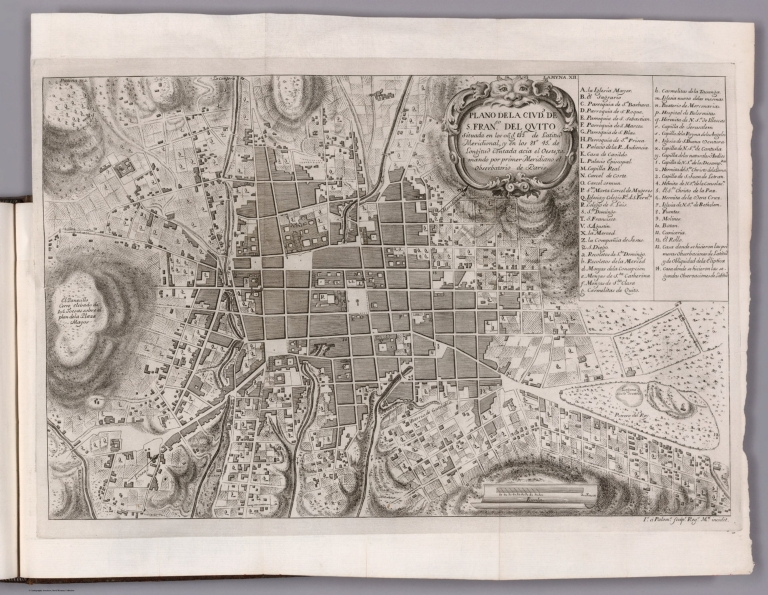
Map featuring the city of Quito, Ecuador. Shows city blocks, streets, topography, vegetation and drainage. Relief shown pictorially. Includes explanatory notes, as well as a bar scale and compass rose with north oriented toward upper right side of sheet Indexed to indicate place names. With decorative cartouche. Black and white engraving. Map is 31 x 49 cm, on fold-out sheet 40 x 53 cm. Appears in the first volume of Relacion historica del viage hecho de orden de S. Mag. a la America Meridional.
City:
Quito (Ecuador)
Subject:
Exploration
Full Title:
Plano de la Ciudd. de S. Franco. del Quito ... Is. á Palomo sculpr. Regs. Mri. incidit.
List No:
14378.033
Page No:
XII
Series No:
33
Engraver or Printer:
Palomo
Publication Author:
Ulloa, Antonio de, 1716-1795
Publication Author:
Juan, Jorge, 1713-1773
Pub Date:
1748
Pub Title:
Relacion historica del viage a la America Meridional hecho de orden de S. Mag. para medir algunos grados de meridiano terrestre, y venir por ellos en conocimiento de la verdadera Figura, y Magnitud de la Tierra, con otras varias Observaciones Astronomicas, y Phisicas : Por Don Jorge Juan, Comendador de Aliaga, en el Orden de San Juan, Socio correspondiente de la Real Academica de las Ciencias de Paris, y Don Antonio de Ulloa, de la Real Sociedad de Londres : ambos Capitanes de Fragata de la Real Armada. Impressa de orden del Rey Nuestro Señor en Madrid por Antonio Marin, ano de M. DCC. XLVIII.
Pub Note:
Relacion historica del viage hecho de orden de S. Mag. a la America Meridional, by Antonio de Ulloa and Jorge Juan; published in Madrid by Antonio Marin, 1748. Title translates (loosely) to: Historical relation of the trip to South America made by order of S. Mag. to measure degrees of the terrestrial meridian, and to come by them in knowledge of the true figure and magnitude of the Earth, with several other astronomical and physical observations. Four volumes, bound in leather. Spines have raised bands and gilt floral ornamentation, as well as leather labels with gilt titles. Each volume has marbled end papers with the same bookplate on verso of front cover. Collation: V. I: [1-24], [1], 2-404 pages, 1-5, VI-XIII leaves of plates; V. II: 4, 405-682 pages, XIV-XXI leaves of plates; V. III: [1-12], [1], 2-379, pages, I-X leaves of plates; V. IV: [1-4], [381], 382-603, i-cxcv pages, XI-XII, [XIII] leaves of plates. Each volume includes a half title page and title page with an engraved illustration. Prologue in first volume; table of contents and errata in first and third volumes; indexes in second and fourth volumes; frontispiece in third volume; text throughout. Together, the four volumes contain 12 maps, as well as numerous profile views, illustrations and portraits. Maps show cities, fortifications, roads, bridges, topography, vegetation, bodies of water, drainage, coastlines, islands, shoals, depths, ports and anchorage. Some maps formatted as bird's-eye-views. Black and white engravings. Full scan of the work is available at The Internet Archive (see Pub Reference). For French single-volume atlas of Quito in the Collection, see Pub List No. 14377.000.
Pub List No:
14378.000
Pub Type:
Regional Atlas
Pub Type:
Exploration Book
Pub Maps:
12
Pub Height cm:
28
Pub Width cm:
22
Image No:
14378033.jp2
Authors:
Ulloa, Antonio de, 1716-1795; Juan, Jorge, 1713-1773