COLLECTION NAME:
David Rumsey Historical Map Collection
Record
Author:
Mitchell, Samuel Augustus
Date:
1836
Short Title:
North Carolina South Carolina and Georgia
Publisher:
S. Augustus Mitchell
Publisher Location:
Philadelphia
Type:
Pocket Map
Obj Height cm:
46
Obj Width cm:
56
Scale 1:
1,774,080
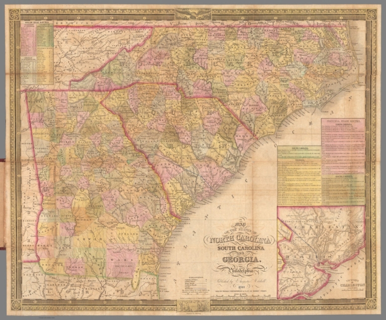
Note:
First issued in Finley's American Atlas 1826, then reissued by Mitchell in 1831, this 1841 edition continues with an inset of Charleston and tables of stage and steamboat routes . Folded into dark brown leather covers 13.5x8 with "Mitchell's Map Of The Carolina's & Georgia" and a decorative border in gilt. Full color. Printed date of 1841 appears to be an erasure of the prior edition 1836 date.
State/Province:
North Carolina
State/Province:
South Carolina
State/Province:
Georgia
Full Title:
Map Of The States Of North Carolina South Carolina and Georgia. Philadelphia: Published by S. Augustus Mitchell. 1841. Sold By Mitchell & Hinman No. 6 North Fifth Street. Entered ... 1835, by S. Augustus Mitchell ... Pennsylvania. Engraved by J.H. Young. (inset) Vicinity Of Charleston.
List No:
15231.002
Series No:
2
Engraver or Printer:
Young, J.H.
Publication Author:
Mitchell, Samuel Augustus
Pub Date:
1836
Pub Title:
Map Of The States Of North Carolina South Carolina and Georgia. Philadelphia: Published by S. Augustus Mitchell. 1841. Sold By Thomas Cowperthwait & Co. 253 Market Street Entered ... 1835, by S. Augustus Mitchell ... Pennsylvania. Engraved by J.H. Young. (inset) Vicinity Of Charleston.
Pub Note:
See note field above.
Pub List No:
15231.000
Pub Type:
Pocket Map
Pub Height cm:
14
Pub Width cm:
8
Image No:
15231002.jp2
Authors:
Mitchell, Samuel Augustus