COLLECTION NAME:
David Rumsey Historical Map Collection
Record
Author:
United States. Naval Oceanographic Office
Author:
United States. Department of the Navy. Bureau of Navigation
Author:
Bartlett, J. R.
Date:
1884
Short Title:
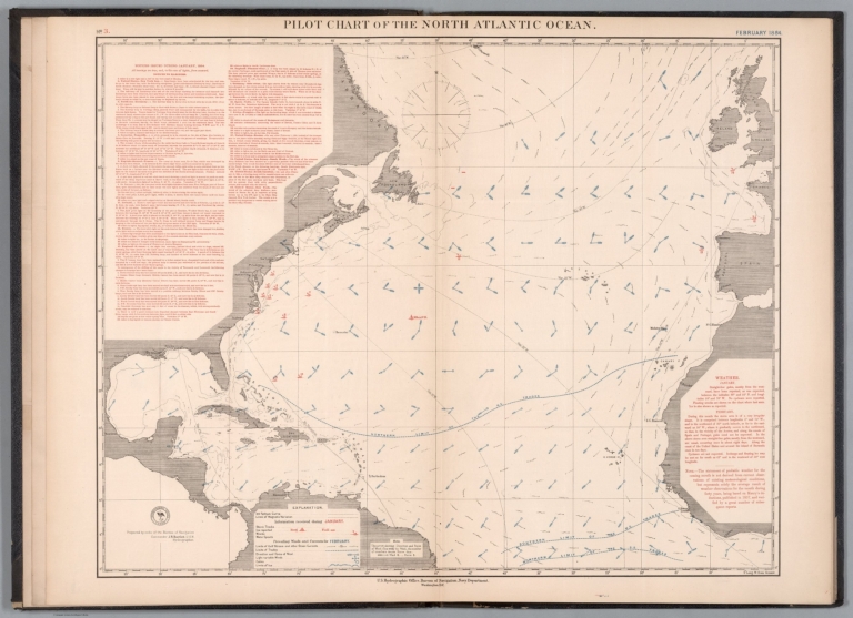
Pilot chart of the North Atlantic Ocean. February 1884.
Publisher:
U.S. Hydrographic Office, Bureau of Navigation, Navy Department
Publisher Location:
Washington, D.C.
Type:
Atlas Map
Obj Height cm:
53
Obj Width cm:
68
Scale 1:
13,000,000
Note:
Nautical chart of the North Atlantic Ocean representing February, 1884. Shows cities, coastlines, islands, sailing routes, ocean currents, storm tracks, wind force and directions, as well as icebergs, ice fields and the limits of ice coverage. Features shipwreck locations with dates of incidents. Includes latitudinal and longitudinal lines, a legend and compass rose with north oriented toward top of sheet. Descriptive text throughout. Black and white engraving, with red and blue infographics. Chart is 53 x 68 cm, on double sheet 60 x 84 cm.
Region:
North Atlantic Ocean
Subject:
Nautical Charts
Subject:
Weather
Subject:
Data Visualization
Full Title:
Pilot chart of the North Atlantic Ocean. February 1884. Prepared by order of the Bureau of Navigation, Commander J. R. Bartlett. U.S.N. Hydrographer. U.S. Hydrographic Office, Bureau of Navigation, Navy Department, Washington, D.C.
List No:
14381.005
Page No:
3
Series No:
5
Publication Author:
United States. Naval Oceanographic Office
Publication Author:
United States. Department of the Navy. Bureau of Navigation
Pub Date:
1886
Pub Title:
Pilot chart : Dec. 1883. 1884-86.
Pub Note:
Pilot chart : Dec. 1883. 1884-86, published in 1886 by the U.S. Hydrographic Office, Bureau of Navigation, Navy Department, Washington, D.C. Originally separate sheets, bound together here in dark brown board. Gilt spine title and seal on front cover: Bibliothek Marinens. Verso to front cover has label - “Farvandsbeskr. B.II.a.l.” and stamp “Marinens Bibliotek, 2den Afdoling, Søkort-Arkivet ... “ Volume comprised of 37 nautical charts of the North Atlantic Ocean. Charts show cities, coastlines, islands, sailing routes, ocean currents, storm tracks, equatorial rains, tropical cyclones and wind, as well as icebergs, ice fields and the limits of ice coverage. Charts feature shipwreck and whale sighting locations with dates of incidents. Data visualization illustrates wind force and directions. Descriptive text accompanies charts. Atlas depicts the ocean activity during each month from December, 1883, to December, 1886. For related works in the collection, see Pub List No. 14388.000 (Pilot chart. 1887-1889), 14389.000 (Pilot chart. 1890-1893), 14890.000 (Pilot chart. 1894-1896) and 14891.000 (Pilot chart of the North Pacific Ocean).
Pub List No:
14381.000
Pub Type:
Chart Atlas
Pub Maps:
37
Pub Height cm:
61
Pub Width cm:
42
Image No:
14381005.jp2
Authors:
United States. Naval Oceanographic Office; United States. Department of the Navy. Bureau of Navigation; Bartlett, J. R.