COLLECTION NAME:
David Rumsey Historical Map Collection
Record
Author:
La Condamine, Charles-Marie de, 1701-1774
Date:
1751
Short Title:
Plan profil et elevation des deux pyramides. (2)
Publisher:
Imprimerie Royale
Publisher Location:
Paris
Type:
Atlas Map
Type:
View
Obj Height cm:
20
Obj Width cm:
30
Note:
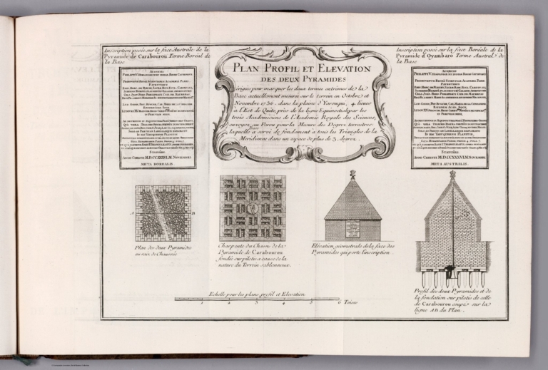
Maps of two pyramids, as well as profile views. Shows architecture, including elevation of buildings. Includes a bar scale and explanatory notes. With decorative cartouche. Black and white engraving. Together, maps and views are 20 x 30 cm, on fold-out sheet 26 x 40 cm. Maps and views appear in second part of volume.
Region:
Quito (Ecuador)
Subject:
Exploration
Full Title:
Plan profil et elevation des deux pyramides. (2)
List No:
14377.014
Series No:
14
Publication Author:
La Condamine, Charles-Marie de, 1701-1774
Pub Date:
1751
Pub Title:
Journal du voyage fait par ordre du roi, a l’équateur, servant d’introduction historique à la mesure des trois premiers degrés du méridien. Par M. de la Condamine. A Paris, de l'Imprimerie Royale. M. DCCLI.
Pub Reference:
Journal ... : Hill (1st ed.), p.169 (note). Sabin 38479; Norman 1250 -- Histoire de Pyramides ... : Palau 129381; Sabin 38478 -- Mesure ... : Sabin 38483; Borba de Moraes I, p.381; Norman 1249.
Pub Note:
Journal du voyage fait par ordre du roi, a l’équateur, by Charles-Marie de La Condamine (1701-1774); published in Paris by Imprimerie Royale, 1751. French exploration of Quito, featuring rare maps of the Quito Pyramids. Volume includes three parts: Condamine’s voyage account, together with a rare work on the pyramids of Quito, Histoire des pyramides de Quito, and the extensive technical paper on the geodetic measurements taken at the equator, Mesure des trois premiers degres du meridien dans l'hemisphere austral. Bound in contemporary French speckled calf. Spine has raised bands and gilt floral ornamentation, as well as leather label with gilt title. With marbled end papers. Three later bookplates on front end paper. Quarto. Collation: [2] xxxvi, 280, xv pages, [7] fold-out leaves of plates; [2], 53 pages, [1] fold-out leaf of plates; [12] 266, x pages, [3] leaves of plates. Each part has its own title page. First part includes a preface and historical introduction; third part has an index. Altogether, volume presents five maps, four views and one illustration. Maps show routes, topography, volcanos, vegetation, drainage, coastline, islands and shoals. Views depict the pyramids, as well as profiles of mountain peaks in the Andes. This work is the first official account of the voyage which Hill described in his earlier bibliography as “the greatest geographical event of the eighteenth century as regards South America.” The measurements in the third part settled a controversy between the Newtonians and the Cartesians over whether the earth was flattened or elongated at the poles. The Newtonian hypothesis was proven correct. The voyage was made at the behest of the French Academy of Science with the objective of measuring one exact degree of the dimensions of the earth. Another expedition was sent to Lapland, and the Spaniards cooperated, chiefly in the persons of Ulloa and Jorge Juan. The expedition took the measurement on the Andean Plateau, near Quito, and the text is rich in data on the area, including maps of Quito and Quito Province, the most detailed illustrations of the area to that time. After the scientific observations were concluded, La Condamine returned with his party to the east coast of South America by descending the Amazon River, becoming the first scientist with any acumen at observation to make that trip. An earlier, unofficial version of the expedition was published in 1745-46. It found wide popularity and was translated into several languages. Usually, the first and third works here are bound together, though rarely does the work on pyramids appear as part of the volume. A rare trio of works relating to the exploration of South America in the mid-18th century. (Historical notes compiled by the William Reese Company, New Haven, Conn.) For Spanish four-volume atlas of Quito in the Collection, see Pub List No. 14378.000.
Pub List No:
14377.000
Pub Type:
Regional Atlas
Pub Type:
Exploration Book
Pub Maps:
8
Pub Height cm:
27
Pub Width cm:
21
Image No:
14377014.jp2
Authors:
La Condamine, Charles-Marie de, 1701-1774