COLLECTION NAME:
David Rumsey Historical Map Collection
Record
Author:
Bunting, Heinrich
Date:
1589
Short Title:
Europe in the Shape of a Queen) Europa Prima Pars Terrae In Forma Virginis . . .
Publisher:
Heinrich Bunting
Publisher Location:
Magdeburg
Type:
Book Map
Obj Height cm:
27
Obj Width cm:
36
Note:
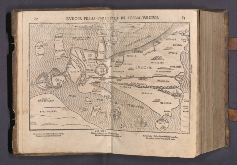
"Protestant theologian Heinrich Bunting's map showing Europe as a queen is one of the most sought after anthropomorphic maps of the 16th Century. The depiction of Europe as a queen began in the 14th Century. Europe was named for princess Europa (Daughter of Phoenicia), who had been carried off and raped by Zeus. The earliest depiction of Europe as a woman is believed to be by the 14th Century Pavian Cleric Opicinus de Canistris for the papal court, then at Avignon. The woman represents the Mother Church, who is being seduced from the true path. In 1537 the Tirolese cartographer Johann Putsch celebrated the Hapsburg rule over Europe by presenting a placid "Europa Regina" wearing Charles V's Spain as a crown and Ferdinand's Austria as a medal at her waist, representing the triumph of the Hapsburgs. The queen's crown (Spain), orb (Sicily), and heart (Bohemia), form a triangle that directs the viewer's eye away from eastern Europe toward the West. The British Isles are a shapeless blob perched near her shoulder. Her skirt is composed of the Baltics and Greece; Turkey and Russia are beneath her feet. Later editions of Europe as a queen were issued by Sebastian Münster, Heinrich Bunting, and Matthias Quad." (Ruderman, 2022)
World Area:
Europe
Full Title:
Europe in the Shape of a Queen) Europa Prima Pars Terrae In Forma Virginis . . .
List No:
15301.005
Series No:
5
Publication Author:
Bunting, Heinrich
Pub Date:
1589
Pub Title:
Itinerarium Sacrae Scripturae. Das ist: Ein Reisebuch, Uber die gantze heilige Schrifft, in zwey Bücher geteilet... Zuvor gemehret mit einem Büchlein De monetis et mensuris... Insonderheit aber mit einer feinen nützlichen Erklerung des Buchs Josua... Mit einer Vorrede des Herrn D. Martini Chemnitii. [with:] Harmonia Evangelistarum...
Pub Reference:
I. VD 16, B 9172; IA 127.711; Tobler 209; van der Heijden, Bünting (in: Cartogr. Helvetica 23), Laor 140-143, Zacharakis 501, Hill, Curiosities 46 and 47 and Tooley, Oddities 2, 3, 88. II. VD 16, B 4667; IA. 127.711.
Pub Note:
"With Bünting's Clover Leaf World, Pegasus as Asia, Europe as a Queen, and Africa. Small quarto (12.5 x 8 inches). Very attractive contemporary blindstamped pigskin over wooden boards, contemporary metal clasps with images of the Crucifixion (leather renewed). 2 books in 1 volume. First book (Itinerarium...): 4 parts in 1. 12 (10 double-page) woodcut maps. Collation: 8 leaves, 250 (recto 252) pages, 4; 3 pages, 110 pages, 4 pages; 34 (recto 35) pages; 3 leaves, 23 (recto 25) pages. Second book (Harmonia...): 3 parts in 1. Collation: 29 pages, 180 pages, 5 leaves; 2 pages, 51 pages, 2; 2 leaves, 487 (recto 490) pages, 7 leaves. Early German edition of Bünting's Itinerarium illustrated with 12 (10 double-page) woodcut maps and plans: 2 world maps (including the famous clover-leaf map), Europe as Virgin, Asia as Pegasus, Africa, 4 maps of the Holy Land, map of the Eastern Mediterranean and plans of Jerusalem and the temple. Bound with the first edition of the Gospel Harmony in the arrangement by Bünting. Henrich Bunting was a Protestant theologian and teacher born in Hanover, in what is now Germany. He attended the University of Wittenberg and graduated in 1569. He then began work as a preacher but caused some controversy with his teachings; he was dismissed from appointments in both Lemgo and Goslar. He is best known today for his book, Itinerarium Sacrae Scripturae (Travel book through Holy Scripture), a travel collection and commentary of the geography of the Bible. The book provided the most complete summary of biblical geography then available and described the Holy Land by following the travels of various notable people from the Old and New Testaments. First published in Madgeburg in 1581, Itinerarium Sacrae Scripturae was a very popular book for the time. Over 60 editions were published between 1581 and 1757. A particularly notable feature of the book were its many woodcut maps, many of them showing unique depictions of geographic features and continents. In addition to the conventional maps, the book also contained three figurative maps; the world depicted using a cloverleaf design (thought to possibly represent the Trinity with Jerusalem in the center), Europe in the form of a crowned and robed woman, and Asia as the winged horse Pegasus." (Ruderman. 2022)
Pub List No:
15301.000
Pub Type:
Geography Book
Pub Type:
Religious Atlas
Pub Height cm:
33
Pub Width cm:
24
Image No:
15301005.jp2
Authors:
Bunting, Heinrich