COLLECTION NAME:
David Rumsey Historical Map Collection
Record
Author:
Cook, James, active 1762-1775
Author:
Jefferys, Thomas
Date:
1775
Short Title:
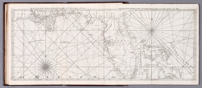
The coast of West Florida and Louisiana ...
Publisher:
Robert Sayer and John Bennett (Firm)
Publisher Location:
London
Type:
Atlas Map
Obj Height cm:
46
Obj Width cm:
121
Scale 1:
1,410,000
Note:
Nautical chart of the coast of West Florida and Louisiana, as well as part of the Gulf of Mexico and the Bahamas, in 1775. Shows cities, topography, vegetation, bodies of water, drainage, coastlines, ports, bays, anchorage, shoals, islands, rocks and depths, given in fathoms. Relief shown pictorially and with hachures. With arrows indicating the direction of ocean currents. Includes rhumb lines, latitudinal and longitudinal lines, as well as compass roses with north oriented toward top of sheet. With descriptive notes throughout. Black and white copper-engraving. Chart is 46 x 121 cm, on fold-out plate 55 x 127 cm. Chart appears in second volume of atlas.
Country:
Bahamas
Region:
Mexico, Gulf of
Region:
Florida, Straits of
Event:
American Revolution
Subject:
Nautical Charts
Full Title:
The coast of West Florida and Louisiana. By Thos. Jeffreys, Geographer to His Majesty. -- The Peninsula and Gulf of Florida or Channel of Bahama Islands. By Thos. Jeffreys, Geographer to His Majesty. London. Printed for Robt. Sayer, Map & Printseller, No. 53 in Fleet Street, as the Act directs ... Feby. 1775.
List No:
14471.045
Page No:
12
Series No:
45
Engraver or Printer:
Jefferys, Thomas, -1771
Publication Author:
Cook, James, active 1762-1775
Pub Date:
1784
Pub Title:
The North-American Pilot for Newfoundland, Labradore, the Gulf and River St. Laurence : Being a collection of sixty accurate charts and plans, drawn from original surveys : taken by James Cook and Michael Lane, Surveyors, and Joseph Gilbert, and other Officers in the King's Service. Published by permission of the Right Hon. the Lords Commissioners of the Admiralty. Chiefly engraved by the Late Mr. Thomas Jeffreys, Geographer to the King. On thirty-six large copper-plates. London: Printed according to Act of Parliament, and sold by R. Sayer and J. Bennett, Map, Chart and Print Sellers, and Globe Manufacturers, No. 53, in Fleet-Street. M.DCC.LXXXIV.
Pub Reference:
Sabin 5557; cf. Phillips 1209 (1777 ed.)
Pub Note:
The North-American Pilot for Newfoundland, Labradore, the Gulf and River St. Laurence : Being a collection of sixty accurate charts and plans, drawn from original surveys : taken by James Cook and Michael Lane, Surveyors, and Joseph Gilbert, and other Officers in the King's Service, published by Robert Sayer and John Bennett in London, 1784. Second edition, in two volumes. Second volume title: The North-American Pilot for New England, New York, Pennsylvania, Maryland, and Virginia; also the two Carolinas, and Florida, drawn from original surveys, taken by Capt. John Gascoigne, Joshua Fisher, Jacob Blamey, and other officers and pilots in his majesty's service. (Part the second). Using the surveys of Captain James Cook and others, Jefferys began this chart atlas in 1768. The first edition of The North American Pilot followed in 1775 and was subsequently re-issued several times. Atlas comprised of nautical charts depicting waters in and around North America, such as the Hudson River, Boston Harbor, Chesapeake Bay, the Gulf of Mexico and the Atlantic Ocean. Each volume bound in remboîtage with gilt floral border, Greek key frame and spine title, as well as marbled end papers. Collation: V. 1 - [6] pages, XXII plates; V. 2 - [2] pages, XIII plates. In total, the work contains 41 charts, with 28 charts on 22 plates in the first volume, and 13 charts on 13 plates in the second volume, some double and other fold-out. Charts show cities, fortifications, topography, vegetation, bodies of water, drainage, bays, ports, anchorage, shoals, rocks, shipwrecks and depths, given in fathoms. The chart of the Gulf Stream is based upon the observations of Benjamin Franklin. Charts include descriptive notes. Copper-plate engravings. Samuel Holland, the first Surveyor General of British North America, [provides] insight into Cook's surveying work in North America: ... whenever I could get a moment of time from my duty, I was on board the Pembroke where the great cabin, dedicated to scientific purposes and mostly taken up with a drawing table, furnished no room for idlers. Under Capt. Simcoe's eye, Mr. Cook and myself compiled materials for a Chart of the Gulf and River St. Lawrence, which plan at his decease was dedicated to Sir Charles Saunders; with no other alterations than what Mr. Cook and I made coming up the River. Another chart of the River, including Chaleur and Gaspe Bays, mostly taken from plans in Admiral Durell's possession, was compiled and drawn ... and sent ... for immediate publication to Mr. Thos. Jeffrey, predecessor to Mr. Faden (Beaglehole, The life of Captain James Cook, p. 36). The leading cartographic engraver of his day, Jeffreys held the titles of "Geographer to the King" and "Engraver, Geographer to His Royal Highness the Prince of Wales". He went bankrupt in 1765, six years before his death, at which time Robert Sayer acquired a large part of his interests. In partnership with Bennett, he published much of Jeffreys' remaining work posthumously, including The North-American Pilot, first issued at the start of the American Revolutionary War." - Shapero Rare Books, London. For first edition of Part 1 of the atlas, see Pub List No 14400.000 for the copy in this collection. (Historical notes from Barry Lawrence Ruderman.)
Pub List No:
14471.000
Pub Type:
Chart Atlas
Pub Type:
Regional Atlas
Pub Maps:
41
Pub Height cm:
57
Pub Width cm:
41
Image No:
14471045.jp2
Authors:
Cook, James, active 1762-1775; Jefferys, Thomas, -1771
