COLLECTION NAME:
David Rumsey Historical Map Collection
Record
Author:
Lloyd, H.H.
Author:
Schonberg & Co.
Date:
1863
Short Title:
Lloyd's New County Map of the United States And Canadas showing Battle Fields, Railroads, &c.
Publisher:
H.H. Lloyd & Co.
Publisher Location:
New York
Publisher Location:
Boston
Publisher:
B.B. Russell
Publisher Location:
New York
Publisher Location:
Boston
Type:
Case Map
Obj Height cm:
98
Obj Width cm:
133
Scale 1:
2,500,000
Country:
United States
Country:
Canada
Event:
U.S. Civil War
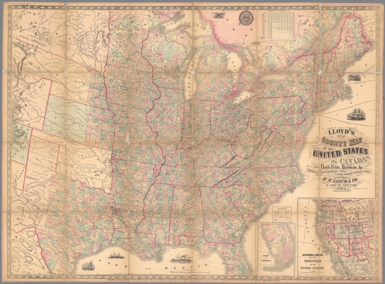
Full Title:
Lloyd's New County Map of the United States And Canadas showing Battle Fields, Railroads, &c. Compiled From The Latest Government Surveys & Other Reliable & Official Sources. Published by H.H. Lloyed & Co. 81 John St. New-York. 1863. Drawn And Engraved By Schonberg & Co., New York. Entered ... 1863, by H.H. Lloyd & Co. ... New York. Published By H.H. Lloyd & Co. ... B.B. Russell, 515 Washington St., Boston, R.R. Landon, 88 Lake St., Chicago ... (inset) California, Oregon And The Territories Of The United States ... (inset) Part Of Florida.
List No:
5148.000
Publication Author:
Lloyd, H.H.
Publication Author:
Schonberg & Co.
Pub Date:
1863
Pub Title:
Lloyd's New County Map of the United States And Canadas showing Battle Fields, Railroads, &c. Compiled From The Latest Government Surveys & Other Reliable & Official Sources. Published by H.H. Lloyed & Co. 81 John St. New-York. 1863. Drawn And Engraved By Schonberg & Co., New York. Entered ... 1863, by H.H. Lloyd & Co. ... New York. Published By H.H. Lloyd & Co. ... B.B. Russell, 515 Washington St., Boston, R.R. Landon, 88 Lake St., Chicago ... (inset) California, Oregon And The Territories Of The United States ... (inset) Part Of Florida.
Pub Reference:
Stevenson 47 (listed under Schonberg & Co.); Karrow 1645.
Pub Note:
Unusual collaboration between H.H. Lloyd and Schonberg & Co. The map shows the U.S. west to about half of Colorado Territory. Two inset maps show Southern Florida, and California, Oregon and the other Western Territories. Battlefields of the Civil War are indicated. The printing is somewhat crude lithography, with the western parts shown in a curious, distorted projection. This was probably rushed into printing to meet the demand for war maps. Full color by county. Map is bordered with linen, dissected into 24 sections, and folds down to 25x23 with brown paper end sheets; missing case.
Pub List No:
5148.000
Pub Type:
Case Map
Pub Height cm:
25
Pub Width cm:
23
Image No:
5148000.jp2
Authors:
Lloyd, H.H.; Schonberg & Co.