COLLECTION NAME:
David Rumsey Historical Map Collection
Record
Author:
Herrera y Tordesillas, Antonio de, -1625
Date:
1622
Short Title:
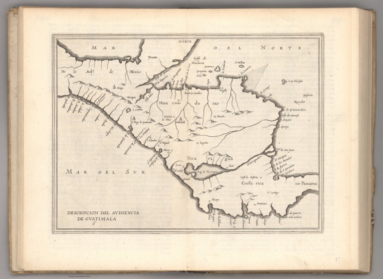
Descripcion del audiencia de Guatimala.
Publisher:
Colijn, Michiel
Publisher Location:
Amsterdam
Type:
Atlas Map
Obj Height cm:
21
Obj Width cm:
29
Note:
Map of Guatemala. Shows countries, regions, cities, topography, bodies of water, drainage, coastlines, shoals and islands. Relief shown pictorially. Black and white engraving. Map is 21 x 29 cm, on double sheet 29 x 36 cm. Appears in Descriptio Indiae Occidentalis per Antonium de Herrera regium Indiarum et Castellae historiographum, the first part of Nieuwe werelt anders ghenaempt West-Indien.
Country:
Guatemala
Subject:
Exploration
Full Title:
Descripcion del audiencia de Guatimala.
List No:
14476.011
Page No:
6
Series No:
11
Publication Author:
Herrera y Tordesillas, Antonio de, -1625
Publication Author:
Ordóñez de Ceballos, Pedro, approximately 1545-approximately 1630
Publication Author:
Le Maire, Jacques, 1585-1616
Pub Date:
1622
Pub Title:
Nieuwe werelt anders ghenaempt West-Indien. t'Amsterdam, by Michiel Colijn, Boeck-vercooper op't water by de oude brugh, in't huys-boeck. Anno 1622.
Pub Note:
Nieuwe werelt anders ghenaempt West-Indien, published by Michiel Colijn in Amsterdam in 1622. Three titles, separately paginated but issued together. The titles are authored by Antonio de Herrera y Tordesillas (-1625), Pedro Ordóñez de Ceballos (approximately 1545 - approximately 1630) and Jacques Le Maire (1585-1616), respectively. Bound in contemporary vellum, with early handwritten annotations, in ink, on pastedown of front cover verso. Collation: printed title-leaf, engraved title-leaf, [4], 111 pages, with fourteen engraved maps on double-sheets; second title-leaf, 3-99 pages; blank leaf; third title-leaf, engraved portrait of Le Maire on verso; seven dedication and preface leaves, 72 pages, numbered leaves 73-85, with three engraved maps (two double-sheet, one fold-out) and five engraved views. Three significant accounts of “New World” and Pacific explorations, bound together as issued. Most important is the first publication of the full journal of Jacques Le Maire’s circumnavigation, the first voyage to successfully round Cape Horn. The first part is Antonio de Herrera’s account, derived from the Spanish original, Descripcion de las Indias Occidentales, which was first published in Madrid in 1601. It was next published in Latin, French and Dutch editions, all issued in Amsterdam in 1622, using the same engravings (with some variations in the compositions of various editions). The Dutch edition of Herrera was issued with the two additional works: that of Ceballos’ account of the West Indies, and La Maire’s illustrated account of "Terra Australis" (Latin for "Southern Land”). The first two parts focus on knowledge of the New World; the first part with maps of North, Central and South America and the Pacific Coast, including New Guinea and other Pacific islands, which added considerable new information of geographical knowledge of the time. In addition, the Latin title page to Herrera’s work is decorated with Castilian coat of arms, vignettes of six Aztec gods and scenes of Nova Hispania [Mexico], including a temple. The third part traces La Maire’s voyage of 1616, in search of Terra Australis, a hypothetical continent first posited in antiquity. This work represents the first true publication of the journal from the Le Maire-Schouten expedition around the world. Sailing through Le Maire Strait and rounding Patagonia via Cape Horn, this voyage had an enormous effect on future navigation, helping to end the imagined idea of a Southland. Le Maire established for the first time that New Guinea was not part of a great continent extending indefinitely to the East. This understanding altered the European perception of the archipelago, which had gone unchanged since 1545. Also, Le Maire’s voyage around Cape Horn relieved the trading monopoly of the East India Company by finding an alternative route to the East Indies that did not violate the Company Charter, which prevented other Dutch trading companies from using the existing routes of the Straits of Magellan and Cape of Good Hope. Partly inspired by Quiros and motivated by Dutch trading zeal, this was the essential precursor to Tasman’s voyage. Tasman made great use of Le Maire’s mapping of the ocean. The Le Maire voyage, the last of the 17th-century expeditions to search for the hypothetical continent from its east, was responsible for extensive discoveries in the Pacific, shown in detail on the various maps and views contained herein. Three of the views show the Eendract ship at anchor in the Solomon and Cocos Islands. The small map on the title pages of both the first and third works is the earliest published cartographic representation of California as an island, a cartographic myth that persisted until the 18th century. Herrera was the official historian to Kings Philip II, III and IV, and his Nieuwe Werelt is a precursor to his magnum opus, Historia general de los hechos de los Castellanos en las Islas Terra Firme Del Mar Oceano, which eventually covered eight decades of voyages and travels published from 1601 to 1615. See full imagery of the volume at The Internet Archive (link in Pub Reference field). Historical notes from William Reese Company, New Haven.
Pub List No:
14476.000
Pub Type:
Regional Atlas
Pub Type:
Exploration Book
Pub Maps:
17
Pub Height cm:
29
Pub Width cm:
20
Image No:
14476011.jp2
Authors:
Herrera y Tordesillas, Antonio de, -1625