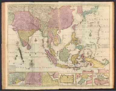
Detail View: David Rumsey Historical Map Collection: Composite Map: 1 Partie de la nouvelle grande carte des Indes Orientales, contenant les Terres du Mogol, Surate, Malabar, Cormandel, Bengale, Aracan, Pegu, Siam, Camboje, Tonquin, & une partie de la Chine ...
|
Author:
|
Elwe, Jan Barend
|
|
Date:
|
1792
|
|
Short Title:
|
Composite Map: 1 Partie de la nouvelle grande carte des Indes Orientales, contenant les Terres du Mogol, Surate, Malabar, Cormandel, Bengale, Aracan, Pegu, Siam, Camboje, Tonquin, & une partie de la Chine ...
|
|
Publisher:
|
Elwe, Jan Barend
|
|
Publisher Location:
|
Amsterdam
|
|
Type:
|
Composite Map
|
|
Obj Height cm:
|
98
|
|
Obj Width cm:
|
118
|
|
Scale 1:
|
7,500,000
|
|
Note:
|
Composite map of Asia, including the Mughal Empire [current-day India, Pakistan and Afghanistan], the Malabar, Coromandel, Bengal and Aracan regions, Siam [current-day Thailand], Camdodia, Tonquin [current-day Vietnam], China, Japan, the Philippines, the Mariana Islands, Maldives, Ceylon [current-day Sri Lanka], Malaysia, Sumatra (Indonesia), Borneo, Java, Celebes [Sulawesi], Gilolo [Halmahera], the Maluku Islands (Indonesia), Mindanao (Philippines) and Papua New Guinea. Shows countries, regions, cities, topography, vegetation, bodies of water, drainage, coastlines and islands. Relief shown pictorially. Includes compass roses with north oriented toward top of sheet, bar scales, latitudinal and longitudinal lines, and descriptive notes throughout. Inset maps: Carte de Royaume de Couchin de Coilan et de Cranganor -- Carte de Nigombo, Colombo -- Carte de Princepaute de Soerabaye et Terre de Grissik -- Isle de Sumbawa -- Isles de Serbira et de Solor -- Isles de Bouton et Pangesane. Hand-colored engraving. Composite map is 98 x 118 cm, on four double sheets, together 116 x 140 cm.
|
|
World Area:
|
Asia
|
|
Country:
|
India
|
|
Country:
|
Pakistan
|
|
Country:
|
Afghanistan
|
|
Country:
|
Thailand
|
|
Country:
|
Camdodia
|
|
Region:
|
Malabar Region (India)
|
|
Region:
|
Coromandel Coast (India)
|
|
Region:
|
Bengal Basin
|
|
Region:
|
Mariana Islands
|
|
Region:
|
Sumatra (Indonesia)
|
|
Full Title:
|
(Composite Map to) 1 Partie de la nouvelle grande carte des Indes Orientales, contenant les Terres du Mogol, Surate, Malabar, Cormandel, Bengale, Aracan, Pegu, Siam, Camboje, Tonquin, & une partie de la Chine -- 2 Partie de la nouvelle grande carte des Indes Orientales, contenant les Empires de la Chine & du Japon, les Isles Philippines, Couchin, & les Isles Marianes -- 3 Partie de la nouvelle grande carte des Indes Orientales, contenant les Isles Maldives, Ceyi, An, Malacca, Sumatra &c. avec les terres adjacentes de Couchin, Negombo, Colombo & Sourabaia -- 4 Partie de la nouvelle grande carte des Indes Orientales, contenant les Isles de Borneo, Java, Celebes, Mindanao, Gilolo, Molucques, La Nouvelle Guinée, La Nouvelle Bretagne, & les Nouvelles Philippines; avec les Isles de Sumbawa, Serbira, Solor, Bouton & Pangesane dressée avec soin, sur pluseurs cartes manuscrites, par un habile connoisseur; & publiée a Amsterdam par Jan Bt. Elwe. MDCCXCII.
|
|
List No:
|
14478.048
|
|
Page No:
|
29-32
|
|
Series No:
|
48
|
|
Publication Author:
|
Elwe, Jan Barend
|
|
Pub Date:
|
1792
|
|
Pub Title:
|
Atlas der wereld. Amstelædami, Chés J. B. Elwe.
|
|
Pub Note:
|
Atlas der wereld, by Jan Barend Elwe; published in Amsterdam, 1792. Title translates to: Atlas of the world. Bound in contemporary half-calf over marbled paper boards. With gilt ornamentation and title on spine. Collation - Folio: 22 pages, 40 leaves of plates. Comprised of letterpress text, an engraved title page, 37 maps, one timeline and one table of distances for Europe. Geographic coverage includes Europe, Russia, the Middle East, the Holy Land, East and Southeast Asia, Africa, North America and South America. Maps show continents, countries, regions, cities, churches, railways, topography, deserts, bodies of water, drainage, coastlines, islands and routes of exploration. With pictorial vignettes of figures, fauna and flora. This historical atlas in which Elwe re-issued maps by De L’Isle, Ottens, Jaillot, and other 17th-century cartographers continued the 17th-century Franco-Dutch mapmaking tradition long after it had been eclipsed by the 18th-century English mapmakers. The work is an intriguing bookend on a cartographic tradition - “the golden age of cartography” - that shaped much of the modern world.
|
|
Pub List No:
|
14478.000
|
|
Pub Type:
|
World Atlas
|
|
Pub Maps:
|
37
|
|
Pub Height cm:
|
59
|
|
Pub Width cm:
|
36
|
|
Image No:
|
14478048.jp2
|
|
Download 1:
|
|
|
Download 2:
|
|
|
Authors:
|
Elwe, Jan Barend
|