COLLECTION NAME:
David Rumsey Historical Map Collection
Record
Author:
Pelet, Paul, 1849-1927
Author:
Challamel, Augustin, 1818-1894
Author:
Hausermann, R., active 1875-1915
Date:
1889
Short Title:
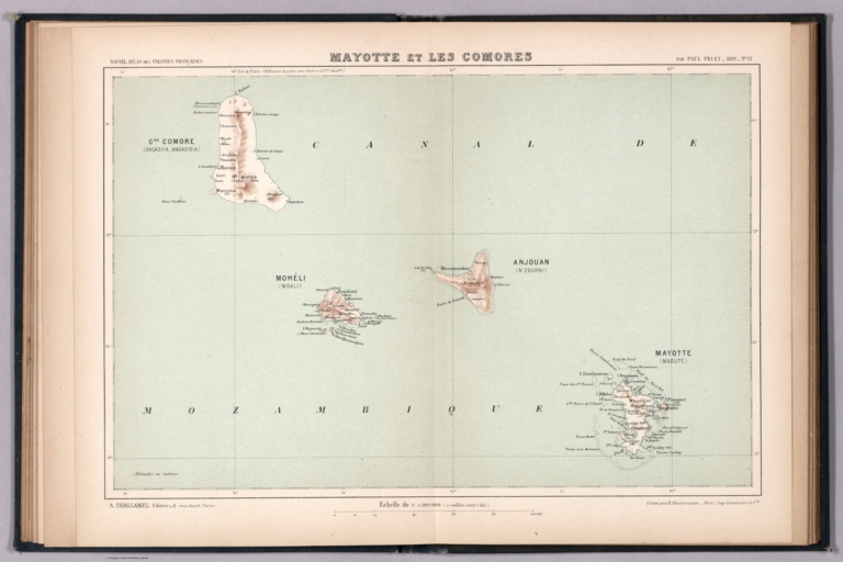
Mayotte et les Comores.
Publisher:
Librairie Coloniale
Publisher Location:
Paris
Type:
Atlas Map
Obj Height cm:
21
Obj Width cm:
32
Scale 1:
1,000,000
Note:
Map of Mayotte and the Comoros. Shows place names, transportation routes, topography, drainage, coastlines, islands and ports. Relief shown with hachures. Includes latitudinal and longitudinal lines, as well as a bar scale and a scale statement. Colored lithograph. Map is 21 x 32 cm, on sheet 26 x 37 cm. Accompanied by descriptive text of the same title, on preceding pages in section XII. In third part of atlas, Océan Indien.
Country:
Comoros
Region:
Mayotte Archipelago
Full Title:
Mayotte et les Comores. Nouvel atlas des colonies Françaises par Paul Pelet, 1889, No 12. A. Challamel, Éditeur, 5 rue Jacob, Paris. Gravé par R. Hausermann, Paris, Imp. Lemercier et Cie.
List No:
14300.038
Page No:
12
Series No:
38
Engraver or Printer:
Firmin-Didot (Firm)
Engraver or Printer:
Imprimerie Lemercier et cie
Publication Author:
Pelet, Paul, 1849-1927
Publication Author:
Challamel, Augustin, 1818-1894
Pub Date:
1891
Pub Title:
Nouvel atlas des colonies Françaises dressé par ordre de l'Admiistration des Colonies par Paul Pelet, Professeur de Géographie Coloniale a l'École des Sciences Politiques Membre du Comité Géographique des Colonies. Paris, Augustin Challamel, Éditeur, Librairie Coloniale. 5, rue Jacob, et Rue Furstenberg, 2. 1891.
Pub Note:
Nouvel atlas des colonies Françaises dressé par ordre de l'Admiistration des Colonies par Paul Pelet, published in Paris, 1891. Title translates to: New atlas of the French colonies drawn up by order of the Colonial Administration by Paul Pelet. Bound in navy-colored board with title, author and editor gilded on front cover. Collation: 4° : volume 1 : [viii], [xxxiv], 740 pages, [30] leaves of plates, including 1 fold-out ; vol. 2 : xii, 120, cxliv, [CIII] pages, [20] leaves of plates. Contains twenty-four plates with maps, including one overview world map with French colonies around the globe. Maps divided into six sections: [World] -- Afrique -- Océan Indien -- Indochine -- Océanie -- Amérique. Maps show place names, transportation routes, topography, lakes, drainage, coastlines, ports and islands. Each map accompanied by descriptive text preceding plate. Includes a table of contents, which follows text and maps.
Pub List No:
14300.000
Pub Type:
Regional Atlas
Pub Maps:
24
Pub Height cm:
27
Pub Width cm:
21
Image No:
14300038.jp2
Authors:
Pelet, Paul, 1849-1927; Challamel, Augustin, 1818-1894; Hausermann, R., active 1875-1915