COLLECTION NAME:
David Rumsey Historical Map Collection
Record
Author:
Sydow, Emil von., 1812-1873
Author:
Wagner, Hermann, 1840-1929
Date:
1940
Short Title:
No. 60. Nordpolarkarte
Publisher:
Justus Perthes
Publisher Location:
Gotha
Type:
Atlas Map
Obj Height cm:
28
Obj Width cm:
33
Scale 1:
30,000,000
Note:
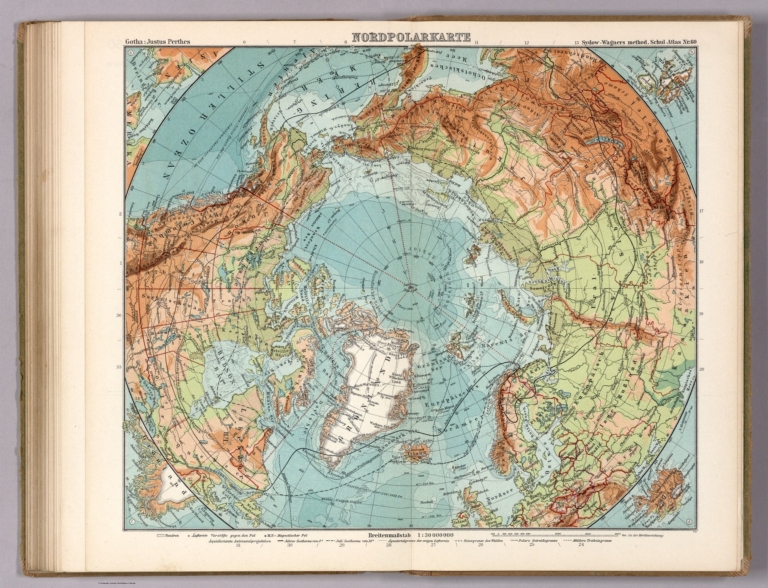
Arctic region map, with the North Pole at map center. Includes 4 insets. Aquidistante Azmutal projektion
Region:
Arctic regions
Subject:
Physical
Full Title:
Nordpolarkarte. Gotha : Justus Perthes. Sydow-Wagners method. Schul-Atlas. XXI.
List No:
13557.147
Page No:
60 map
Series No:
147
Engraver or Printer:
Haack, Hermann, 1872-1966
Engraver or Printer:
Lautensach, Hermann, 1886-1971
Publication Author:
Sydow, Emil von., 1812-1873
Publication Author:
Wagner, Hermann, 1840-1929
Pub Date:
1940
Pub Title:
Sydow-Wagners methodischer Schul-Atlas : 21 Auflage. Bearbeitet von H. Haack und H. Lautensach. 67 haupt - und 232 nebenkarten auf 64 tafeln mit einem namenverzeichnis. Berichtigter Neudruck 1940. Justus Perthes in Gotha.
Pub Note:
1940. 21st. edition of Sydow-Wagner's methodical school atlas of the world. Edited by H. Haack and H. Lautensach. Revised and reprint from the original edition of 1889 and published by Justus Perthes in Gotha, 1940. Contains XVI, 64 page, 67 main map, some double page, 232 secondary maps, in variable scales in color and black and white, Maps include color coded reference, text, legend, secondary title page, some with location map and index. Atlas consists of political and thematic maps, city plans and views. Showing political boundaries, major cities, towns, roads, railroads, rivers, lakes shipping routes, distances, and mountains. Also showing routes of voyages and discovery. Relief shown by hachures, spot heights and gradient tints. Depth shown by bathymetric tints, isolines and soundings. Prime meridian: Greenwich. Bound in hard cover green paper with linen spine and title “Sydow-Wagners methodischer Schul-Atlas, Justus Perthes”. Atlas accompanied by supplemental alphabetical index: Namenverzeichniz in 42 pages, a manuscript map and a postcard map “Landtcarte von dem Nortfrieslande … Anno 1651”.
Pub List No:
13557.000
Pub Type:
World Atlas
Pub Maps:
73
Pub Height cm:
32
Pub Width cm:
21
Image No:
13557147.jp2
Authors:
Sydow, Emil von., 1812-1873; Wagner, Hermann, 1840-1929