COLLECTION NAME:
David Rumsey Historical Map Collection
Record
Author:
Andriveau-Goujon, E. (Eugène), 1832-1897
Date:
1876
Short Title:
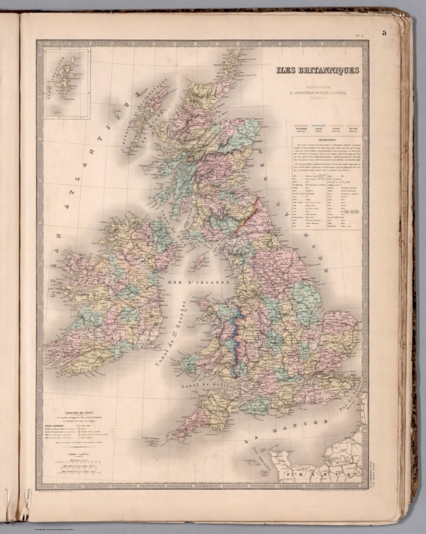
(5) Iles Britanniques.
Publisher:
E. Andriveau-Goujon
Publisher Location:
Paris
Type:
Atlas Map
Obj Height cm:
63
Obj Width cm:
47
Scale 1:
1,900,000
Note:
Hand-colored, engraved map of Scandinavia, showing political boundaries, roads and railroad lines (with decorative border). Includes legend and 3 bar scales. Features "Observations" text, including translations into French. "No. 5" in upper right; "Atlas usuel, No. 5" and "Atlas universel, No. 18" in lower right. With inset: (Isles Shetland).
Region:
British Isles
Region:
Shetland Islands
Subject:
Railroad
Full Title:
(5) Iles Britanniques. Paris, 1876, E. Andriveau-Goujon, éditeur, Rue du Bac, 4. Paris, Impie. de Louis Antoine, Rue des Noyers, 70; gravé le trait par Smith; les montagnes par Gérin; les escritures par P. Rousset; les eaux par Mme. Fontaine.
List No:
14008.008
Page No:
5
Series No:
8
Engraver or Printer:
Antoine, Louis
Engraver or Printer:
Smith, Ch.
Engraver or Printer:
Gérin
Engraver or Printer:
Rousset, P.
Engraver or Printer:
Fontaine, Mme.
Publication Author:
Andriveau-Goujon, E. (Eugène), 1832-1897
Pub Date:
1881
Pub Title:
Atlas universel de géographie moderne. Publié par E. Andriveau-Goujon, Paris: Rue du Bac, 4.
Pub Reference:
Geographicus : Rare antique maps. Andriveau-Goujon (fl. 1805 - 1894). https://www.geograp…
Pub Note:
World atlas published by Eugène Andriveau-Goujon, including 25 maps, as well as a diagram showing the comparative heights of mountains and lengths of rivers. Publication date estimated to be 1881, based upon the latest date found within the atlas (see maps 6, 8, 9, 16, 17, 19). Short titles for maps transcribed from tables of contents; full titles transcribed directly from maps. Prime meridian is Paris (see maps 23 and 25). Eugène Andriveau-Goujon (1832 - 1897) was a map publisher and cartographer active in 19th century Paris. Maps by Andriveau-Goujon are often confusing to identify as they can be alternately singed J. Goujon, J. Andriveau, J.Andriveau-Goujon, E. Andriveau-Goujon, or simply Andriveau-Goujon. This refers to the multiple generations of the Andriveau-Goujon dynasty and the tendency to republisher older material without updating the imprint. The earliest maps to have the Andriveau-Goujon imprint were released by Jean Andriveau-Goujon. He passed the business to his son Gilbert-Gabriel Andriveau-Goujon, who in 1858 passed to his son, Eugène Andriveau-Goujon, under whose management the firm was most prolific. Andriveau-Goujon published numerous fine pocket maps and atlases throughout the 19th century and often worked with other prominent French cartographers of the time such as Brue and Levasseur
Pub List No:
14008.000
Pub Type:
World Atlas
Pub Maps:
26
Pub Height cm:
71
Pub Width cm:
54
Image No:
14008008.jp2
Authors:
Andriveau-Goujon, E. (Eugène), 1832-1897