COLLECTION NAME:
David Rumsey Historical Map Collection
Record
Author:
Cram, George Franklin, 1841-1928
Date:
1899
Short Title:
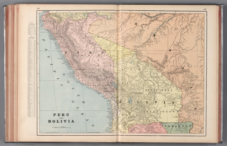
Peru and Bolivia.
Publisher:
Geo. F. Cram
Publisher Location:
New York
Publisher Location:
Chicago
Type:
Atlas Map
Obj Height cm:
40
Obj Width cm:
55
Scale 1:
5,500,000
Note:
Map of Peru and Bolivia. Shows political boundaries, cities, railroads, topography, bodies of water, drainage, coastlines and islands. Relief shown with hachures. Includes latitudinal and longitudinal lines, as well as a bar scale given in miles. Provides figures for square milage and population. Map indexed to indicate place names. Colored lithograph. Map is 40 x 55 cm, on double sheet 45 x 67 cm.
Country:
Peru
Country:
Bolivia
Subject:
Railroad
Full Title:
Peru and Bolivia.
List No:
14372.309
Page No:
536-537
Series No:
309
Engraver or Printer:
Cram, George Franklin, 1841-1928
Publication Author:
Cram, George Franklin, 1841-1928
Pub Date:
1899
Pub Title:
Cram's standard American railway system atlas of the world. Accompanied with a complete and simple index of the United States showing the true location of all railroads, towns, villages and post offices ... Maps of the United States are the largest scale and clearest print of any maps published. Foreign maps are compiled largely from charts of the Royal Geographical Society and are geographically correct. Published by Geo. F. Cram, 89 Fulton Street, New York; 61-63 Plymouth Place, Chicago, 1899.
Pub Note:
Cram's standard American railway system atlas of the world, by George F. Cram; published in New York and Chicago, 1899. Bound in dark teal-colored board, which has been reinforced with duct tape. Front cover includes title, advertisement and "Index to United States, Canada and Mexico maps". With green floral end papers. Collation: 2° : [1-4], 5-510, 515-608, [1-42] pages. Atlas comprised of 231 maps, with geographic coverage of the United States as a whole and each of its fifty states, as well as Canada, Central America, South America, the West Indies, Europe, the Middle East, Asia, Africa, the East Indies, Australia and New Zealand. Also, with several city maps, including San Francisco, New York, Philadelphia, Detroit, Atlanta, Dallas and Denver. Maps show political boundaries, counties, towns, Indian reservations, mines, railroads, roads, steamship lines, topography, bodies of water, drainage, coastlines, islands and water routes with distances. Some maps provide figures for square mileage and population. Volume includes title page, table of contents, and index pages associated with state maps, as well as 42 (unnumbered) pages with “Special list of attorneys in every banking town in the United States” and “Bank directory containing one or more principal banks and bankers in each city and town in the United States, who make a specialty of collections and general banking business”. According to the title, “Maps of the United States are the largest scale and clearest print of any maps published. Foreign maps are compiled largely from charts of the Royal Geographical Society and are geographically correct.” For the 1901 edition of the atlas, see Pub List No. 2809.000.
Pub List No:
14372.000
Pub Type:
World Atlas
Pub Type:
Thematic Atlas
Pub Maps:
231
Pub Height cm:
47
Pub Width cm:
35
Image No:
14372309.jp2
Authors:
Cram, George Franklin, 1841-1928