COLLECTION NAME:
David Rumsey Historical Map Collection
Record
Author:
Verbeek, Rogier Diederik Marius (1845 - 1926)
Author:
Fennema, Reinder (1849 – 1897)
Date:
1896
Short Title:
B. I Geologische kaart van Java en Madoera in 26 Bladen
Publisher:
Giesecke & Devrient for Joh. G. Stemmler Cz
Publisher Location:
Leipzig
Type:
Separate Map
Obj Height cm:
49
Obj Width cm:
56
Scale 1:
200,000
Country:
Indonesia
Region:
Java (Indonesia)
Subject:
Geology
Full Title:
B. I Geologische kaart van Java en Madoera in 26 Bladen. Opgenomen door de Hoofdingenieurs van het Mijnwezen Dr. R.D.M. Verbeek en R. Fennema met medewerking van de Topografen J.G. de Groot en M.H.A. Voorsmit, de Opzieners bij het Mijnwezen J.F. de Corte en H.P.J. Naumann en den teekenaar A.L.E. Gaston in de jaren 1886-1894.
List No:
15561.008
Series No:
8
Publication Author:
Verbeek, Rogier Diederik Marius (1845 - 1926)
Publication Author:
Fennema, Reinder (1849 – 1897)
Pub Date:
1896
Pub Title:
Geologische kaart van Java en Madoera in 26 Bladen. Opgenomen door de Hoofdingenieurs van het Mijnwezen Dr. R.D.M. Verbeek en R. Fennema met medewerking van de Topografen J.G. de Groot en M.H.A. Voorsmit, de Opzieners bij het Mijnwezen J.F. de Corte en H.P.J. Naumann en den teekenaar A.L.E. Gaston in de jaren 1886-1894.
Pub Reference:
University of Leiden Library: 505-18-003; Bayerische Staatsbibliothek: Mapp. XXIV,140 wn#Bl.1/26:; OCLC: 164602145, 780039996: J.T. van GORSEL, Pioneers and Milestones of Indonesian Geology (~1820-1960s): 2- The Geological Survey, Volcanology (ITB Press for the Geological Engineering - Institut Teknologi Bandung Bandung, 2022), p. 68.
Pub Note:
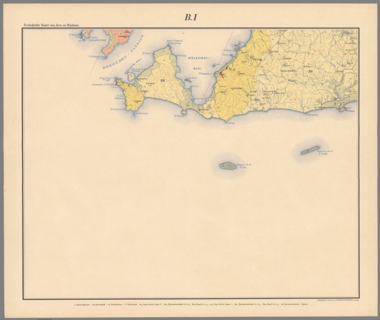
"The apogee of geological cartography in 19th century Asia, being a colossal 26-sheet geological map (that if joined would measure 1.5 x 5.5 metres / 5 x 18 feet!!!), the result of eight years of advanced scientific systematic surveys conducted by an expert team led by the esteemed mining engineers Rogier Diederik Marius Verbeek and Reinder Fennema, the project commissioned by the Governor-General of the Dutch East Indies to aid an ongoing petroleum and infrastructure boom, as well as being motivated by a heightened interest volcanology due to the recent eruption of Krakatoa, published in the finest colour lithography by the specialist Leipzig firm of Giesecke & Devrient – very rare. Java, with an area of 138,800 sq km is the 13th largest island in the world and was always densely populated (today it is home to over 150 million, making it the most populous island in the world). Located along the subduction of the Australian and Sunda tectonic plates, its backbone is composed of a chain of high, active volcanoes (including its highest peak, Mount Semeru, 3,376 m /12,060 ft), and is one of the most volcanically active areas of the globe. This has given Java an exceptionally complex geological profile. Java had been under Dutch colonial oversight since the early 17th century. However, up to the late 19th century, the geology of the island was only imprecisely known. While major modern agricultural, infrastructure, mining and latterly petroleum exploration projects had generated a small corpus of scientific geological maps, most of these remained in manuscript form, and contributed little to the overall understanding of the field. The lack of precise and comprehensive geological knowledge of Java came to be seen as a major hindrance to development, motivating grand measures. In 1886, the Governor-General of the Dutch East Indies (Indonesia) commissioned a complete geological survey of Java, executed to the highest scientific and systematic standards. This promised to be a very expensive and laborious endeavour but was seen a top priority for four main reasons. First, advanced geological mapping was necessary for oil exploration, which was of profound economic importance to the colonial regime. In 1869, 44 oil seeps were discovered in Java, and drilling for petroleum commenced in 1872. It was thought that much larger deposits could be found if only better geological mapping was available. Second, the colonial regime was in the midst of a railway boom. The first line in Java was inaugurated in 1867, and since then the system had been dramatically expanded. However, the lack of precise geological mapping was proving a frag on construction. Third, Java is one of the most volcanically active places on earth and the recent eruption of Krakatoa, a small volcanic island in the Sunda Strait, between Java and Sumatra, on August 26/27, 1883, brought the matter into sharp relieve. The eruption caused a series of massive explosions that were 13,000 times as strong as the ‘Little Boy’ atomic bomb that would be dropped on Hiroshima in 1945 (Verbeek was an eyewitness the eruption and the author of the official, definitive account of the event). The government believed that better awareness of geology would allow for improved preparedness in the face of future volcanic incidents. Fourth, the commissioning of the geological survey of Java must be seen as part of the Dutch colonial regime’s overarching policy of tightening control over the island. While Java had nominally been under Dutch rule since the early 17th century, for generations the Dutch only directly controlled their major trading centres, leaving the hinterland to be run by local indigenous leaders under fealty agreements with the regime. However, in the mid- to late- 19th century the colonial authorities endeavoured to gain direct governance over almost the entire island. In 1886, Otto van Rees, the Governor-General of the Dutch East Indies inaugurated the geological survey of Java, allocating it generous resources, a great accolade for the project from what was otherwise a famously parsimonious administration. Rogier Diederik Marius Verbeek was chosen to head the programme, with Reinder Fennema serving as his chief lieutenant. The professional team was rounded out by the engineers J.G. de Groot, M.H.A. Voorsmit, and the mining supervisors J.F. de Corte, H.P.J. Naumann and the draftsman A.L.E. Gaston. For eight years the team, split up into field units, laboured over massive volcanic peaks, through thick jungle and across vast tracks of farmland to systematically and exhaustively survey every inch of the geology of Java, without compromising the very strict technical standards enforced by Verbeek and Fennema. The endeavour benefitted from the fact that the colonial Topographische Dienst (Topographical Service), had already mapped the island to a reasonably high degree of scientific precision, providing a good underlying template for the geological information. It was one of the most challenging and impressive such endeavours ever accomplished and ranks as the apogee of geological mapping in 19th century Asia. The Present Map in Focus The Java survey’s manuscripts, drafted under the supervision of A.L.E. Gaston, were sent to the Netherlands for inspection, where they met with universal acclaim. It was decided that they would be printed by the finest available colour lithography, so the manuscripts were sent to the specialist Leipzig firm of Giesecke & Devrient, which was renowned for its virtuosity in the medium. The present map is colossal, embracing Java to a grand scale of 1:200,000, and is printed upon 26 sheets, that, if joined, would have maximum dimensions of 1.5 x 5.5 metres (5 x 18 feet). The accompanying title sheet features the legend, ‘Verklarung der Kleuren en Teekens’ (Explanation of Colours and Signs) that identifies the resplendent colours used to show the map’s 33 distinct geological zones (classified into the Alluvial, Quaternary, Volcanic, Tertiary & Younger, Pliocene & Upper Miocene, Young & Middle Miocene, Ancient Miocene, Oldest Miocene, Oligocene, Eocene, and Chalk Formations). Additionally, symbols for geological features are noted, such as for beds and corridors of eruptive rocks; direction and slope of layers; crater rims; cola and lignite deposits; zinc, led, copper and manganese ores; areas of petrification; fossilized plants; rejections; lines of steep positions of layers; rock boundaries; and warm springs. The map’s geological information is overlaid upon the Topographische Dienst’s conventional mapping template, which is evident here in the very detailed and accurate depiction of cities, infrastructure and the general topography. The map also includes a ‘Verkortingen’, explaining the abbreviations of Bahasa geographical terms used throughout the map. The accompanying key map (‘Bladwijzer’) shows how to connect the 26 sheets. Importantly, the present map was not separately issued, although it is complete as a map in and of itself. It was originally published as part of a massive portfolio, or loose-leaf atlas, that included the present map, plus, 22 additional sheets of diagrams and supporting maps, being Verbeek & Fennema’s Geologische beschrijving van Java en Madoera door Dr. R.D.M. Verbeek en R. Fennema, Hoofdingenieurs van het Mijnwezen in Nederlandsch-Indie. / Atlas (Leipzig: Giesecke & Devrient for Joh. G. Stemmler Cz., 1896), which was further accompanied by an exhaustive textual description, being Verbeek & Fennema’s Geologische beschrijving van Java en Madoera door Dr. R.D.M. Verbeek en R. Fennema, Hoofdingenieurs van het Mijnwezen in Nederlandsch-Indie, 2 vols. (Amsterdam: Joh. G. Stemmler Cz., 1896). The portfolio is almost never found on the market complete, and even incomplete sets seldom appear, and there is evidence that the present map was often contemporarily extracted from the portfolio for consultation, and perhaps even for mounting. The Surveyors: Perhaps the Finest Geological Cartographers in 19th Century Asia Dr. Rogier Diederik Marius Verbeek (1845 - 1926) was an internationally-renown geologist and volcanologist who was more that anyone else responsible for introducing the most advanced standards of geological cartography to Southeast Asia. Educated in the home country, he assumed the post of Chief Engineer of Mines of the Dutch East Indies in 1881. His first major project was to conduct the first geological-mineralogical study and mapping of much of Sumatra’s west coast, resulting in the publication of the Topographische en geologische Beschrijving van een Deel van Sumatra's Westkust (Batavia, 1883). In 1883, Verbeek witnessed the eruption of Krakatoa, and the Governor-General commissioned him to conduct the definitive study of the event. This resulted in his masterly Krakatau, door R.D.M. Verbeek (Text volume: Batavia 1883), with a lavish elephant folio atlas (Brussels, 1884-5). This work made Verbeek a globally celebrated volcanologist. In 1886, he was appointed to head the mammoth project to geologically map Java. Verbeek retired from his role as Chief Engineer in 1893, and thence became the elder stamen of the geological community in the Dutch world, receiving innumerable honours. He continued to publish, notably writing an important article on the history of volcanism in East Java, De vulkanische erupties in Oost-Java in het laatst der 16de eeuw (1925). Reinder Fennema (1849 –1897) was a mining engineer, who graduated from the prestigious Delft University of Technology. In 1874, he was appointed by the Governor-General of the Dutch East Indies as an engineer in the colonial mining department. He played a major role in the mapping for petroleum exploration in Sumatra, resulting in tremendously important discoveries, as well as conducting a study of the geology of the northwest coast of Sumatra, resulting in the publication of the Topografische en geologische beschrijving van het Noordelijk gedeelte van Sumatra's Westkust met geologische kaart, in the Jaarboek voor het Mijnwezen (1887). As Verbeek’s chief lieutenant of the geological survey of Java he was notably responsible for the mapping of Mount Semeru, Java’s highest peak. He succeeded Verbeek as the Chief Engineer of Mines of the Dutch East Indies in 1893, but tragically drowned, in a freak accident, while surveying a lake in Sulawesi, in 1897 (his body was never found). A Note on Rarity The present map, and portfolio in which it was published would have been issued in only a limited print run, as it was a very lavish and expensive work. While several examples are held by (mainly Dutch) institutions, we are aware of only a couple examples of the incomplete portfolio, including the map, as having appeared on the market in the last generation. Moreover, a few institutions hold examples of the standalone map." (Alexander Johnson/Dasa Pahor, 2023)
Pub List No:
15561.000
Pub Type:
Separate Map
Pub Maps:
27
Pub Height cm:
49
Pub Width cm:
56
Image No:
15561008.jp2
Authors:
Verbeek, Rogier Diederik Marius (1845 - 1926); Fennema, Reinder (1849 – 1897)